Property Record
Longleaf Pine Pkwy, Saint Johns, FL 32259


Property Detail
Longleaf Pine Pkwy
009680-0000
1-4 PT OF SECS 3 10 & 11 LYING S OF CR 244 & W OF PROPOSED CR 223 - DEED PARCEL 4 (EX PT IN OR5371/1433) (EX PT PLAT AS MB112/39-54) (EX PT IN OR5584/1759) (EX PT IN MB118/85-89) OR4971/406
Timberlandforesttreesagricultural
ST. JOHNS
OR
Florida
AE The base floodplain where base flood elevations are provided. AE Zones are now used on new format FIRMs instead of A1-A30 Zones.
48.60 AC
2025
St Johns County
2026
Jacksonville (Florida)
020809
Jacksonville, FL
NEARBY LISTINGS FOR SALE OR LEASE
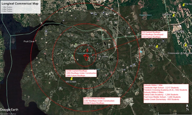
DEMOGRAPHICS near Longleaf Pine Pkwy
1 mile
3 mile
5 mile
2025 Total Population
3,645
44,986
118,834
2030 Population
4,254
51,791
134,405
Pop Growth 2025-2030
+ 16.71%
+ 15.13%
+ 13.10%
Average Age
35
37
38
2025 Total Households
1,087
14,227
40,926
HH Growth 2025-2030
+ 17.02%
+ 15.31%
+ 12.85%
Median Household Inc
$175,186
$148,318
$128,406
Avg Household Size
3.30
3.10
2.90
2025 Avg HH Vehicles
2.00
2.00
2.00
Median Home Value
$671,091
$591,405
$483,920
Median Year Built
2011
2010
2009
Nearby Places
Map Layers
Map Styles
 Street
 Aerial
Transit
 Traffic
 Biking
Places
Listings with unknown addresses are not visible on the map
- Restaurants
- Banks
- Shops
- Fitness
- Groceries
PUBLIC TRANSPORTATION
AIRPORT
Jacksonville International
Drive
Walk
Distance
Jacksonville International
50 min
38.0 mi
Freight Ports
Jacksonville Port
Drive
Walk
Distance
Jacksonville Port
38 min
27.0 mi
SALE & LEASE HISTORY
LISTING DATE
SALE/LEASE

Mar 21, 2022
For Lease
Nearby Properties
Address
Land Use
TOTAL SIZE
Lot Size
Zoning
Address
Land Use
TOTAL SIZE
Lot Size
Zoning
371,039 SF
20.63 AC
Address
Land Use
TOTAL SIZE
Lot Size
Zoning
295,881 SF
38.96 AC
Address
Land Use
TOTAL SIZE
Lot Size
Zoning
233,849 SF
101.31 AC
OR
Address
Land Use
TOTAL SIZE
Lot Size
Zoning
215.74 AC
Address
Land Use
TOTAL SIZE
Lot Size
Zoning
190,574 SF
20 AC
PUD
Address
Land Use
TOTAL SIZE
Lot Size
Zoning
158,388 SF
33.46 AC
OR
Address
Land Use
TOTAL SIZE
Lot Size
Zoning
78,903 SF
22.19 AC
Address
Land Use
TOTAL SIZE
Lot Size
Zoning
66,280 SF
9.45 AC
PUD
Address
Land Use
TOTAL SIZE
Lot Size
Zoning
191,230 SF
17.62 AC
Address
Land Use
TOTAL SIZE
Lot Size
Zoning
61,942 SF
44.39 AC
Address
Land Use
TOTAL SIZE
Lot Size
Zoning
123,398 SF
25.30 AC
PUD
Address
Land Use
TOTAL SIZE
Lot Size
Zoning
22,271 SF
11.29 AC
PUD
Address
Land Use
TOTAL SIZE
Lot Size
Zoning
59,535 SF
37.64 AC
OR
Address
Land Use
TOTAL SIZE
Lot Size
Zoning
58,139 SF
7.92 AC
OR
Address
Land Use
TOTAL SIZE
Lot Size
Zoning
38,266 SF
6.32 AC
Address
Land Use
TOTAL SIZE
Lot Size
Zoning
18,373 SF
8.47 AC
OR
Address
Land Use
TOTAL SIZE
Lot Size
Zoning
87,495 SF
22.41 AC
PUD
Address
Land Use
TOTAL SIZE
Lot Size
Zoning
1,249 SF
1.61 AC
Address
Land Use
TOTAL SIZE
Lot Size
Zoning
46,789 SF
5.86 AC
Address
Land Use
TOTAL SIZE
Lot Size
Zoning
156.70 AC
Address
Land Use
TOTAL SIZE
Lot Size
Zoning
23,950 SF
7.89 AC
Address
Land Use
TOTAL SIZE
Lot Size
Zoning
75,805 SF
36.69 AC
PUD
Address
Land Use
TOTAL SIZE
Lot Size
Zoning
23,842 SF
5.75 AC
PUD
Address
Land Use
TOTAL SIZE
Lot Size
Zoning
35,063 SF
12.63 AC
PUD
Address
Land Use
TOTAL SIZE
Lot Size
Zoning
11,998 SF
2.12 AC
Address
Land Use
TOTAL SIZE
Lot Size
Zoning
5,252 SF
2.50 AC
Address
Land Use
TOTAL SIZE
Lot Size
Zoning
30,133 SF
30 AC
IW
Address
Land Use
TOTAL SIZE
Lot Size
Zoning
300.50 AC
OR
Address
Land Use
TOTAL SIZE
Lot Size
Zoning
122,561 SF
48.29 AC
OR
Address
Land Use
TOTAL SIZE
Lot Size
Zoning
12,438 SF
1.95 AC
PUD
The World's #1 Commercial Real Estate Marketplace
Connect with us
© 2026 CoStar Group
The information above has been obtained from sources believed reliable. While we do not doubt its accuracy we have not verified it and make no guarantee, warranty or representation about it. It is your responsibility to independently confirm its accuracy and completeness. Any projections, opinions, assumptions, or estimates used are for example only and do not represent the current or future performance of the property. The value of this transaction to you depends on tax and other factors which should be evaluated by your tax, financial, and legal advisors. You and your advisors should conduct a careful, independent investigation of the property to determine to your satisfaction the suitability of the property for your needs.