Property Record
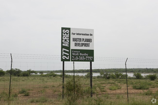
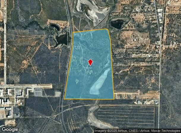
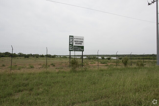
11603 Pleasanton Rd, San Antonio, TX 78221
NEARBY LISTINGS FOR SALE OR LEASE
Property Detail
11603 Pleasanton Rd
San Antonio-New Braunfels, TX
Conv A/S Code
04005-000-0250
CB 4005 P-25 & 26 ABS 15 138.530 AC CB 4283 P-20 ABS 769 3.332 AC (SOUTHSIDE STUDY AREA 2 ANNEXATION) ORDINANCE# 2007-101604/ADD TU21
Privatepreserveopenspacevacantlandforestlandconservation
Bexar
A
Texas
48029C0570F
25
2024
141.86 AC
2025
South
151700
San Antonio
DEMOGRAPHICS near 11603 Pleasanton Rd
1 Mile
3 Mile
5 Mile
2024 Total Population
2,504
56,129
125,857
2029 Population
2,732
60,093
134,181
Pop Growth 2024-2029
+ 9.11%
+ 7.06%
+ 6.61%
Average Age
30
35
36
2024 Total Households
673
17,305
40,588
HH Growth 2024-2029
+ 9.66%
+ 7.22%
+ 6.72%
Median Household Inc
$55,588
$53,913
$46,601
Avg Household Size
3.20
3.10
3.00
2024 Avg HH Vehicles
2.00
2.00
2.00
Median Home Value
$182,417
$147,431
$126,943
Median Year Built
2005
1983
1972
Nearby Places
Map Layers
Map Styles
 Street
 Aerial
- Restaurants
- Banks
- Shops
- Fitness
- Groceries
PUBLIC TRANSPORTATION
AIRPORT
San Antonio International
DRIVE
WALK
Distance
San Antonio International
28 min
18.4 mi
Freight Ports
Port of Corpus Christi
DRIVE
WALK
Distance
Port of Corpus Christi
148 min
142.6 mi
Nearby Properties
Address
Land Use
TOTAL SIZE
Lot Size
Zoning
Address
Land Use
TOTAL SIZE
Lot Size
Zoning
32,800 SF
198.68 AC
Address
Land Use
TOTAL SIZE
Lot Size
Zoning
309,482 SF
14.45 AC
Address
Land Use
TOTAL SIZE
Lot Size
Zoning
504,337 SF
45.55 AC
Address
Land Use
TOTAL SIZE
Lot Size
Zoning
211,365 SF
11.65 AC
Address
Land Use
TOTAL SIZE
Lot Size
Zoning
71,607 SF
10.46 AC
Address
Land Use
TOTAL SIZE
Lot Size
Zoning
11,553 SF
67.15 AC
Address
Land Use
TOTAL SIZE
Lot Size
Zoning
80,936 SF
13.48 AC
Address
Land Use
TOTAL SIZE
Lot Size
Zoning
526.61 AC
Address
Land Use
TOTAL SIZE
Lot Size
Zoning
38,671 SF
5.20 AC
Address
Land Use
TOTAL SIZE
Lot Size
Zoning
67,184 SF
60.16 AC
Address
Land Use
TOTAL SIZE
Lot Size
Zoning
590.88 AC
Address
Land Use
TOTAL SIZE
Lot Size
Zoning
244,072 SF
13.97 AC
Address
Land Use
TOTAL SIZE
Lot Size
Zoning
154,556 SF
7.52 AC
Address
Land Use
TOTAL SIZE
Lot Size
Zoning
116,964 SF
15.07 AC
Address
Land Use
TOTAL SIZE
Lot Size
Zoning
225,994 SF
12.25 AC
Address
Land Use
TOTAL SIZE
Lot Size
Zoning
168.41 AC
Address
Land Use
TOTAL SIZE
Lot Size
Zoning
67,184 SF
60.16 AC
Address
Land Use
TOTAL SIZE
Lot Size
Zoning
336,932 SF
17.01 AC
Address
Land Use
TOTAL SIZE
Lot Size
Zoning
411.04 AC
Address
Land Use
TOTAL SIZE
Lot Size
Zoning
85,882 SF
4 AC
Address
Land Use
TOTAL SIZE
Lot Size
Zoning
207.97 AC
Address
Land Use
TOTAL SIZE
Lot Size
Zoning
80,035 SF
3.95 AC
Address
Land Use
TOTAL SIZE
Lot Size
Zoning
21,986 SF
2.44 AC
Address
Land Use
TOTAL SIZE
Lot Size
Zoning
45,900 SF
2.92 AC
Address
Land Use
TOTAL SIZE
Lot Size
Zoning
25,435 SF
51.62 AC
Address
Land Use
TOTAL SIZE
Lot Size
Zoning
99,700 SF
8.97 AC
Address
Land Use
TOTAL SIZE
Lot Size
Zoning
155.69 AC
Address
Land Use
TOTAL SIZE
Lot Size
Zoning
71,807 SF
5.30 AC
Address
Land Use
TOTAL SIZE
Lot Size
Zoning
16,212 SF
1.35 AC
Address
Land Use
TOTAL SIZE
Lot Size
Zoning
46,142 SF
4.67 AC
The World's #1 Commercial Real Estate Marketplace
Connect with us
© 2026 CoStar Group
The information above has been obtained from sources believed reliable. While we do not doubt its accuracy we have not verified it and make no guarantee, warranty or representation about it. It is your responsibility to independently confirm its accuracy and completeness. Any projections, opinions, assumptions, or estimates used are for example only and do not represent the current or future performance of the property. The value of this transaction to you depends on tax and other factors which should be evaluated by your tax, financial, and legal advisors. You and your advisors should conduct a careful, independent investigation of the property to determine to your satisfaction the suitability of the property for your needs.