Property Record
Los Altos Pkwy, Sparks, NV 89436
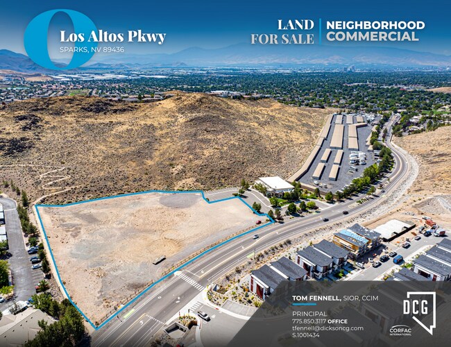
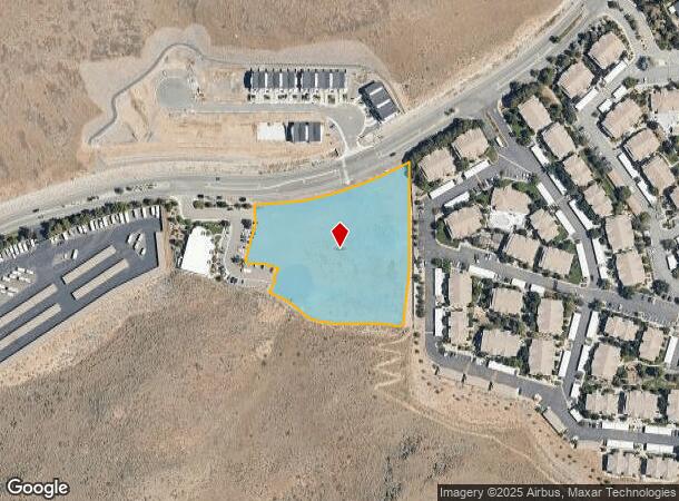
This Property Is For Sale
Current Lease Availabilities
NEARBY LISTINGS FOR SALE OR LEASE
Property Detail
Los Altos Pkwy
Reno, NV
_Unspecified
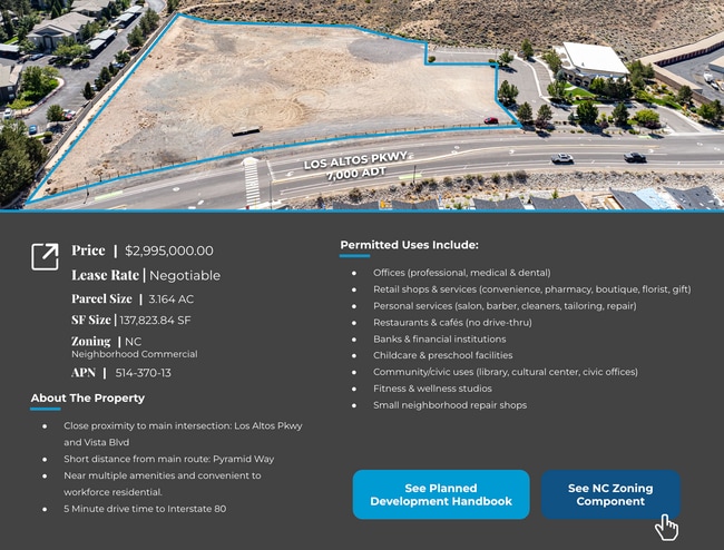
514-370-13
PM 5064 PAR 2-B
Vacantlandnec
Washoe
X
Nevada
32031C3054G
2-b
2024
3.16 AC
2025
Sparks
003512
Reno/Sparks
DEMOGRAPHICS near Los Altos Pkwy
1 Mile
3 Mile
5 Mile
2024 Total Population
9,861
62,145
142,448
2029 Population
10,076
63,545
146,608
Pop Growth 2024-2029
+ 2.18%
+ 2.25%
+ 2.92%
Average Age
41
41
40
2024 Total Households
3,774
23,694
53,357
HH Growth 2024-2029
+ 2.28%
+ 2.42%
+ 3.05%
Median Household Inc
$105,357
$95,309
$84,319
Avg Household Size
2.60
2.60
2.60
2024 Avg HH Vehicles
2.00
2.00
2.00
Median Home Value
$641,103
$485,123
$467,308
Median Year Built
2000
1993
1992
Nearby Places
- Restaurants
- Banks
- Shops
- Fitness
- Groceries
PUBLIC TRANSPORTATION
AIRPORT
Reno/Tahoe International
DRIVE
WALK
Distance
Reno/Tahoe International
35 min
13.8 mi
Freight Ports
Port of Stockton
DRIVE
WALK
Distance
Port of Stockton
220 min
188.1 mi
Nearby Properties
Address
Land Use
TOTAL SIZE
Lot Size
Zoning
Address
Land Use
TOTAL SIZE
Lot Size
Zoning
385,812 SF
16.47 AC
NUD
Address
Land Use
TOTAL SIZE
Lot Size
Zoning
406,338 SF
15.07 AC
NUD
Address
Land Use
TOTAL SIZE
Lot Size
Zoning
356,160 SF
12.05 AC
MUD
Address
Land Use
TOTAL SIZE
Lot Size
Zoning
347,564 SF
10.23 AC
MUD
Address
Land Use
TOTAL SIZE
Lot Size
Zoning
365,962 SF
3.54 AC
PD
Address
Land Use
TOTAL SIZE
Lot Size
Zoning
321,941 SF
36 AC
NUD
Address
Land Use
TOTAL SIZE
Lot Size
Zoning
279,596 SF
10.94 AC
NUD
Address
Land Use
TOTAL SIZE
Lot Size
Zoning
246,076 SF
16.43 AC
PD
Address
Land Use
TOTAL SIZE
Lot Size
Zoning
79,748 SF
8.98 AC
NUD
Address
Land Use
TOTAL SIZE
Lot Size
Zoning
232,481 SF
9.45 AC
PD
Address
Land Use
TOTAL SIZE
Lot Size
Zoning
248,124 SF
19.35 AC
PD
Address
Land Use
TOTAL SIZE
Lot Size
Zoning
273,101 SF
15.96 AC
MF-3/PUD
Address
Land Use
TOTAL SIZE
Lot Size
Zoning
150,712 SF
16.90 AC
PO
Address
Land Use
TOTAL SIZE
Lot Size
Zoning
237,680 SF
16.65 AC
PD
Address
Land Use
TOTAL SIZE
Lot Size
Zoning
242,907 SF
4.18 AC
NUD
Address
Land Use
TOTAL SIZE
Lot Size
Zoning
396,497 SF
20.80 AC
PD
Address
Land Use
TOTAL SIZE
Lot Size
Zoning
622,571 SF
25.69 AC
I
Address
Land Use
TOTAL SIZE
Lot Size
Zoning
132,907 SF
19.86 AC
TC
Address
Land Use
TOTAL SIZE
Lot Size
Zoning
270,772 SF
32.96 AC
I
Address
Land Use
TOTAL SIZE
Lot Size
Zoning
203,303 SF
20.97 AC
C2
Address
Land Use
TOTAL SIZE
Lot Size
Zoning
221,512 SF
15.32 AC
MUD
Address
Land Use
TOTAL SIZE
Lot Size
Zoning
127,618 SF
7.63 AC
I
Address
Land Use
TOTAL SIZE
Lot Size
Zoning
514,464 SF
20.30 AC
I
Address
Land Use
TOTAL SIZE
Lot Size
Zoning
13,874 SF
448.16 AC
PF
Address
Land Use
TOTAL SIZE
Lot Size
Zoning
143,597 SF
12.19 AC
NUD
Address
Land Use
TOTAL SIZE
Lot Size
Zoning
187,768 SF
12.02 AC
MUD
Address
Land Use
TOTAL SIZE
Lot Size
Zoning
70,030 SF
36.71 AC
PSP
Address
Land Use
TOTAL SIZE
Lot Size
Zoning
190,096 SF
11.80 AC
MUD
Address
Land Use
TOTAL SIZE
Lot Size
Zoning
148,346 SF
15.79 AC
NUD
Address
Land Use
TOTAL SIZE
Lot Size
Zoning
11,740 SF
13.40 AC
NUD
The World's #1 Commercial Real Estate Marketplace
Connect with us
© 2025 CoStar Group
The information above has been obtained from sources believed reliable. While we do not doubt its accuracy we have not verified it and make no guarantee, warranty or representation about it. It is your responsibility to independently confirm its accuracy and completeness. Any projections, opinions, assumptions, or estimates used are for example only and do not represent the current or future performance of the property. The value of this transaction to you depends on tax and other factors which should be evaluated by your tax, financial, and legal advisors. You and your advisors should conduct a careful, independent investigation of the property to determine to your satisfaction the suitability of the property for your needs.