Property Record
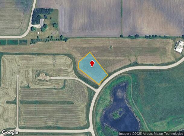
45W748 N Serosun Farms Ln, Hampshire, IL 60140
This Property Is For Sale
NEARBY LISTINGS FOR SALE OR LEASE
Property Detail
45W748 N Serosun Farms Ln
Chicago-Naperville-Elgin, IL-IN-WI
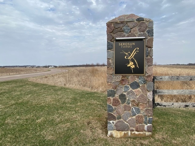
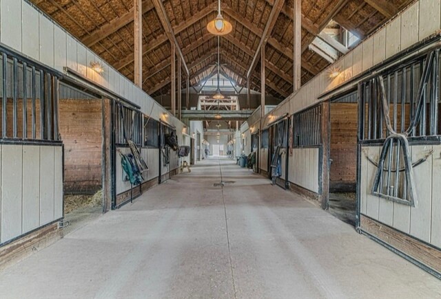
Serosun Farms Estate
04-01-101-007
SEROSUN FARMS ESTATE PHASE 1 LOT 48
Recreationalacreage
Kane
X
Illinois
17089C0109J
48
2024
0.95 AC
2024
Western East/West Corr
850703
Chicago
DEMOGRAPHICS near 45W748 N Serosun Farms Ln
1 Mile
3 Mile
5 Mile
2024 Total Population
203
8,866
23,282
2029 Population
189
8,890
23,464
Pop Growth 2024-2029
(6.90%)
+ 0.27%
+ 0.78%
Average Age
43
39
39
2024 Total Households
74
3,171
8,176
HH Growth 2024-2029
(8.11%)
+ 0.13%
+ 0.77%
Median Household Inc
$119,317
$101,923
$116,762
Avg Household Size
2.80
2.80
2.80
2024 Avg HH Vehicles
3.00
2.00
2.00
Median Home Value
$445,833
$328,157
$340,428
Median Year Built
1985
1998
2004
Nearby Places
- Restaurants
- Banks
- Shops
- Fitness
- Groceries
PUBLIC TRANSPORTATION
AIRPORT
Chicago O'Hare International
DRIVE
WALK
Distance
Chicago O'Hare International
75 min
43.8 mi
Chicago/Rockford International
DRIVE
WALK
Distance
Chicago/Rockford International
68 min
44.5 mi
Nearby Properties
Address
Land Use
TOTAL SIZE
Lot Size
Zoning
Address
Land Use
TOTAL SIZE
Lot Size
Zoning
152,275 SF
12.22 AC
I DISTRICT
Address
Land Use
TOTAL SIZE
Lot Size
Zoning
44,800 SF
35.39 AC
M2 MANUFAC
Address
Land Use
TOTAL SIZE
Lot Size
Zoning
1.75 AC
Address
Land Use
TOTAL SIZE
Lot Size
Zoning
101,250 SF
17.98 AC
Address
Land Use
TOTAL SIZE
Lot Size
Zoning
Address
Land Use
TOTAL SIZE
Lot Size
Zoning
Address
Land Use
TOTAL SIZE
Lot Size
Zoning
Address
Land Use
TOTAL SIZE
Lot Size
Zoning
55,292 SF
3.58 AC
Address
Land Use
TOTAL SIZE
Lot Size
Zoning
Address
Land Use
TOTAL SIZE
Lot Size
Zoning
162,846 SF
4.71 AC
Address
Land Use
TOTAL SIZE
Lot Size
Zoning
28,900 SF
9 AC
I DISTRICT
Address
Land Use
TOTAL SIZE
Lot Size
Zoning
23,626 SF
1.98 AC
I DISTRICT
Address
Land Use
TOTAL SIZE
Lot Size
Zoning
4.83 AC
Address
Land Use
TOTAL SIZE
Lot Size
Zoning
46,596 SF
5.66 AC
M1 MANUFAC
Address
Land Use
TOTAL SIZE
Lot Size
Zoning
29,863 SF
3.27 AC
I DISTRICT
Address
Land Use
TOTAL SIZE
Lot Size
Zoning
3.81 AC
Address
Land Use
TOTAL SIZE
Lot Size
Zoning
30,607 SF
2.36 AC
B1 DISTRIC
Address
Land Use
TOTAL SIZE
Lot Size
Zoning
23,754 SF
1.87 AC
I DISTRICT
Address
Land Use
TOTAL SIZE
Lot Size
Zoning
1.16 AC
Address
Land Use
TOTAL SIZE
Lot Size
Zoning
18,317 SF
2.06 AC
B2 DISTRIC
Address
Land Use
TOTAL SIZE
Lot Size
Zoning
18,080 SF
1.93 AC
M1 MANUFAC
Address
Land Use
TOTAL SIZE
Lot Size
Zoning
34,215 SF
2.64 AC
B2 DISTRIC
Address
Land Use
TOTAL SIZE
Lot Size
Zoning
1.79 AC
Address
Land Use
TOTAL SIZE
Lot Size
Zoning
43,300 SF
1.81 AC
B2 DISTRIC
Address
Land Use
TOTAL SIZE
Lot Size
Zoning
72,000 SF
2.07 AC
B2 DISTRIC
Address
Land Use
TOTAL SIZE
Lot Size
Zoning
18,000 SF
4.62 AC
Address
Land Use
TOTAL SIZE
Lot Size
Zoning
2,098 SF
100 AC
F DISTRICT
Address
Land Use
TOTAL SIZE
Lot Size
Zoning
3,151 SF
2.52 AC
B3 DISTRIC
Address
Land Use
TOTAL SIZE
Lot Size
Zoning
3,339 SF
0.95 AC
B2 DISTRIC
The World's #1 Commercial Real Estate Marketplace
Connect with us
© 2025 CoStar Group
The information above has been obtained from sources believed reliable. While we do not doubt its accuracy we have not verified it and make no guarantee, warranty or representation about it. It is your responsibility to independently confirm its accuracy and completeness. Any projections, opinions, assumptions, or estimates used are for example only and do not represent the current or future performance of the property. The value of this transaction to you depends on tax and other factors which should be evaluated by your tax, financial, and legal advisors. You and your advisors should conduct a careful, independent investigation of the property to determine to your satisfaction the suitability of the property for your needs.