Property Record
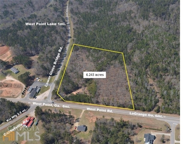
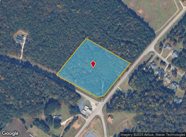
Lower Glass Bridge Rd, Lagrange, GA 30240

NEARBY LISTINGS FOR SALE OR LEASE
Property Detail
Lower Glass Bridge Rd
LaGrange, GA-AL
LOWER GLASS BRIDGE RD/ B24-PG1
078-0-000-010
Troup
Commercialacreage
Georgia
X
214
13285C0210F
6.24 AC
2024
Troup County
2025
Columbus GA
960300
DEMOGRAPHICS near Lower Glass Bridge Rd
1 Mile
3 Mile
5 Mile
2024 Total Population
208
1,828
8,013
2029 Population
212
1,857
8,077
Pop Growth 2024-2029
+ 1.92%
+ 1.59%
+ 0.80%
Average Age
40
40
40
2024 Total Households
79
684
3,024
HH Growth 2024-2029
+ 2.53%
+ 1.75%
+ 0.83%
Median Household Inc
$49,687
$53,846
$64,331
Avg Household Size
2.50
2.60
2.60
2024 Avg HH Vehicles
2.00
3.00
2.00
Median Home Value
$156,666
$222,059
$192,294
Median Year Built
1982
1991
1989
Nearby Places
Map Layers
Map Styles
 Street
 Aerial
- Restaurants
- Banks
- Shops
- Fitness
- Groceries
PUBLIC TRANSPORTATION
AIRPORT
Columbus
DRIVE
WALK
Distance
Columbus
54 min
40.2 mi
SALE & LEASE HISTORY
LISTING DATE
SALE/LEASE

Oct 02, 2019
For Sale
Nov 28, 2017
For Sale
Jul 25, 2017
For Sale
Nearby Properties
Address
Land Use
TOTAL SIZE
Lot Size
Zoning
Address
Land Use
TOTAL SIZE
Lot Size
Zoning
415,440 SF
2,257.11 AC
17-I-1
Address
Land Use
TOTAL SIZE
Lot Size
Zoning
154,930 SF
73.75 AC
01-SFMD
Address
Land Use
TOTAL SIZE
Lot Size
Zoning
70,000 SF
7.36 AC
17-I-1
Address
Land Use
TOTAL SIZE
Lot Size
Zoning
160.49 AC
17-R-1
Address
Land Use
TOTAL SIZE
Lot Size
Zoning
75,684 SF
5.28 AC
17-MXD-1
Address
Land Use
TOTAL SIZE
Lot Size
Zoning
63,804 SF
8.60 AC
17-MXD-1
Address
Land Use
TOTAL SIZE
Lot Size
Zoning
57.63 AC
01-SFMD
Address
Land Use
TOTAL SIZE
Lot Size
Zoning
62,262 SF
25 AC
01-SFMD
Address
Land Use
TOTAL SIZE
Lot Size
Zoning
7,310 SF
6 AC
17-CGN
Address
Land Use
TOTAL SIZE
Lot Size
Zoning
29,327 SF
1.13 AC
17-MXD-1
Address
Land Use
TOTAL SIZE
Lot Size
Zoning
117.38 AC
17-R-1
Address
Land Use
TOTAL SIZE
Lot Size
Zoning
70.58 AC
17-CGN
Address
Land Use
TOTAL SIZE
Lot Size
Zoning
22.17 AC
17-CGN
Address
Land Use
TOTAL SIZE
Lot Size
Zoning
19,008 SF
1.10 AC
17-MXD-1
Address
Land Use
TOTAL SIZE
Lot Size
Zoning
29,327 SF
64.91 AC
17-MXD-1
Address
Land Use
TOTAL SIZE
Lot Size
Zoning
307.19 AC
16- CP-GI
Address
Land Use
TOTAL SIZE
Lot Size
Zoning
8,820 SF
1.57 AC
17-CGN
Address
Land Use
TOTAL SIZE
Lot Size
Zoning
11,019 SF
2 AC
01-GC
Address
Land Use
TOTAL SIZE
Lot Size
Zoning
64.83 AC
01-SFMD
Address
Land Use
TOTAL SIZE
Lot Size
Zoning
13.04 AC
17-CGN
Address
Land Use
TOTAL SIZE
Lot Size
Zoning
12.09 AC
17-CGN
Address
Land Use
TOTAL SIZE
Lot Size
Zoning
251.65 AC
01-SPLIT
Address
Land Use
TOTAL SIZE
Lot Size
Zoning
5,654 SF
1.24 AC
01-SFMD
Address
Land Use
TOTAL SIZE
Lot Size
Zoning
8.95 AC
17-CGN
Address
Land Use
TOTAL SIZE
Lot Size
Zoning
34.22 AC
17-CGN
Address
Land Use
TOTAL SIZE
Lot Size
Zoning
222.21 AC
17-MXD-1
Address
Land Use
TOTAL SIZE
Lot Size
Zoning
10 AC
17-CGN
Address
Land Use
TOTAL SIZE
Lot Size
Zoning
83.68 AC
01-SFMD
Address
Land Use
TOTAL SIZE
Lot Size
Zoning
3,133 SF
166.59 AC
01-AGR
Address
Land Use
TOTAL SIZE
Lot Size
Zoning
254 AC
01-SFMD
The World's #1 Commercial Real Estate Marketplace
Connect with us
© 2026 CoStar Group
The information above has been obtained from sources believed reliable. While we do not doubt its accuracy we have not verified it and make no guarantee, warranty or representation about it. It is your responsibility to independently confirm its accuracy and completeness. Any projections, opinions, assumptions, or estimates used are for example only and do not represent the current or future performance of the property. The value of this transaction to you depends on tax and other factors which should be evaluated by your tax, financial, and legal advisors. You and your advisors should conduct a careful, independent investigation of the property to determine to your satisfaction the suitability of the property for your needs.