No Photo
Property Record
Lower Lost Prairie Rd, Marion, MT 59925


NEARBY LISTINGS FOR SALE OR LEASE
-
-
View all Marion listings for sale on LoopNet.com
Property Detail
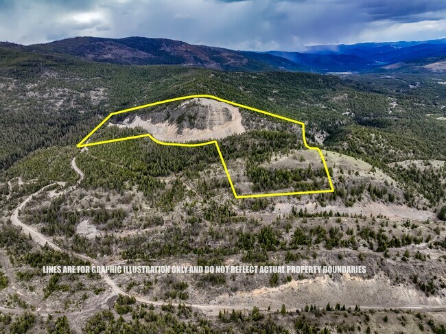
Lower Lost Prairie Rd
07-3830-04-4-01-01-0000
S04, T27 N, R24 W, C.O.S. 17398-PT, ACRES 118.94, TR 5 IN N2SE4 & L9 LESS ROADS
Agriculturalland
Flathead
X
Montana
30029C1750G
118.94 AC
2025
Glacier Country
2025
Other Market Areas
001703
Kalispell, MT
DEMOGRAPHICS near Lower Lost Prairie Rd
1 Mile
3 Mile
5 Mile
2024 Total Population
37
782
1,164
2029 Population
41
878
1,308
Pop Growth 2024-2029
+ 10.81%
+ 12.28%
+ 12.37%
Average Age
44
44
44
2024 Total Households
15
308
456
HH Growth 2024-2029
+ 6.67%
+ 12.01%
+ 12.06%
Median Household Inc
$57,499
$58,905
$58,863
Avg Household Size
2.20
2.50
2.50
2024 Avg HH Vehicles
2.00
2.00
2.00
Median Home Value
$387,499
$410,000
$436,842
Median Year Built
1991
1991
1991
Nearby Places
Map Layers
Map Styles
 Street
 Aerial
- Restaurants
- Banks
- Shops
- Fitness
- Groceries
PUBLIC TRANSPORTATION
AIRPORT
Glacier Park International
DRIVE
WALK
Distance
Glacier Park International
55 min
34.8 mi
Freight Ports
Port of Everett
DRIVE
WALK
Distance
Port of Everett
619 min
530.1 mi
SALE & LEASE HISTORY
LISTING DATE
SALE/LEASE

Jun 05, 2024
For Sale
Nearby Properties
Address
Land Use
TOTAL SIZE
Lot Size
Zoning
Address
Land Use
TOTAL SIZE
Lot Size
Zoning
10.01 AC
Address
Land Use
TOTAL SIZE
Lot Size
Zoning
19,700 SF
22.30 AC
Address
Land Use
TOTAL SIZE
Lot Size
Zoning
3,904 SF
3.11 AC
Address
Land Use
TOTAL SIZE
Lot Size
Zoning
364 SF
12.19 AC
Address
Land Use
TOTAL SIZE
Lot Size
Zoning
5,963 SF
1.81 AC
Address
Land Use
TOTAL SIZE
Lot Size
Zoning
4.65 AC
Address
Land Use
TOTAL SIZE
Lot Size
Zoning
4.56 AC
Address
Land Use
TOTAL SIZE
Lot Size
Zoning
1,908 SF
0.98 AC
Address
Land Use
TOTAL SIZE
Lot Size
Zoning
3.77 AC
Address
Land Use
TOTAL SIZE
Lot Size
Zoning
224 SF
6.97 AC
Address
Land Use
TOTAL SIZE
Lot Size
Zoning
2.66 AC
Address
Land Use
TOTAL SIZE
Lot Size
Zoning
420 SF
0.46 AC
Address
Land Use
TOTAL SIZE
Lot Size
Zoning
500 SF
0.93 AC
Address
Land Use
TOTAL SIZE
Lot Size
Zoning
2.98 AC
Address
Land Use
TOTAL SIZE
Lot Size
Zoning
4,744 SF
60.64 AC
Address
Land Use
TOTAL SIZE
Lot Size
Zoning
3.97 AC
Address
Land Use
TOTAL SIZE
Lot Size
Zoning
2,480 SF
11.97 AC
Address
Land Use
TOTAL SIZE
Lot Size
Zoning
2.50 AC
Address
Land Use
TOTAL SIZE
Lot Size
Zoning
2.09 AC
Address
Land Use
TOTAL SIZE
Lot Size
Zoning
1.07 AC
Address
Land Use
TOTAL SIZE
Lot Size
Zoning
1.85 AC
Address
Land Use
TOTAL SIZE
Lot Size
Zoning
4.77 AC
Address
Land Use
TOTAL SIZE
Lot Size
Zoning
1.10 AC
Address
Land Use
TOTAL SIZE
Lot Size
Zoning
Address
Land Use
TOTAL SIZE
Lot Size
Zoning
1.16 AC
Address
Land Use
TOTAL SIZE
Lot Size
Zoning
1.34 AC
Address
Land Use
TOTAL SIZE
Lot Size
Zoning
1.27 AC
Address
Land Use
TOTAL SIZE
Lot Size
Zoning
Address
Land Use
TOTAL SIZE
Lot Size
Zoning
Address
Land Use
TOTAL SIZE
Lot Size
Zoning
The World's #1 Commercial Real Estate Marketplace
Connect with us
© 2025 CoStar Group
The information above has been obtained from sources believed reliable. While we do not doubt its accuracy we have not verified it and make no guarantee, warranty or representation about it. It is your responsibility to independently confirm its accuracy and completeness. Any projections, opinions, assumptions, or estimates used are for example only and do not represent the current or future performance of the property. The value of this transaction to you depends on tax and other factors which should be evaluated by your tax, financial, and legal advisors. You and your advisors should conduct a careful, independent investigation of the property to determine to your satisfaction the suitability of the property for your needs.