Property Record
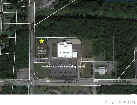
Lynhaven Dr, , NC


NEARBY LISTINGS FOR SALE OR LEASE
-
-
-
-
-
-
-
No Photo
-
View all listings for sale on LoopNet.com
Property Detail
Lynhaven Dr
Charlotte-Concord-Gastonia, NC-SC
Sub Plat For Hudson Corners Llc
209145
HUDSON CORNERS L 2 01 094 002 00 000
Commercialnec
Gaston
X
North Carolina
3710354400J
1.02 AC
2025
Gaston County
2025
Charlotte
033100
DEMOGRAPHICS near Lynhaven Dr
1 Mile
3 Mile
5 Mile
2024 Total Population
7,650
47,370
90,145
2029 Population
8,184
50,742
96,216
Pop Growth 2024-2029
+ 6.98%
+ 7.12%
+ 6.73%
Average Age
37
39
40
2024 Total Households
2,825
18,926
35,954
HH Growth 2024-2029
+ 7.15%
+ 7.24%
+ 6.89%
Median Household Inc
$37,559
$40,182
$47,183
Avg Household Size
2.60
2.40
2.40
2024 Avg HH Vehicles
2.00
2.00
2.00
Median Home Value
$153,240
$156,779
$180,019
Median Year Built
1966
1971
1976
Nearby Places
Map Layers
Map Styles
 Street
 Aerial
- Restaurants
- Banks
- Shops
- Fitness
- Groceries
PUBLIC TRANSPORTATION
COMMUTER RAIL
DRIVE
WALK
Distance
9 min
4.6 mi
AIRPORT
Charlotte/Douglas International
DRIVE
WALK
Distance
Charlotte/Douglas International
37 min
20.1 mi
Concord-Padgett Regional
DRIVE
WALK
Distance
Concord-Padgett Regional
50 min
36.5 mi
SALE & LEASE HISTORY
LISTING DATE
SALE/LEASE

Jan 28, 2021
For Sale
Nearby Properties
Address
Land Use
TOTAL SIZE
Lot Size
Zoning
Address
Land Use
TOTAL SIZE
Lot Size
Zoning
56,000 SF
23.22 AC
GOV01
Address
Land Use
TOTAL SIZE
Lot Size
Zoning
4,519 SF
2.10 AC
Address
Land Use
TOTAL SIZE
Lot Size
Zoning
159,263 SF
9.83 AC
GOV01
Address
Land Use
TOTAL SIZE
Lot Size
Zoning
17.37 AC
Address
Land Use
TOTAL SIZE
Lot Size
Zoning
2,066 SF
16.10 AC
Address
Land Use
TOTAL SIZE
Lot Size
Zoning
1,886 SF
13.27 AC
APT01
Address
Land Use
TOTAL SIZE
Lot Size
Zoning
1,602 SF
14.02 AC
APT02
Address
Land Use
TOTAL SIZE
Lot Size
Zoning
9,792 SF
14.31 AC
APT01
Address
Land Use
TOTAL SIZE
Lot Size
Zoning
192,978 SF
22.67 AC
RET05
Address
Land Use
TOTAL SIZE
Lot Size
Zoning
123,948 SF
6.94 AC
GOV05
Address
Land Use
TOTAL SIZE
Lot Size
Zoning
0.79 AC
RET01
Address
Land Use
TOTAL SIZE
Lot Size
Zoning
112,513 SF
13.09 AC
PUB01
Address
Land Use
TOTAL SIZE
Lot Size
Zoning
1,721 SF
17.49 AC
OFF01
Address
Land Use
TOTAL SIZE
Lot Size
Zoning
8,412 SF
39.83 AC
PUB01
Address
Land Use
TOTAL SIZE
Lot Size
Zoning
14.51 AC
Address
Land Use
TOTAL SIZE
Lot Size
Zoning
5,880 SF
10.17 AC
APT01
Address
Land Use
TOTAL SIZE
Lot Size
Zoning
1,760 SF
3.51 AC
Address
Land Use
TOTAL SIZE
Lot Size
Zoning
104,144 SF
13.69 AC
OFF04
Address
Land Use
TOTAL SIZE
Lot Size
Zoning
44,794 SF
46.96 AC
PUB01
Address
Land Use
TOTAL SIZE
Lot Size
Zoning
57,880 SF
5.99 AC
GOV05
Address
Land Use
TOTAL SIZE
Lot Size
Zoning
11,676 SF
7.31 AC
Address
Land Use
TOTAL SIZE
Lot Size
Zoning
1,200 SF
7.58 AC
APT02
Address
Land Use
TOTAL SIZE
Lot Size
Zoning
109,085 SF
1.69 AC
BANK1
Address
Land Use
TOTAL SIZE
Lot Size
Zoning
1,471 SF
8.96 AC
OFF01
Address
Land Use
TOTAL SIZE
Lot Size
Zoning
64,332 SF
32.20 AC
Address
Land Use
TOTAL SIZE
Lot Size
Zoning
12.25 AC
Address
Land Use
TOTAL SIZE
Lot Size
Zoning
78,004 SF
5.72 AC
APT01
Address
Land Use
TOTAL SIZE
Lot Size
Zoning
6,608 SF
9.10 AC
Address
Land Use
TOTAL SIZE
Lot Size
Zoning
5,432 SF
7.61 AC
APT02
Address
Land Use
TOTAL SIZE
Lot Size
Zoning
1,746 SF
15.31 AC
The World's #1 Commercial Real Estate Marketplace
Connect with us
© 2026 CoStar Group
The information above has been obtained from sources believed reliable. While we do not doubt its accuracy we have not verified it and make no guarantee, warranty or representation about it. It is your responsibility to independently confirm its accuracy and completeness. Any projections, opinions, assumptions, or estimates used are for example only and do not represent the current or future performance of the property. The value of this transaction to you depends on tax and other factors which should be evaluated by your tax, financial, and legal advisors. You and your advisors should conduct a careful, independent investigation of the property to determine to your satisfaction the suitability of the property for your needs.