Property Record
M-52 Highway, Manchester, MI 48158

NEARBY LISTINGS FOR SALE OR LEASE
-
-
View all Manchester listings for sale on LoopNet.com
Property Detail
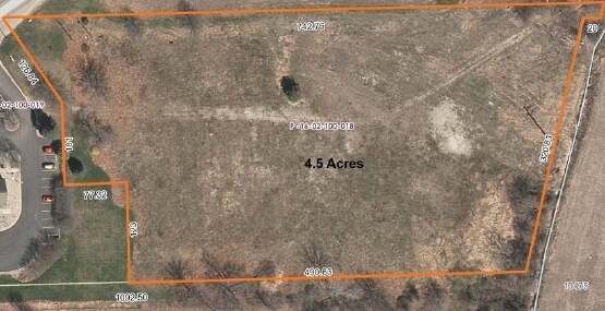
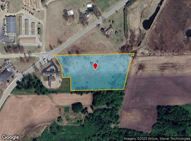
M-52 Highway
16-02-100-018
OWNER REQUEST MA 2-1A PCL A COM AT N 1/4 COR SEC 2
Commercialacreage
Washtenaw
X
Michigan
26161C0341E
4.50 AC
2025
Washtenaw W of 23
2025
Detroit
431000
Ann Arbor, MI
DEMOGRAPHICS near M-52 Highway
1 Mile
3 Mile
5 Mile
2024 Total Population
1,517
3,721
6,081
2029 Population
1,496
3,647
5,966
Pop Growth 2024-2029
(1.38%)
(1.99%)
(1.89%)
Average Age
44
45
45
2024 Total Households
685
1,600
2,520
HH Growth 2024-2029
(1.46%)
(2.06%)
(2.02%)
Median Household Inc
$70,049
$81,504
$86,509
Avg Household Size
2.20
2.30
2.40
2024 Avg HH Vehicles
2.00
2.00
2.00
Median Home Value
$205,734
$252,441
$280,763
Median Year Built
1977
1976
1976
Nearby Places
Map Layers
Map Styles
 Street
 Aerial
- Restaurants
- Banks
- Shops
- Fitness
- Groceries
SALE & LEASE HISTORY
LISTING DATE
SALE/LEASE

Jan 23, 2017
For Sale
Nearby Properties
Address
Land Use
TOTAL SIZE
Lot Size
Zoning
Address
Land Use
TOTAL SIZE
Lot Size
Zoning
89,091 SF
8.36 AC
I-2 GEN
Address
Land Use
TOTAL SIZE
Lot Size
Zoning
231,551 SF
20.94 AC
I-2 GEN
Address
Land Use
TOTAL SIZE
Lot Size
Zoning
5,805 SF
56.76 AC
AR AGR
Address
Land Use
TOTAL SIZE
Lot Size
Zoning
78,345 SF
7.32 AC
CM COMM
Address
Land Use
TOTAL SIZE
Lot Size
Zoning
2,881 SF
61.48 AC
AG AGR
Address
Land Use
TOTAL SIZE
Lot Size
Zoning
180 SF
18.96 AC
AG AGR
Address
Land Use
TOTAL SIZE
Lot Size
Zoning
18,824 SF
5.35 AC
BI
Address
Land Use
TOTAL SIZE
Lot Size
Zoning
22,701 SF
AG AGR
Address
Land Use
TOTAL SIZE
Lot Size
Zoning
19,570 SF
9.23 AC
I-2 GEN
Address
Land Use
TOTAL SIZE
Lot Size
Zoning
37 AC
R-1B SI
Address
Land Use
TOTAL SIZE
Lot Size
Zoning
28,172 SF
4.31 AC
R-2B MU
Address
Land Use
TOTAL SIZE
Lot Size
Zoning
1,825 SF
AG
Address
Land Use
TOTAL SIZE
Lot Size
Zoning
43,197 SF
4.20 AC
I-3 URB
Address
Land Use
TOTAL SIZE
Lot Size
Zoning
8,946 SF
2.92 AC
C-2 GEN
Address
Land Use
TOTAL SIZE
Lot Size
Zoning
2,409 SF
110.78 AC
AG
Address
Land Use
TOTAL SIZE
Lot Size
Zoning
2,525 SF
50.61 AC
AG
Address
Land Use
TOTAL SIZE
Lot Size
Zoning
1,892 SF
120.81 AC
AG
Address
Land Use
TOTAL SIZE
Lot Size
Zoning
8,256 SF
11 AC
Address
Land Use
TOTAL SIZE
Lot Size
Zoning
2,671 SF
145.40 AC
AG
Address
Land Use
TOTAL SIZE
Lot Size
Zoning
3,900 SF
40 AC
BI
Address
Land Use
TOTAL SIZE
Lot Size
Zoning
7,212 SF
1.90 AC
R-1B SI
Address
Land Use
TOTAL SIZE
Lot Size
Zoning
163,282 SF
15.39 AC
I-2 GEN
Address
Land Use
TOTAL SIZE
Lot Size
Zoning
16,000 SF
1.90 AC
C-2 GEN
Address
Land Use
TOTAL SIZE
Lot Size
Zoning
17,783 SF
2.22 AC
R-3 MUL
Address
Land Use
TOTAL SIZE
Lot Size
Zoning
3,120 SF
7.42 AC
CC COMM
Address
Land Use
TOTAL SIZE
Lot Size
Zoning
2,296 SF
2.38 AC
CC COMM
Address
Land Use
TOTAL SIZE
Lot Size
Zoning
2,086 SF
5.06 AC
AR AGR
Address
Land Use
TOTAL SIZE
Lot Size
Zoning
3,372 SF
3.09 AC
AG
Address
Land Use
TOTAL SIZE
Lot Size
Zoning
The World's #1 Commercial Real Estate Marketplace
Connect with us
© 2025 CoStar Group
The information above has been obtained from sources believed reliable. While we do not doubt its accuracy we have not verified it and make no guarantee, warranty or representation about it. It is your responsibility to independently confirm its accuracy and completeness. Any projections, opinions, assumptions, or estimates used are for example only and do not represent the current or future performance of the property. The value of this transaction to you depends on tax and other factors which should be evaluated by your tax, financial, and legal advisors. You and your advisors should conduct a careful, independent investigation of the property to determine to your satisfaction the suitability of the property for your needs.