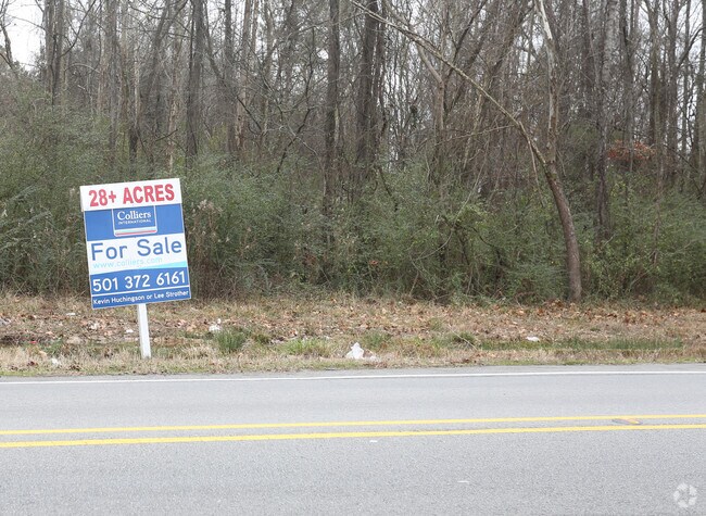
Property Record
Mabelvale West Rd, Little Rock, AR 72103
NEARBY LISTINGS FOR SALE OR LEASE
-
-
-
No Photo
-
Mabelvale West Road And Otter Creek East Blvd @ Otter Creek East Blvd
Mabelvale, AR 72103
$590,000
1.01 AC Lots
Land
-
-
-
View all Little Rock listings for sale on LoopNet.com
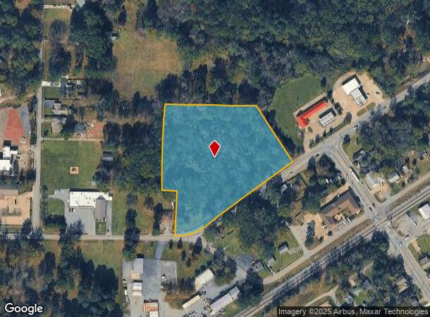
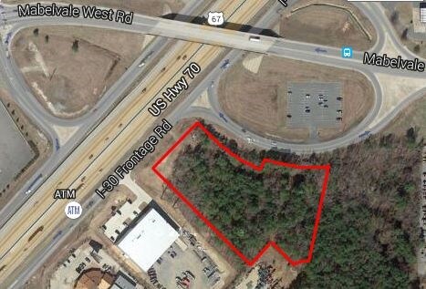
Property Detail
Mabelvale West Rd
Little Rock-North Little Rock-Conway, AR
Mabelvale
45L-045-00-083-00
PT SE SW COM SW COR SE SW TH AL CLN MABELVALE WEST RD E630 FOR POB TH N220 S87*16W43.6N13*11W112.9 N5*1237W290.03 N88*1528E66.4 N88*45E392.8 S32*E315 TO N R/W MABELVALE WEST RD S54*W510 MOL TH S56*W90 MOL TH S78*W45 MOL TO POB 3 1S 13W
Residentialacreage
Pulaski
AE
Arkansas
05125C0250E
5.73 AC
2025
Outlying Pulaski County
2025
Little Rock/N Little Rock
010409
DEMOGRAPHICS near Mabelvale West Rd
1 Mile
3 Mile
5 Mile
2024 Total Population
1,745
34,524
80,430
2029 Population
1,754
34,622
81,724
Pop Growth 2024-2029
+ 0.52%
+ 0.28%
+ 1.61%
Average Age
36
36
36
2024 Total Households
685
13,648
31,183
HH Growth 2024-2029
+ 0.44%
+ 0.18%
+ 1.49%
Median Household Inc
$43,396
$49,148
$49,037
Avg Household Size
2.50
2.50
2.50
2024 Avg HH Vehicles
2.00
2.00
2.00
Median Home Value
$126,948
$142,950
$137,305
Median Year Built
1977
1984
1981
Nearby Places
Map Layers
Map Styles
 Street
 Aerial
- Restaurants
- Banks
- Shops
- Fitness
- Groceries
PUBLIC TRANSPORTATION
AIRPORT
Bill and Hillary Clinton Ntl/Adams Field
DRIVE
WALK
Distance
Bill and Hillary Clinton Ntl/Adams Field
17 min
12.4 mi
Freight Ports
Port of Shreveport
DRIVE
WALK
Distance
Port of Shreveport
239 min
223.0 mi
SALE & LEASE HISTORY
LISTING DATE
SALE/LEASE

Sep 24, 2016
For Sale
Apr 24, 2017
For Sale
Nearby Properties
Address
Land Use
TOTAL SIZE
Lot Size
Zoning
Address
Land Use
TOTAL SIZE
Lot Size
Zoning
189,729 SF
57.75 AC
Address
Land Use
TOTAL SIZE
Lot Size
Zoning
10 SF
29.02 AC
Address
Land Use
TOTAL SIZE
Lot Size
Zoning
177,413 SF
35.78 AC
Address
Land Use
TOTAL SIZE
Lot Size
Zoning
185,805 SF
8.29 AC
Address
Land Use
TOTAL SIZE
Lot Size
Zoning
317,302 SF
44.38 AC
Address
Land Use
TOTAL SIZE
Lot Size
Zoning
26,199 SF
19.22 AC
Address
Land Use
TOTAL SIZE
Lot Size
Zoning
201,039 SF
146.98 AC
Address
Land Use
TOTAL SIZE
Lot Size
Zoning
13,888 SF
21.57 AC
Address
Land Use
TOTAL SIZE
Lot Size
Zoning
83,022 SF
6.20 AC
Address
Land Use
TOTAL SIZE
Lot Size
Zoning
79,751 SF
28.57 AC
Address
Land Use
TOTAL SIZE
Lot Size
Zoning
365,104 SF
29.75 AC
Address
Land Use
TOTAL SIZE
Lot Size
Zoning
104,359 SF
14.63 AC
Address
Land Use
TOTAL SIZE
Lot Size
Zoning
13,952 SF
12.35 AC
Address
Land Use
TOTAL SIZE
Lot Size
Zoning
41,652 SF
10.86 AC
Address
Land Use
TOTAL SIZE
Lot Size
Zoning
7,937 SF
5.50 AC
Address
Land Use
TOTAL SIZE
Lot Size
Zoning
12,420 SF
12.25 AC
Address
Land Use
TOTAL SIZE
Lot Size
Zoning
201,499 SF
21.70 AC
Address
Land Use
TOTAL SIZE
Lot Size
Zoning
131,278 SF
6.37 AC
Address
Land Use
TOTAL SIZE
Lot Size
Zoning
16,957 SF
6.04 AC
Address
Land Use
TOTAL SIZE
Lot Size
Zoning
24,520 SF
10.92 AC
Address
Land Use
TOTAL SIZE
Lot Size
Zoning
8,510 SF
13.20 AC
Address
Land Use
TOTAL SIZE
Lot Size
Zoning
45,600 SF
6.45 AC
Address
Land Use
TOTAL SIZE
Lot Size
Zoning
189,160 SF
40.53 AC
Address
Land Use
TOTAL SIZE
Lot Size
Zoning
30,356 SF
5.42 AC
Address
Land Use
TOTAL SIZE
Lot Size
Zoning
64,182 SF
17.80 AC
Address
Land Use
TOTAL SIZE
Lot Size
Zoning
71,581 SF
10.69 AC
Address
Land Use
TOTAL SIZE
Lot Size
Zoning
11,762 SF
9.05 AC
Address
Land Use
TOTAL SIZE
Lot Size
Zoning
309,271 SF
41.75 AC
Address
Land Use
TOTAL SIZE
Lot Size
Zoning
85,458 SF
9.86 AC
Address
Land Use
TOTAL SIZE
Lot Size
Zoning
7,482 SF
6.58 AC
The World's #1 Commercial Real Estate Marketplace
Connect with us
© 2025 CoStar Group
The information above has been obtained from sources believed reliable. While we do not doubt its accuracy we have not verified it and make no guarantee, warranty or representation about it. It is your responsibility to independently confirm its accuracy and completeness. Any projections, opinions, assumptions, or estimates used are for example only and do not represent the current or future performance of the property. The value of this transaction to you depends on tax and other factors which should be evaluated by your tax, financial, and legal advisors. You and your advisors should conduct a careful, independent investigation of the property to determine to your satisfaction the suitability of the property for your needs.