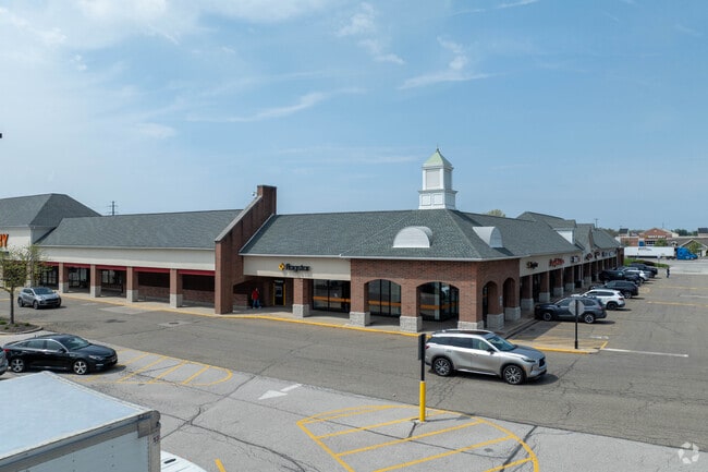
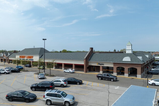
Property Record
Macedonia Commons Blvd, Macedonia, OH 44056
NEARBY LISTINGS FOR SALE OR LEASE
Property Detail
Macedonia Commons Blvd
Akron, OH
Macedonia Commons Subd
33-12308
MACEDONIA COMMONS SUBDN BLK F LESS PT RD
Commercialacreage
Summit
X
Ohio
39035C0335E
1.92 AC
2023
Akron
2025
Cleveland
532701
DEMOGRAPHICS near Macedonia Commons Blvd
1 Mile
3 Mile
5 Mile
2024 Total Population
3,517
32,998
65,304
2029 Population
3,442
32,351
64,021
Pop Growth 2024-2029
(2.13%)
(1.96%)
(1.96%)
Average Age
46
45
44
2024 Total Households
1,509
13,798
26,533
HH Growth 2024-2029
(2.19%)
(2.03%)
(2.02%)
Median Household Inc
$84,360
$93,200
$93,562
Avg Household Size
2.30
2.40
2.40
2024 Avg HH Vehicles
2.00
2.00
2.00
Median Home Value
$244,357
$244,489
$257,120
Median Year Built
1984
1984
1981
Nearby Places
Map Layers
Map Styles
 Street
 Aerial
- Restaurants
- Banks
- Shops
- Fitness
- Groceries
PUBLIC TRANSPORTATION
COMMUTER RAIL
Brecksville (National Park Scenic Railway - Cuyahoga Valley Scenic Railroad)
DRIVE
WALK
Distance
Brecksville (National Park Scenic Railway - Cuyahoga Valley Scenic Railroad)
12 min
4.8 mi
Boston Mill (National Park Scenic Railway - Cuyahoga Valley Scenic Railroad)
DRIVE
WALK
Distance
Boston Mill (National Park Scenic Railway - Cuyahoga Valley Scenic Railroad)
13 min
7.3 mi
AIRPORT
Cleveland-Hopkins International
DRIVE
WALK
Distance
Cleveland-Hopkins International
38 min
26.8 mi
Akron-Canton Regional
DRIVE
WALK
Distance
Akron-Canton Regional
40 min
30.4 mi
Freight Ports
Port of Toledo
DRIVE
WALK
Distance
Port of Toledo
148 min
126.8 mi
SALE & LEASE HISTORY
LISTING DATE
SALE/LEASE

Sep 25, 2016
For Lease
Sep 11, 2017
For Lease
Jul 18, 2017
For Lease
Nearby Properties
Address
Land Use
TOTAL SIZE
Lot Size
Zoning
Address
Land Use
TOTAL SIZE
Lot Size
Zoning
Address
Land Use
TOTAL SIZE
Lot Size
Zoning
49.31 AC
Address
Land Use
TOTAL SIZE
Lot Size
Zoning
315,935 SF
44.94 AC
Address
Land Use
TOTAL SIZE
Lot Size
Zoning
Address
Land Use
TOTAL SIZE
Lot Size
Zoning
270,968 SF
21.68 AC
Address
Land Use
TOTAL SIZE
Lot Size
Zoning
109.65 AC
MUD
Address
Land Use
TOTAL SIZE
Lot Size
Zoning
230,501 SF
39.59 AC
Address
Land Use
TOTAL SIZE
Lot Size
Zoning
155,897 SF
19.81 AC
Address
Land Use
TOTAL SIZE
Lot Size
Zoning
254,828 SF
15.41 AC
Address
Land Use
TOTAL SIZE
Lot Size
Zoning
418,992 SF
27.87 AC
Address
Land Use
TOTAL SIZE
Lot Size
Zoning
210,136 SF
21.69 AC
Address
Land Use
TOTAL SIZE
Lot Size
Zoning
Address
Land Use
TOTAL SIZE
Lot Size
Zoning
130,822 SF
17.50 AC
Address
Land Use
TOTAL SIZE
Lot Size
Zoning
136,800 SF
7.86 AC
Address
Land Use
TOTAL SIZE
Lot Size
Zoning
320,818 SF
12 AC
Address
Land Use
TOTAL SIZE
Lot Size
Zoning
105,438 SF
9.59 AC
Address
Land Use
TOTAL SIZE
Lot Size
Zoning
60,908 SF
46.85 AC
Address
Land Use
TOTAL SIZE
Lot Size
Zoning
204,490 SF
14.52 AC
Address
Land Use
TOTAL SIZE
Lot Size
Zoning
99,400 SF
3.96 AC
Address
Land Use
TOTAL SIZE
Lot Size
Zoning
85,808 SF
10.20 AC
Address
Land Use
TOTAL SIZE
Lot Size
Zoning
Address
Land Use
TOTAL SIZE
Lot Size
Zoning
Address
Land Use
TOTAL SIZE
Lot Size
Zoning
211,548 SF
14.01 AC
Address
Land Use
TOTAL SIZE
Lot Size
Zoning
14,247 SF
262 AC
Address
Land Use
TOTAL SIZE
Lot Size
Zoning
Address
Land Use
TOTAL SIZE
Lot Size
Zoning
227,086 SF
16.65 AC
IG
Address
Land Use
TOTAL SIZE
Lot Size
Zoning
Address
Land Use
TOTAL SIZE
Lot Size
Zoning
113,882 SF
24.09 AC
Address
Land Use
TOTAL SIZE
Lot Size
Zoning
141,290 SF
11.53 AC
Address
Land Use
TOTAL SIZE
Lot Size
Zoning
163,307 SF
9.90 AC
The World's #1 Commercial Real Estate Marketplace
Connect with us
© 2026 CoStar Group
The information above has been obtained from sources believed reliable. While we do not doubt its accuracy we have not verified it and make no guarantee, warranty or representation about it. It is your responsibility to independently confirm its accuracy and completeness. Any projections, opinions, assumptions, or estimates used are for example only and do not represent the current or future performance of the property. The value of this transaction to you depends on tax and other factors which should be evaluated by your tax, financial, and legal advisors. You and your advisors should conduct a careful, independent investigation of the property to determine to your satisfaction the suitability of the property for your needs.