Property Record
Madera Cir, El Cerrito, CA 94530


Save to a Folder
{{folder.Name}}
{{folder.ListingIds.length}} Properties
{{folder.ListingIds.length}} Property
Create a New Folder
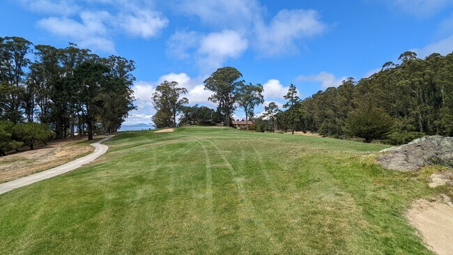
This Property Is For Sale
Property Detail
Madera Cir
Oakland-Fremont-Berkeley, CA
T6985 L5
505-470-005-8
CONTRA COSTA
Recreationalacreage
California
B and X Area of moderate flood hazard, usually the area between the limits of the 100-year and 500-year floods.
5
2025
0.57 AC
2026
Richmond/San Pablo
387000
East Bay/Oakland
NEARBY LISTINGS FOR SALE OR LEASE
DEMOGRAPHICS near Madera Cir
1 mile
3 mile
5 mile
2025 Total Population
12,288
132,996
333,066
2030 Population
12,358
133,524
334,686
Pop Growth 2025-2030
+ 0.57%
+ 0.40%
+ 0.49%
Average Age
45
42
40
2025 Total Households
4,899
48,775
117,716
HH Growth 2025-2030
+ 0.57%
+ 0.37%
+ 0.54%
Median Household Inc
$139,025
$115,218
$100,119
Avg Household Size
2.50
2.60
2.60
2025 Avg HH Vehicles
2.00
2.00
2.00
Median Home Value
$1,058,309
$912,727
$869,812
Median Year Built
1956
1955
1959
Nearby Places
Map Layers
Map Styles
 Street
 Aerial
Layers
 Traffic
 Biking
Places
Listings with unknown addresses are not visible on the map
- Restaurants
- Banks
- Shops
- Fitness
- Groceries
PUBLIC TRANSPORTATION
COMMUTER RAIL
Richmond (Capitol Corridor - Capitol Corridor Joint Powers Authority)
Drive
Walk
Distance
Richmond (Capitol Corridor - Capitol Corridor Joint Powers Authority)
10 min
4.3 mi
Berkeley Amtrak (Capitol Corridor - Amtrak)
Drive
Walk
Distance
Berkeley Amtrak (Capitol Corridor - Amtrak)
10 min
5.9 mi
AIRPORT
Metro Oakland International
Drive
Walk
Distance
Metro Oakland International
30 min
20.8 mi
San Francisco International
Drive
Walk
Distance
San Francisco International
43 min
28.4 mi
Freight Ports
Port of Richmond
Drive
Walk
Distance
Port of Richmond
17 min
7.5 mi
Nearby Properties
Address
Land Use
TOTAL SIZE
Lot Size
Zoning
Address
Land Use
TOTAL SIZE
Lot Size
Zoning
820,000 SF
6.36 AC
Address
Land Use
TOTAL SIZE
Lot Size
Zoning
195,281 SF
0.96 AC
Address
Land Use
TOTAL SIZE
Lot Size
Zoning
163,721 SF
0.76 AC
Address
Land Use
TOTAL SIZE
Lot Size
Zoning
202,811 SF
10.98 AC
Address
Land Use
TOTAL SIZE
Lot Size
Zoning
191,800 SF
1.09 AC
Address
Land Use
TOTAL SIZE
Lot Size
Zoning
69,949 SF
0.65 AC
C2 CD
Address
Land Use
TOTAL SIZE
Lot Size
Zoning
124,257 SF
2.72 AC
Address
Land Use
TOTAL SIZE
Lot Size
Zoning
404,098 SF
24.03 AC
MSL1RD
Address
Land Use
TOTAL SIZE
Lot Size
Zoning
81,352 SF
5.06 AC
C2
Address
Land Use
TOTAL SIZE
Lot Size
Zoning
54,728 SF
0.96 AC
Address
Land Use
TOTAL SIZE
Lot Size
Zoning
117,482 SF
8.68 AC
Address
Land Use
TOTAL SIZE
Lot Size
Zoning
147,500 SF
9.84 AC
Address
Land Use
TOTAL SIZE
Lot Size
Zoning
60,196 SF
13.44 AC
Address
Land Use
TOTAL SIZE
Lot Size
Zoning
136,648 SF
13.27 AC
Address
Land Use
TOTAL SIZE
Lot Size
Zoning
85,225 SF
8.34 AC
Address
Land Use
TOTAL SIZE
Lot Size
Zoning
137,293 SF
10.52 AC
Address
Land Use
TOTAL SIZE
Lot Size
Zoning
107,100 SF
27.35 AC
Address
Land Use
TOTAL SIZE
Lot Size
Zoning
113,960 SF
6 AC
Address
Land Use
TOTAL SIZE
Lot Size
Zoning
67,968 SF
5.62 AC
Address
Land Use
TOTAL SIZE
Lot Size
Zoning
10.90 AC
Address
Land Use
TOTAL SIZE
Lot Size
Zoning
53,498 SF
5.87 AC
M2
Address
Land Use
TOTAL SIZE
Lot Size
Zoning
70,275 SF
1.30 AC
Address
Land Use
TOTAL SIZE
Lot Size
Zoning
53,000 SF
3.74 AC
Address
Land Use
TOTAL SIZE
Lot Size
Zoning
12,707 SF
4.08 AC
Address
Land Use
TOTAL SIZE
Lot Size
Zoning
6,880 SF
3.45 AC
Address
Land Use
TOTAL SIZE
Lot Size
Zoning
167,992 SF
7.54 AC
Address
Land Use
TOTAL SIZE
Lot Size
Zoning
67,290 SF
0.49 AC
Address
Land Use
TOTAL SIZE
Lot Size
Zoning
36,757 SF
1.35 AC
Address
Land Use
TOTAL SIZE
Lot Size
Zoning
104,713 SF
2.04 AC
Address
Land Use
TOTAL SIZE
Lot Size
Zoning
156,960 SF
6.92 AC
The World's #1 Commercial Real Estate Marketplace
Connect with us
© 2026 CoStar Group
The information above has been obtained from sources believed reliable. While we do not doubt its accuracy we have not verified it and make no guarantee, warranty or representation about it. It is your responsibility to independently confirm its accuracy and completeness. Any projections, opinions, assumptions, or estimates used are for example only and do not represent the current or future performance of the property. The value of this transaction to you depends on tax and other factors which should be evaluated by your tax, financial, and legal advisors. You and your advisors should conduct a careful, independent investigation of the property to determine to your satisfaction the suitability of the property for your needs.