Property Record
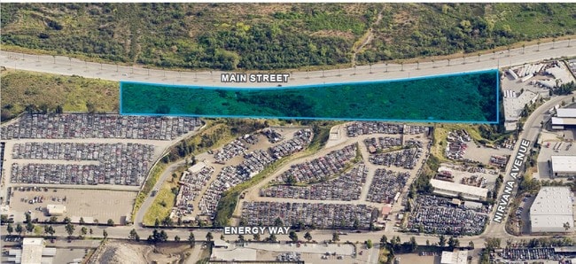
Main St, Chula Vista, CA 91911

Property Detail
Main St
644-050-14
PAR 1 TR PM21587
Industrialacreage
SAN DIEGO
IP
California
B and X Area of moderate flood hazard, usually the area between the limits of the 100-year and 500-year floods.
9.72 AC
2024
Chula Vista
2025
San Diego
013203
San Diego-Chula Vista-Carlsbad, CA
NEARBY LISTINGS FOR SALE OR LEASE
DEMOGRAPHICS near Main St
1 mile
3 mile
5 mile
2025 Total Population
6,379
129,104
330,822
2030 Population
6,591
129,552
330,759
Pop Growth 2025-2030
+ 3.32%
+ 0.35%
(0.02%)
Average Age
35
38
38
2025 Total Households
1,672
35,828
95,339
HH Growth 2025-2030
+ 3.23%
+ 0.20%
(0.17%)
Median Household Inc
$147,218
$118,757
$104,229
Avg Household Size
3.60
3.40
3.30
2025 Avg HH Vehicles
3.00
3.00
2.00
Median Home Value
$778,655
$738,031
$731,644
Median Year Built
2008
1992
1984
Nearby Places
Map Layers
Map Styles
 Street
 Aerial
Layers
 Traffic
 Biking
Places
Listings with unknown addresses are not visible on the map
- Restaurants
- Banks
- Shops
- Fitness
- Groceries
PUBLIC TRANSPORTATION
AIRPORT
San Diego International
Drive
Walk
Distance
San Diego International
25 min
18.0 mi
Freight Ports
Port of San Diego
Drive
Walk
Distance
Port of San Diego
21 min
13.7 mi
SALE & LEASE HISTORY
LISTING DATE
SALE/LEASE

Oct 25, 2018
For Sale
Jun 26, 2017
For Lease
Jun 18, 2019
For Sale
Aug 04, 2017
For Lease
Nearby Properties
Address
Land Use
TOTAL SIZE
Lot Size
Zoning
Address
Land Use
TOTAL SIZE
Lot Size
Zoning
16.49 AC
COP
Address
Land Use
TOTAL SIZE
Lot Size
Zoning
9.93 AC
PC15RM2
Address
Land Use
TOTAL SIZE
Lot Size
Zoning
8.31 AC
R3
Address
Land Use
TOTAL SIZE
Lot Size
Zoning
6.17 AC
PC16D6
Address
Land Use
TOTAL SIZE
Lot Size
Zoning
119 AC
I-7
Address
Land Use
TOTAL SIZE
Lot Size
Zoning
14.59 AC
PC9RC
Address
Land Use
TOTAL SIZE
Lot Size
Zoning
Address
Land Use
TOTAL SIZE
Lot Size
Zoning
212.15 AC
PC
Address
Land Use
TOTAL SIZE
Lot Size
Zoning
8.89 AC
PC15RM2
Address
Land Use
TOTAL SIZE
Lot Size
Zoning
10.79 AC
RM-3-7
Address
Land Use
TOTAL SIZE
Lot Size
Zoning
183,595 SF
27.99 AC
CC-1-3
Address
Land Use
TOTAL SIZE
Lot Size
Zoning
9,999 SF
7.04 AC
R-3
Address
Land Use
TOTAL SIZE
Lot Size
Zoning
10.17 AC
RM-3-7
Address
Land Use
TOTAL SIZE
Lot Size
Zoning
14.99 AC
RM-2-5
Address
Land Use
TOTAL SIZE
Lot Size
Zoning
9,999 SF
18.26 AC
PC10RM2
Address
Land Use
TOTAL SIZE
Lot Size
Zoning
37.96 AC
PC11SF3
Address
Land Use
TOTAL SIZE
Lot Size
Zoning
180.18 AC
PC
Address
Land Use
TOTAL SIZE
Lot Size
Zoning
8.56 AC
PC10RM2
Address
Land Use
TOTAL SIZE
Lot Size
Zoning
67,372 SF
4.67 AC
PC10C/RM2/
Address
Land Use
TOTAL SIZE
Lot Size
Zoning
13.24 AC
RM-2-4
Address
Land Use
TOTAL SIZE
Lot Size
Zoning
12.84 AC
RM-2-4
Address
Land Use
TOTAL SIZE
Lot Size
Zoning
5.49 AC
PC
Address
Land Use
TOTAL SIZE
Lot Size
Zoning
5.18 AC
IP-3-1
Address
Land Use
TOTAL SIZE
Lot Size
Zoning
7.67 AC
R-4
Address
Land Use
TOTAL SIZE
Lot Size
Zoning
5.85 AC
PC15RM2
Address
Land Use
TOTAL SIZE
Lot Size
Zoning
8.79 AC
R3
Address
Land Use
TOTAL SIZE
Lot Size
Zoning
7.60 AC
PC10RM2
Address
Land Use
TOTAL SIZE
Lot Size
Zoning
6.94 AC
PC10RM2
Address
Land Use
TOTAL SIZE
Lot Size
Zoning
1,273 SF
4.50 AC
RM-2-5
Address
Land Use
TOTAL SIZE
Lot Size
Zoning
10.34 AC
PC15RM2
The World's #1 Commercial Real Estate Marketplace
Connect with us
© 2026 CoStar Group
The information above has been obtained from sources believed reliable. While we do not doubt its accuracy we have not verified it and make no guarantee, warranty or representation about it. It is your responsibility to independently confirm its accuracy and completeness. Any projections, opinions, assumptions, or estimates used are for example only and do not represent the current or future performance of the property. The value of this transaction to you depends on tax and other factors which should be evaluated by your tax, financial, and legal advisors. You and your advisors should conduct a careful, independent investigation of the property to determine to your satisfaction the suitability of the property for your needs.