Property Record
Main St, Crystal Lake, IL 60014
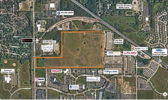
This Property Is For Sale
Property Detail
Main St
Chicago-Naperville-Elgin, IL-IN
RESUBDIVISION LOT9 CRYSTAL LK BUS CTR UN1 & PART SW4 SEC04 TWP43N RNG08E 3P
19-04-176-003
MCHENRY
Farms
Illinois
B and X Area of moderate flood hazard, usually the area between the limits of the 100-year and 500-year floods.
1
2024
42.58 AC
2024
Far Northwest
871301
Chicago
NEARBY LISTINGS FOR SALE OR LEASE
DEMOGRAPHICS near Main St
1 mile
3 mile
5 mile
2025 Total Population
4,774
43,605
115,835
2030 Population
4,867
44,177
117,073
Pop Growth 2025-2030
+ 1.95%
+ 1.31%
+ 1.07%
Average Age
41
41
41
2025 Total Households
1,832
16,295
41,962
HH Growth 2025-2030
+ 2.02%
+ 1.39%
+ 1.16%
Median Household Inc
$98,903
$99,069
$109,253
Avg Household Size
2.50
2.60
2.70
2025 Avg HH Vehicles
2.00
2.00
2.00
Median Home Value
$332,655
$316,916
$325,288
Median Year Built
1981
1980
1988
Nearby Places
Map Layers
Map Styles
 Street
 Aerial
Layers
 Traffic
 Biking
Places
Listings with unknown addresses are not visible on the map
- Restaurants
- Banks
- Shops
- Fitness
- Groceries
PUBLIC TRANSPORTATION
COMMUTER RAIL
Pingree Road Station (Union Pacific Northwest Line - Northeast Illinois Regional Commuter Railroad (Metra))
Drive
Walk
Distance
Pingree Road Station (Union Pacific Northwest Line - Northeast Illinois Regional Commuter Railroad (Metra))
3 min
10 min
0.5 mi
Crystal Lake Station (Union Pacific Northwest Line - Northeast Illinois Regional Commuter Railroad (Metra))
Drive
Walk
Distance
Crystal Lake Station (Union Pacific Northwest Line - Northeast Illinois Regional Commuter Railroad (Metra))
6 min
1.9 mi
AIRPORT
Chicago O'Hare International
Drive
Walk
Distance
Chicago O'Hare International
54 min
34.2 mi
Freight Ports
Port Milwaukee
Drive
Walk
Distance
Port Milwaukee
103 min
74.9 mi
Nearby Properties
Address
Land Use
TOTAL SIZE
Lot Size
Zoning
Address
Land Use
TOTAL SIZE
Lot Size
Zoning
Address
Land Use
TOTAL SIZE
Lot Size
Zoning
28.48 AC
Address
Land Use
TOTAL SIZE
Lot Size
Zoning
449,650 SF
25 AC
Address
Land Use
TOTAL SIZE
Lot Size
Zoning
15.94 AC
Address
Land Use
TOTAL SIZE
Lot Size
Zoning
147,496 SF
11.81 AC
Address
Land Use
TOTAL SIZE
Lot Size
Zoning
Address
Land Use
TOTAL SIZE
Lot Size
Zoning
Address
Land Use
TOTAL SIZE
Lot Size
Zoning
64,269 SF
5.08 AC
Address
Land Use
TOTAL SIZE
Lot Size
Zoning
20.81 AC
Address
Land Use
TOTAL SIZE
Lot Size
Zoning
187,594 SF
6.36 AC
Address
Land Use
TOTAL SIZE
Lot Size
Zoning
Address
Land Use
TOTAL SIZE
Lot Size
Zoning
173,572 SF
17.03 AC
Address
Land Use
TOTAL SIZE
Lot Size
Zoning
71,703 SF
0.50 AC
Address
Land Use
TOTAL SIZE
Lot Size
Zoning
362,936 SF
6.08 AC
Address
Land Use
TOTAL SIZE
Lot Size
Zoning
125,187 SF
10.59 AC
Address
Land Use
TOTAL SIZE
Lot Size
Zoning
86,400 SF
5.87 AC
Address
Land Use
TOTAL SIZE
Lot Size
Zoning
66,594 SF
5.22 AC
Address
Land Use
TOTAL SIZE
Lot Size
Zoning
47,164 SF
0.70 AC
Address
Land Use
TOTAL SIZE
Lot Size
Zoning
51,909 SF
0.50 AC
Address
Land Use
TOTAL SIZE
Lot Size
Zoning
34,448 SF
2 AC
Address
Land Use
TOTAL SIZE
Lot Size
Zoning
Address
Land Use
TOTAL SIZE
Lot Size
Zoning
127,059 SF
16.84 AC
Address
Land Use
TOTAL SIZE
Lot Size
Zoning
122,668 SF
9.73 AC
Address
Land Use
TOTAL SIZE
Lot Size
Zoning
161,610 SF
15.03 AC
Address
Land Use
TOTAL SIZE
Lot Size
Zoning
124,301 SF
8.80 AC
Address
Land Use
TOTAL SIZE
Lot Size
Zoning
10.48 AC
Address
Land Use
TOTAL SIZE
Lot Size
Zoning
30.77 AC
Address
Land Use
TOTAL SIZE
Lot Size
Zoning
141,363 SF
9 AC
Address
Land Use
TOTAL SIZE
Lot Size
Zoning
The World's #1 Commercial Real Estate Marketplace
Connect with us
© 2026 CoStar Group
The information above has been obtained from sources believed reliable. While we do not doubt its accuracy we have not verified it and make no guarantee, warranty or representation about it. It is your responsibility to independently confirm its accuracy and completeness. Any projections, opinions, assumptions, or estimates used are for example only and do not represent the current or future performance of the property. The value of this transaction to you depends on tax and other factors which should be evaluated by your tax, financial, and legal advisors. You and your advisors should conduct a careful, independent investigation of the property to determine to your satisfaction the suitability of the property for your needs.