Property Record
Main St, Fenton, MI 48430

Property Detail
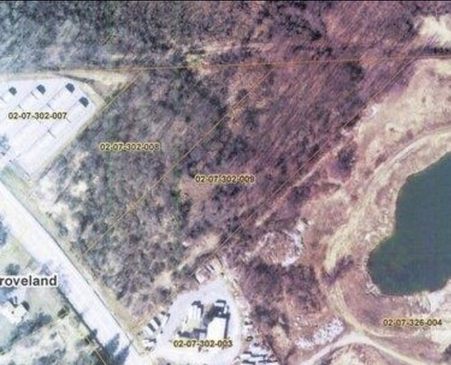
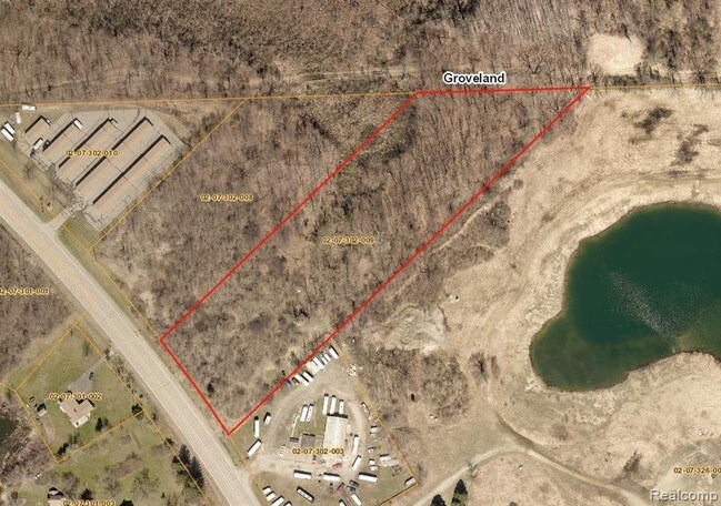
Main St
53-36-200-002
ALL THAT PART OF E 1/2 OF NE 1/4 LYING N OF D G H & M R R R/W EXCEPT N 260 FT OF W 300 FT SEC 36 T5N R6E (80)
Residentialacreage
GENESEE
LMR
Michigan
B and X Area of moderate flood hazard, usually the area between the limits of the 100-year and 500-year floods.
43 AC
2024
Flint
2025
Detroit
013206
Flint, MI
NEARBY LISTINGS FOR SALE OR LEASE
DEMOGRAPHICS near Main St
1 mile
3 mile
5 mile
2025 Total Population
4,134
22,088
47,584
2030 Population
4,109
22,048
47,717
Pop Growth 2025-2030
(0.60%)
(0.18%)
+ 0.28%
Average Age
41
41
42
2025 Total Households
1,707
9,161
19,141
HH Growth 2025-2030
(0.59%)
(0.29%)
+ 0.24%
Median Household Inc
$110,687
$93,292
$94,837
Avg Household Size
2.30
2.40
2.40
2025 Avg HH Vehicles
2.00
2.00
2.00
Median Home Value
$270,697
$292,244
$296,257
Median Year Built
1983
1983
1985
Nearby Places
Map Layers
Map Styles
 Street
 Aerial
Transit
 Traffic
 Biking
Places
Listings with unknown addresses are not visible on the map
- Restaurants
- Banks
- Shops
- Fitness
- Groceries
PUBLIC TRANSPORTATION
AIRPORT
Bishop International
Drive
Walk
Distance
Bishop International
30 min
16.0 mi
Freight Ports
Port of Toledo
Drive
Walk
Distance
Port of Toledo
121 min
100.2 mi
SALE & LEASE HISTORY
LISTING DATE
SALE/LEASE

Sep 24, 2016
For Sale
Mar 13, 2018
For Sale
Nearby Properties
Address
Land Use
TOTAL SIZE
Lot Size
Zoning
Address
Land Use
TOTAL SIZE
Lot Size
Zoning
572,804 SF
39.61 AC
SEVERAL
Address
Land Use
TOTAL SIZE
Lot Size
Zoning
30,286 SF
3.29 AC
SEVERAL
Address
Land Use
TOTAL SIZE
Lot Size
Zoning
215,494 SF
25.02 AC
GBD
Address
Land Use
TOTAL SIZE
Lot Size
Zoning
70,522 SF
23.58 AC
SEVERAL
Address
Land Use
TOTAL SIZE
Lot Size
Zoning
167,681 SF
20.39 AC
HDR
Address
Land Use
TOTAL SIZE
Lot Size
Zoning
82,447 SF
8.96 AC
GBD
Address
Land Use
TOTAL SIZE
Lot Size
Zoning
148,951 SF
10.02 AC
HDR
Address
Land Use
TOTAL SIZE
Lot Size
Zoning
176,132 SF
27.71 AC
R-M
Address
Land Use
TOTAL SIZE
Lot Size
Zoning
114,408 SF
13.53 AC
GBD
Address
Land Use
TOTAL SIZE
Lot Size
Zoning
87,925 SF
13.49 AC
GBD
Address
Land Use
TOTAL SIZE
Lot Size
Zoning
87,847 SF
12.71 AC
GBD
Address
Land Use
TOTAL SIZE
Lot Size
Zoning
126,064 SF
10.80 AC
GBD
Address
Land Use
TOTAL SIZE
Lot Size
Zoning
13,220 SF
7.90 AC
GBD
Address
Land Use
TOTAL SIZE
Lot Size
Zoning
97,830 SF
12.16 AC
GBD
Address
Land Use
TOTAL SIZE
Lot Size
Zoning
14,472 SF
1.97 AC
R-3
Address
Land Use
TOTAL SIZE
Lot Size
Zoning
145,076 SF
11.95 AC
HDR
Address
Land Use
TOTAL SIZE
Lot Size
Zoning
112,330 SF
11.82 AC
IND
Address
Land Use
TOTAL SIZE
Lot Size
Zoning
89,158 SF
7.87 AC
C-3
Address
Land Use
TOTAL SIZE
Lot Size
Zoning
46,732 SF
10.50 AC
SEVERAL
Address
Land Use
TOTAL SIZE
Lot Size
Zoning
41,427 SF
0.41 AC
CBD
Address
Land Use
TOTAL SIZE
Lot Size
Zoning
72,624 SF
8.18 AC
MHR
Address
Land Use
TOTAL SIZE
Lot Size
Zoning
44,343 SF
3.94 AC
NO DATA TO
Address
Land Use
TOTAL SIZE
Lot Size
Zoning
48,096 SF
6.39 AC
GBD
Address
Land Use
TOTAL SIZE
Lot Size
Zoning
30,000 SF
0.66 AC
HDR
Address
Land Use
TOTAL SIZE
Lot Size
Zoning
26,719 SF
4.07 AC
GBD
Address
Land Use
TOTAL SIZE
Lot Size
Zoning
103,896 SF
7.30 AC
IND
Address
Land Use
TOTAL SIZE
Lot Size
Zoning
73,243 SF
7.55 AC
NO DATA TO
Address
Land Use
TOTAL SIZE
Lot Size
Zoning
94,597 SF
9.10 AC
NO DATA TO
Address
Land Use
TOTAL SIZE
Lot Size
Zoning
92,600 SF
13.34 AC
Address
Land Use
TOTAL SIZE
Lot Size
Zoning
47,372 SF
7.12 AC
GBD
The World's #1 Commercial Real Estate Marketplace
Connect with us
© 2026 CoStar Group
The information above has been obtained from sources believed reliable. While we do not doubt its accuracy we have not verified it and make no guarantee, warranty or representation about it. It is your responsibility to independently confirm its accuracy and completeness. Any projections, opinions, assumptions, or estimates used are for example only and do not represent the current or future performance of the property. The value of this transaction to you depends on tax and other factors which should be evaluated by your tax, financial, and legal advisors. You and your advisors should conduct a careful, independent investigation of the property to determine to your satisfaction the suitability of the property for your needs.