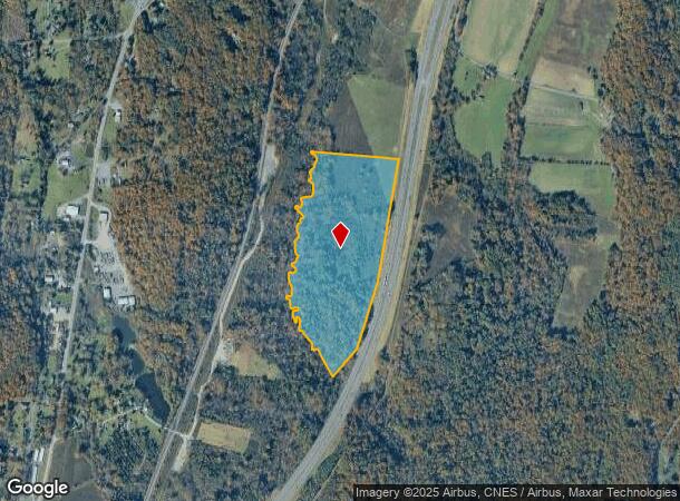
Property Record
Main St, Hannacroix, NY 12087
NEARBY LISTINGS FOR SALE OR LEASE
Property Detail
Main St
194200-017-003-0002-005-000-0000
Greene
Residentialacreage
New York
A
5.000
36039C0120F
40.48 AC
2025
Greene County
2024
Albany/Schenectady/Troy
080100
DEMOGRAPHICS near Main St
1 mile
3 mile
5 mile
2024 Total Population
288
2,405
12,061
2029 Population
284
2,368
12,012
Pop Growth 2024-2029
(1.39%)
(1.54%)
(0.41%)
Average Age
45
45
43
2024 Total Households
121
1,012
5,199
HH Growth 2024-2029
(1.65%)
(1.78%)
(0.48%)
Median Household Inc
$86,250
$82,674
$70,165
Avg Household Size
2.40
2.30
2.30
2024 Avg HH Vehicles
3.00
3.00
2.00
Median Home Value
$220,513
$223,913
$195,859
Median Year Built
1949
1951
1964
Nearby Places
Map Layers
Map Styles
 Street
 Aerial
Transit
 Traffic
 Biking
Places
Listings with unknown addresses are not visible on the map
- Restaurants
- Banks
- Shops
- Fitness
- Groceries
PUBLIC TRANSPORTATION
AIRPORT
Albany International
Drive
Walk
Distance
Albany International
46 min
33.6 mi
Freight Ports
Albany, NY Port
Drive
Walk
Distance
Albany, NY Port
28 min
20.4 mi
Nearby Properties
Address
Land Use
TOTAL SIZE
Lot Size
Zoning
Address
Land Use
TOTAL SIZE
Lot Size
Zoning
218,036 SF
19.60 AC
07 - MIXED
Address
Land Use
TOTAL SIZE
Lot Size
Zoning
230,900 SF
16.06 AC
05 - COMME
Address
Land Use
TOTAL SIZE
Lot Size
Zoning
164.73 AC
07 - MIXED
Address
Land Use
TOTAL SIZE
Lot Size
Zoning
143.63 AC
Address
Land Use
TOTAL SIZE
Lot Size
Zoning
4,342 SF
7.80 AC
07 - MIXED
Address
Land Use
TOTAL SIZE
Lot Size
Zoning
36,513 SF
2.24 AC
01 - NOT Z
Address
Land Use
TOTAL SIZE
Lot Size
Zoning
86,144 SF
24.70 AC
01 - NOT Z
Address
Land Use
TOTAL SIZE
Lot Size
Zoning
6,131 SF
3.50 AC
07 - MIXED
Address
Land Use
TOTAL SIZE
Lot Size
Zoning
5,564 SF
106.50 AC
07 - MIXED
Address
Land Use
TOTAL SIZE
Lot Size
Zoning
1,200 SF
50.48 AC
07 - MIXED
Address
Land Use
TOTAL SIZE
Lot Size
Zoning
5,308 SF
73.33 AC
07 - MIXED
Address
Land Use
TOTAL SIZE
Lot Size
Zoning
4,539 SF
2.63 AC
07 - MIXED
Address
Land Use
TOTAL SIZE
Lot Size
Zoning
30,720 SF
8.25 AC
01 - NOT Z
Address
Land Use
TOTAL SIZE
Lot Size
Zoning
3,910 SF
13 AC
07 - MIXED
Address
Land Use
TOTAL SIZE
Lot Size
Zoning
1,517 SF
240 AC
07 - MIXED
Address
Land Use
TOTAL SIZE
Lot Size
Zoning
3,135 SF
48.80 AC
07 - MIXED
Address
Land Use
TOTAL SIZE
Lot Size
Zoning
2,457 SF
123.07 AC
07 - MIXED
Address
Land Use
TOTAL SIZE
Lot Size
Zoning
3,677 SF
84.27 AC
07 - MIXED
Address
Land Use
TOTAL SIZE
Lot Size
Zoning
6,400 SF
11.73 AC
02 - SINGL
Address
Land Use
TOTAL SIZE
Lot Size
Zoning
6,300 SF
34.18 AC
01 - NOT Z
Address
Land Use
TOTAL SIZE
Lot Size
Zoning
3,900 SF
1.32 AC
07 - MIXED
Address
Land Use
TOTAL SIZE
Lot Size
Zoning
1,945 SF
14.52 AC
01 - NOT Z
Address
Land Use
TOTAL SIZE
Lot Size
Zoning
2,896 SF
104 AC
02 - SINGL
Address
Land Use
TOTAL SIZE
Lot Size
Zoning
0.56 AC
05 - COMME
Address
Land Use
TOTAL SIZE
Lot Size
Zoning
11,000 SF
13.20 AC
01 - NOT Z
Address
Land Use
TOTAL SIZE
Lot Size
Zoning
26.42 AC
03 - MULTI
Address
Land Use
TOTAL SIZE
Lot Size
Zoning
3,138 SF
0.80 AC
07 - MIXED
Address
Land Use
TOTAL SIZE
Lot Size
Zoning
7,724 SF
1.54 AC
02 - SINGL
Address
Land Use
TOTAL SIZE
Lot Size
Zoning
6,000 SF
3.30 AC
Address
Land Use
TOTAL SIZE
Lot Size
Zoning
1,600 SF
0.24 AC
07 - MIXED
The World's #1 Commercial Real Estate Marketplace
Connect with us
© 2026 CoStar Group
The information above has been obtained from sources believed reliable. While we do not doubt its accuracy we have not verified it and make no guarantee, warranty or representation about it. It is your responsibility to independently confirm its accuracy and completeness. Any projections, opinions, assumptions, or estimates used are for example only and do not represent the current or future performance of the property. The value of this transaction to you depends on tax and other factors which should be evaluated by your tax, financial, and legal advisors. You and your advisors should conduct a careful, independent investigation of the property to determine to your satisfaction the suitability of the property for your needs.