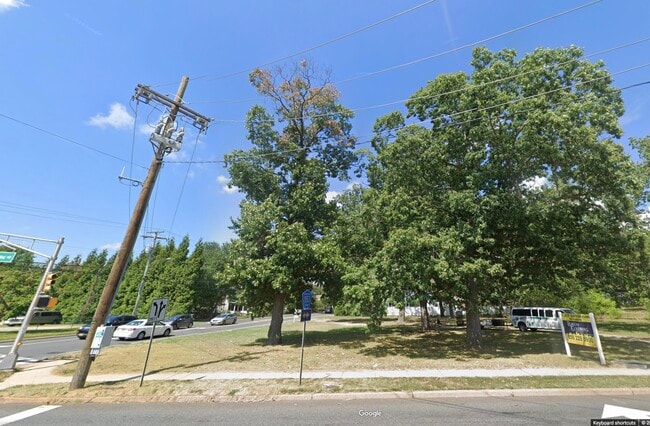
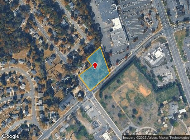
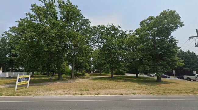
Property Record
N Main & Heston Rd, Glassboro, NJ 08028
Current Lease Availabilities
NEARBY LISTINGS FOR SALE OR LEASE
Property Detail
N Main & Heston Rd
06-00402-0000-00015
Gloucester
Vacantlandnec
New Jersey
X
15
34015C0201E
1.43 AC
2024
Gloucester County
2025
Philadelphia
501402
Philadelphia-Camden-Wilmington, PA-NJ-DE-MD
DEMOGRAPHICS near N Main & Heston Rd
1 Mile
3 Mile
5 Mile
2024 Total Population
15,766
55,149
107,063
2029 Population
16,296
57,176
110,740
Pop Growth 2024-2029
+ 3.36%
+ 3.68%
+ 3.43%
Average Age
33
39
40
2024 Total Households
4,290
18,826
37,304
HH Growth 2024-2029
+ 4.43%
+ 4.03%
+ 3.65%
Median Household Inc
$92,832
$91,039
$102,413
Avg Household Size
2.50
2.50
2.60
2024 Avg HH Vehicles
2.00
2.00
2.00
Median Home Value
$221,818
$260,580
$278,046
Median Year Built
1964
1980
1981
Nearby Places
- Restaurants
- Banks
- Shops
- Fitness
- Groceries
PUBLIC TRANSPORTATION
AIRPORT
Philadelphia International
DRIVE
WALK
Distance
Philadelphia International
38 min
23.4 mi
Freight Ports
Broadway Terminal - Pier 5
DRIVE
WALK
Distance
Broadway Terminal - Pier 5
22 min
14.9 mi
Nearby Properties
Address
Land Use
TOTAL SIZE
Lot Size
Zoning
Address
Land Use
TOTAL SIZE
Lot Size
Zoning
2,302 SF
61.32 AC
C55
Address
Land Use
TOTAL SIZE
Lot Size
Zoning
96.68 AC
P
Address
Land Use
TOTAL SIZE
Lot Size
Zoning
14.21 AC
INS
Address
Land Use
TOTAL SIZE
Lot Size
Zoning
3.34 AC
R3
Address
Land Use
TOTAL SIZE
Lot Size
Zoning
4.41 AC
Address
Land Use
TOTAL SIZE
Lot Size
Zoning
Address
Land Use
TOTAL SIZE
Lot Size
Zoning
Address
Land Use
TOTAL SIZE
Lot Size
Zoning
4.52 AC
P
Address
Land Use
TOTAL SIZE
Lot Size
Zoning
46.38 AC
P
Address
Land Use
TOTAL SIZE
Lot Size
Zoning
Address
Land Use
TOTAL SIZE
Lot Size
Zoning
69.68 AC
INS
Address
Land Use
TOTAL SIZE
Lot Size
Zoning
38.57 AC
INS
Address
Land Use
TOTAL SIZE
Lot Size
Zoning
25.71 AC
Address
Land Use
TOTAL SIZE
Lot Size
Zoning
Address
Land Use
TOTAL SIZE
Lot Size
Zoning
23.27 AC
C5
Address
Land Use
TOTAL SIZE
Lot Size
Zoning
26.35 AC
R4
Address
Land Use
TOTAL SIZE
Lot Size
Zoning
4.89 AC
RA
Address
Land Use
TOTAL SIZE
Lot Size
Zoning
28.68 AC
HC
Address
Land Use
TOTAL SIZE
Lot Size
Zoning
1.77 AC
Address
Land Use
TOTAL SIZE
Lot Size
Zoning
1.29 AC
Address
Land Use
TOTAL SIZE
Lot Size
Zoning
Address
Land Use
TOTAL SIZE
Lot Size
Zoning
Address
Land Use
TOTAL SIZE
Lot Size
Zoning
22.31 AC
C5
Address
Land Use
TOTAL SIZE
Lot Size
Zoning
14.57 AC
P
Address
Land Use
TOTAL SIZE
Lot Size
Zoning
2.68 AC
P
Address
Land Use
TOTAL SIZE
Lot Size
Zoning
1.52 AC
Address
Land Use
TOTAL SIZE
Lot Size
Zoning
1,316 SF
16.04 AC
PC
Address
Land Use
TOTAL SIZE
Lot Size
Zoning
7.04 AC
INS
Address
Land Use
TOTAL SIZE
Lot Size
Zoning
7.57 AC
P
Address
Land Use
TOTAL SIZE
Lot Size
Zoning
The World's #1 Commercial Real Estate Marketplace
Connect with us
© 2025 CoStar Group
The information above has been obtained from sources believed reliable. While we do not doubt its accuracy we have not verified it and make no guarantee, warranty or representation about it. It is your responsibility to independently confirm its accuracy and completeness. Any projections, opinions, assumptions, or estimates used are for example only and do not represent the current or future performance of the property. The value of this transaction to you depends on tax and other factors which should be evaluated by your tax, financial, and legal advisors. You and your advisors should conduct a careful, independent investigation of the property to determine to your satisfaction the suitability of the property for your needs.