Property Record
Main St, Lancaster, PA 17601

NEARBY LISTINGS FOR SALE OR LEASE
-
-
View all Lancaster listings for sale on LoopNet.com
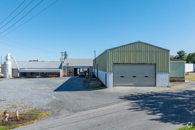
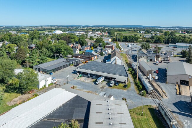
Property Detail
Main St
Lancaster, PA
Reading & Columbia Branch
290-51177-0-0000
3901 NOLT RD
Railroadfacility
Lancaster
X
Pennsylvania
42071C0331F
rd
2024
1.10 AC
2025
Lancaster County
011706
Philadelphia
DEMOGRAPHICS near Main St
1 Mile
3 Mile
5 Mile
2024 Total Population
4,553
19,300
82,322
2029 Population
4,610
19,439
82,984
Pop Growth 2024-2029
+ 1.25%
+ 0.72%
+ 0.80%
Average Age
42
43
42
2024 Total Households
1,719
7,139
32,264
HH Growth 2024-2029
+ 1.40%
+ 0.77%
+ 0.77%
Median Household Inc
$84,677
$97,108
$86,741
Avg Household Size
2.60
2.70
2.50
2024 Avg HH Vehicles
2.00
2.00
2.00
Median Home Value
$247,669
$284,964
$269,700
Median Year Built
1976
1981
1983
Nearby Places
Map Layers
Map Styles
 Street
 Aerial
- Restaurants
- Banks
- Shops
- Fitness
- Groceries
PUBLIC TRANSPORTATION
COMMUTER RAIL
Mount Joy Amtrak (Keystone Service - Amtrak)
DRIVE
WALK
Distance
Mount Joy Amtrak (Keystone Service - Amtrak)
9 min
5.1 mi
Lancaster (Keystone Service - Amtrak, Pennsylvanian - Amtrak)
DRIVE
WALK
Distance
Lancaster (Keystone Service - Amtrak, Pennsylvanian - Amtrak)
13 min
8.4 mi
AIRPORT
Harrisburg International
DRIVE
WALK
Distance
Harrisburg International
33 min
24.9 mi
Freight Ports
Port of Wilmington, RI
DRIVE
WALK
Distance
Port of Wilmington, RI
103 min
60.9 mi
Nearby Properties
Address
Land Use
TOTAL SIZE
Lot Size
Zoning
Address
Land Use
TOTAL SIZE
Lot Size
Zoning
887,130 SF
171.21 AC
Address
Land Use
TOTAL SIZE
Lot Size
Zoning
526,898 SF
26.10 AC
AH
Address
Land Use
TOTAL SIZE
Lot Size
Zoning
905,200 SF
68.60 AC
Address
Land Use
TOTAL SIZE
Lot Size
Zoning
686,568 SF
61.43 AC
Address
Land Use
TOTAL SIZE
Lot Size
Zoning
269,890 SF
57.10 AC
SR
Address
Land Use
TOTAL SIZE
Lot Size
Zoning
621,413 SF
79.20 AC
I-1
Address
Land Use
TOTAL SIZE
Lot Size
Zoning
718,859 SF
39.80 AC
I-2
Address
Land Use
TOTAL SIZE
Lot Size
Zoning
410,000 SF
30.35 AC
I
Address
Land Use
TOTAL SIZE
Lot Size
Zoning
237,347 SF
15.88 AC
I-1
Address
Land Use
TOTAL SIZE
Lot Size
Zoning
77,312 SF
24.79 AC
I-2
Address
Land Use
TOTAL SIZE
Lot Size
Zoning
4,002 SF
19.23 AC
CO
Address
Land Use
TOTAL SIZE
Lot Size
Zoning
55,728 SF
2.33 AC
Address
Land Use
TOTAL SIZE
Lot Size
Zoning
251,250 SF
18.26 AC
CO
Address
Land Use
TOTAL SIZE
Lot Size
Zoning
239,448 SF
28.74 AC
Address
Land Use
TOTAL SIZE
Lot Size
Zoning
252,800 SF
19.40 AC
CO
Address
Land Use
TOTAL SIZE
Lot Size
Zoning
104,882 SF
24.06 AC
HC
Address
Land Use
TOTAL SIZE
Lot Size
Zoning
59,142 SF
15.59 AC
HC
Address
Land Use
TOTAL SIZE
Lot Size
Zoning
92,929 SF
42.50 AC
AH
Address
Land Use
TOTAL SIZE
Lot Size
Zoning
82,286 SF
1.50 AC
I-2
Address
Land Use
TOTAL SIZE
Lot Size
Zoning
50,904 SF
Address
Land Use
TOTAL SIZE
Lot Size
Zoning
49,730 SF
14 AC
I
Address
Land Use
TOTAL SIZE
Lot Size
Zoning
106,078 SF
18 AC
I
Address
Land Use
TOTAL SIZE
Lot Size
Zoning
34,627 SF
5.24 AC
RURAL
Address
Land Use
TOTAL SIZE
Lot Size
Zoning
67,501 SF
Address
Land Use
TOTAL SIZE
Lot Size
Zoning
80,160 SF
9 AC
I-1
Address
Land Use
TOTAL SIZE
Lot Size
Zoning
48,447 SF
12.80 AC
SR
Address
Land Use
TOTAL SIZE
Lot Size
Zoning
89,008 SF
18.10 AC
SR
Address
Land Use
TOTAL SIZE
Lot Size
Zoning
54,836 SF
12.50 AC
C-2
Address
Land Use
TOTAL SIZE
Lot Size
Zoning
61,056 SF
5.56 AC
Address
Land Use
TOTAL SIZE
Lot Size
Zoning
37,986 SF
120.50 AC
The World's #1 Commercial Real Estate Marketplace
Connect with us
© 2025 CoStar Group
The information above has been obtained from sources believed reliable. While we do not doubt its accuracy we have not verified it and make no guarantee, warranty or representation about it. It is your responsibility to independently confirm its accuracy and completeness. Any projections, opinions, assumptions, or estimates used are for example only and do not represent the current or future performance of the property. The value of this transaction to you depends on tax and other factors which should be evaluated by your tax, financial, and legal advisors. You and your advisors should conduct a careful, independent investigation of the property to determine to your satisfaction the suitability of the property for your needs.