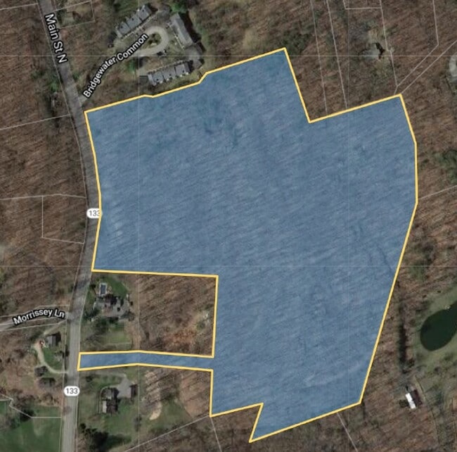
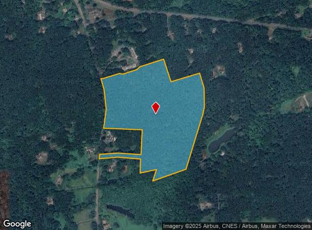
Property Record
Main St N, Bridgewater, CT 06752
NEARBY LISTINGS FOR SALE OR LEASE
Property Detail
Main St N
Torrington, CT
Litchfield
BRID-000040-000000-000008
Connecticut
Residentialacreage
24.13 AC
2024
New Milford/SW Litchfield
2025
Hartford
250100
DEMOGRAPHICS near Main St N
1 mile
3 mile
5 mile
2024 Total Population
637
8,161
29,379
2029 Population
632
8,162
29,459
Pop Growth 2024-2029
(0.78%)
+ 0.01%
+ 0.27%
Average Age
51
43
43
2024 Total Households
285
3,123
11,490
HH Growth 2024-2029
(0.70%)
(0.06%)
+ 0.27%
Median Household Inc
$137,946
$114,168
$99,769
Avg Household Size
2.20
2.60
2.50
2024 Avg HH Vehicles
3.00
2.00
2.00
Median Home Value
$630,734
$415,051
$392,126
Median Year Built
1971
1975
1975
Nearby Places
Map Layers
Map Styles
 Street
 Aerial
Transit
 Traffic
 Biking
Places
Listings with unknown addresses are not visible on the map
- Restaurants
- Banks
- Shops
- Fitness
- Groceries
SALE & LEASE HISTORY
LISTING DATE
SALE/LEASE

Feb 02, 2021
For Sale
Nearby Properties
Address
Land Use
TOTAL SIZE
Lot Size
Zoning
Address
Land Use
TOTAL SIZE
Lot Size
Zoning
42.62 AC
B1/RI
Address
Land Use
TOTAL SIZE
Lot Size
Zoning
227,659 SF
21.89 AC
I
Address
Land Use
TOTAL SIZE
Lot Size
Zoning
59.87 AC
RI
Address
Land Use
TOTAL SIZE
Lot Size
Zoning
5,658 SF
20.10 AC
RR3
Address
Land Use
TOTAL SIZE
Lot Size
Zoning
10.30 AC
B2
Address
Land Use
TOTAL SIZE
Lot Size
Zoning
6,984 SF
48.67 AC
RR3
Address
Land Use
TOTAL SIZE
Lot Size
Zoning
110,200 SF
4.96 AC
I-1 HO
Address
Land Use
TOTAL SIZE
Lot Size
Zoning
66.49 AC
C
Address
Land Use
TOTAL SIZE
Lot Size
Zoning
75,257 SF
16.70 AC
R40
Address
Land Use
TOTAL SIZE
Lot Size
Zoning
73,075 SF
8.79 AC
B1
Address
Land Use
TOTAL SIZE
Lot Size
Zoning
11,339 SF
15 AC
C
Address
Land Use
TOTAL SIZE
Lot Size
Zoning
8.07 AC
C
Address
Land Use
TOTAL SIZE
Lot Size
Zoning
8,008 SF
17.56 AC
C
Address
Land Use
TOTAL SIZE
Lot Size
Zoning
25,450 SF
9.16 AC
I
Address
Land Use
TOTAL SIZE
Lot Size
Zoning
6.09 AC
I
Address
Land Use
TOTAL SIZE
Lot Size
Zoning
73,510 SF
16.94 AC
RI
Address
Land Use
TOTAL SIZE
Lot Size
Zoning
26.84 AC
C
Address
Land Use
TOTAL SIZE
Lot Size
Zoning
2,811 SF
2 AC
MR
Address
Land Use
TOTAL SIZE
Lot Size
Zoning
20.20 AC
RR4
Address
Land Use
TOTAL SIZE
Lot Size
Zoning
7,409 SF
39.90 AC
RR4
Address
Land Use
TOTAL SIZE
Lot Size
Zoning
5.46 AC
B1
Address
Land Use
TOTAL SIZE
Lot Size
Zoning
6,273 SF
50.45 AC
A&C
Address
Land Use
TOTAL SIZE
Lot Size
Zoning
14.43 AC
C
Address
Land Use
TOTAL SIZE
Lot Size
Zoning
4.06 AC
I
Address
Land Use
TOTAL SIZE
Lot Size
Zoning
131,498 SF
7.66 AC
HRFZ
Address
Land Use
TOTAL SIZE
Lot Size
Zoning
8,517 SF
77.28 AC
RR3
Address
Land Use
TOTAL SIZE
Lot Size
Zoning
13.25 AC
B1
Address
Land Use
TOTAL SIZE
Lot Size
Zoning
1,952 SF
31.33 AC
RR3
Address
Land Use
TOTAL SIZE
Lot Size
Zoning
9,198 SF
15.81 AC
C
Address
Land Use
TOTAL SIZE
Lot Size
Zoning
5.68 AC
RI
The World's #1 Commercial Real Estate Marketplace
Connect with us
© 2026 CoStar Group
The information above has been obtained from sources believed reliable. While we do not doubt its accuracy we have not verified it and make no guarantee, warranty or representation about it. It is your responsibility to independently confirm its accuracy and completeness. Any projections, opinions, assumptions, or estimates used are for example only and do not represent the current or future performance of the property. The value of this transaction to you depends on tax and other factors which should be evaluated by your tax, financial, and legal advisors. You and your advisors should conduct a careful, independent investigation of the property to determine to your satisfaction the suitability of the property for your needs.