No Photo
Property Record
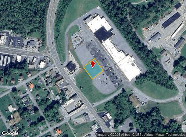
N Main St, Pearisburg, VA 24134
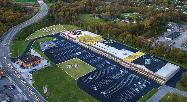
This Property Is For Sale
Current Lease Availabilities
NEARBY LISTINGS FOR SALE OR LEASE
Property Detail
N Main St
40A-10-C-19A
TRACT #2 PEARISBURG MARKETPLACE LLC
Commercialacreage
Giles
X
Virginia
51071C0205C
0.48 AC
2024
Blacksburg & Wytheville
2024
Other Market Areas
930400
Blacksburg-Christiansburg-Radford, VA
DEMOGRAPHICS near N Main St
1 Mile
3 Mile
5 Mile
2024 Total Population
2,102
4,467
8,170
2029 Population
2,064
4,378
8,008
Pop Growth 2024-2029
(1.81%)
(1.99%)
(1.98%)
Average Age
43
43
43
2024 Total Households
905
1,905
3,446
HH Growth 2024-2029
(1.77%)
(1.99%)
(1.94%)
Median Household Inc
$53,770
$59,651
$57,762
Avg Household Size
2.30
2.30
2.30
2024 Avg HH Vehicles
2.00
2.00
2.00
Median Home Value
$150,799
$154,552
$143,621
Median Year Built
1968
1968
1967
Nearby Places
- Restaurants
- Banks
- Shops
- Fitness
- Groceries
Nearby Properties
Address
Land Use
TOTAL SIZE
Lot Size
Zoning
Address
Land Use
TOTAL SIZE
Lot Size
Zoning
6.12 AC
T
Address
Land Use
TOTAL SIZE
Lot Size
Zoning
88,120 SF
23.50 AC
RRA1
Address
Land Use
TOTAL SIZE
Lot Size
Zoning
2,036 SF
25.44 AC
RRA1
Address
Land Use
TOTAL SIZE
Lot Size
Zoning
110,592 SF
10.15 AC
R-6
Address
Land Use
TOTAL SIZE
Lot Size
Zoning
4.56 AC
RRA1
Address
Land Use
TOTAL SIZE
Lot Size
Zoning
70,243 SF
14.05 AC
BR-3
Address
Land Use
TOTAL SIZE
Lot Size
Zoning
112,766 SF
19.44 AC
T
Address
Land Use
TOTAL SIZE
Lot Size
Zoning
12,300 SF
6.53 AC
RRA1
Address
Land Use
TOTAL SIZE
Lot Size
Zoning
4,648 SF
1.45 AC
BB-1
Address
Land Use
TOTAL SIZE
Lot Size
Zoning
60,860 SF
11.50 AC
M-1
Address
Land Use
TOTAL SIZE
Lot Size
Zoning
24,740 SF
2.77 AC
R-6
Address
Land Use
TOTAL SIZE
Lot Size
Zoning
25,009 SF
4.94 AC
BR-2
Address
Land Use
TOTAL SIZE
Lot Size
Zoning
10,296 SF
1.53 AC
BR-3
Address
Land Use
TOTAL SIZE
Lot Size
Zoning
73,204 SF
6.89 AC
M-1
Address
Land Use
TOTAL SIZE
Lot Size
Zoning
4,104 SF
4.91 AC
BR-2
Address
Land Use
TOTAL SIZE
Lot Size
Zoning
658.40 AC
A-1
Address
Land Use
TOTAL SIZE
Lot Size
Zoning
2,592 SF
5.64 AC
BR-2
Address
Land Use
TOTAL SIZE
Lot Size
Zoning
10,373 SF
4.30 AC
I-1
Address
Land Use
TOTAL SIZE
Lot Size
Zoning
26,335 SF
2.82 AC
BB-2
Address
Land Use
TOTAL SIZE
Lot Size
Zoning
4,513 SF
1.23 AC
T
Address
Land Use
TOTAL SIZE
Lot Size
Zoning
11,472 SF
0.10 AC
BB-1
Address
Land Use
TOTAL SIZE
Lot Size
Zoning
33,241 SF
6.96 AC
BR-2
Address
Land Use
TOTAL SIZE
Lot Size
Zoning
0.23 AC
RRA1
Address
Land Use
TOTAL SIZE
Lot Size
Zoning
30,625 SF
15.90 AC
RRA1
Address
Land Use
TOTAL SIZE
Lot Size
Zoning
71,340 SF
6.01 AC
M-1
Address
Land Use
TOTAL SIZE
Lot Size
Zoning
6,148 SF
1.24 AC
T
Address
Land Use
TOTAL SIZE
Lot Size
Zoning
10,344 SF
0.81 AC
BB-2
Address
Land Use
TOTAL SIZE
Lot Size
Zoning
11 AC
M-1
Address
Land Use
TOTAL SIZE
Lot Size
Zoning
12,000 SF
2.34 AC
T
Address
Land Use
TOTAL SIZE
Lot Size
Zoning
3,495 SF
1.02 AC
R-6
The World's #1 Commercial Real Estate Marketplace
Connect with us
© 2025 CoStar Group
The information above has been obtained from sources believed reliable. While we do not doubt its accuracy we have not verified it and make no guarantee, warranty or representation about it. It is your responsibility to independently confirm its accuracy and completeness. Any projections, opinions, assumptions, or estimates used are for example only and do not represent the current or future performance of the property. The value of this transaction to you depends on tax and other factors which should be evaluated by your tax, financial, and legal advisors. You and your advisors should conduct a careful, independent investigation of the property to determine to your satisfaction the suitability of the property for your needs.