Property Record
Manson Pike, Murfreesboro, TN 37129


This Property Is For Sale
Property Detail
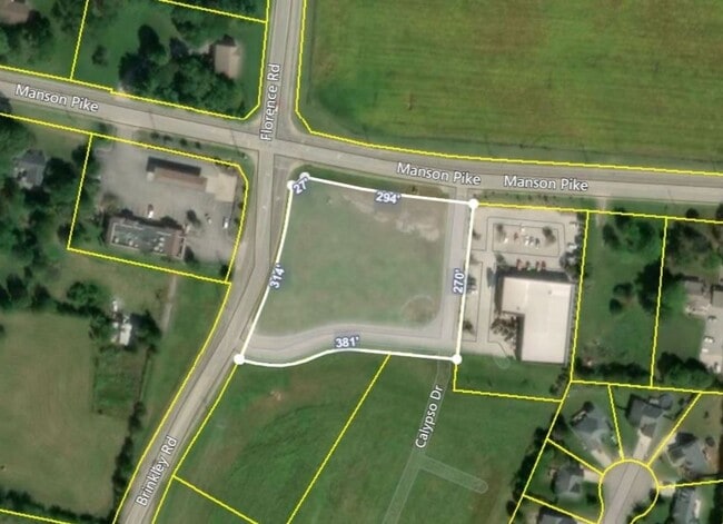
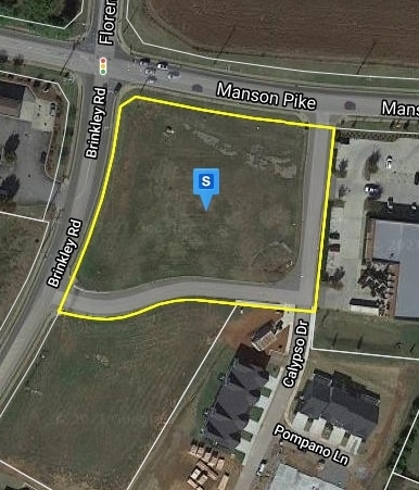
Manson Pike
Nashville-Davidson--Murfreesboro--Franklin, TN
RUTHERFORD
078-045.06-000
Tennessee
Commercialacreage
2
B and X Area of moderate flood hazard, usually the area between the limits of the 100-year and 500-year floods.
2.18 AC
2025
Rutherford County
2025
Nashville
041301
NEARBY LISTINGS FOR SALE OR LEASE
DEMOGRAPHICS near Manson Pike
1 mile
3 mile
5 mile
2025 Total Population
8,150
47,359
106,945
2030 Population
8,863
51,738
116,108
Pop Growth 2025-2030
+ 8.75%
+ 9.25%
+ 8.57%
Average Age
34
35
37
2025 Total Households
3,009
17,445
39,887
HH Growth 2025-2030
+ 8.54%
+ 9.30%
+ 8.60%
Median Household Inc
$100,649
$93,613
$93,804
Avg Household Size
2.70
2.70
2.60
2025 Avg HH Vehicles
2.00
2.00
2.00
Median Home Value
$457,178
$439,877
$430,157
Median Year Built
2010
2009
2004
Nearby Places
Map Layers
Map Styles
 Street
 Aerial
Layers
 Traffic
 Biking
Places
Listings with unknown addresses are not visible on the map
- Restaurants
- Banks
- Shops
- Fitness
- Groceries
PUBLIC TRANSPORTATION
AIRPORT
Nashville International
Drive
Walk
Distance
Nashville International
33 min
25.6 mi
Freight Ports
Port of Mobile
Drive
Walk
Distance
Port of Mobile
483 min
442.9 mi
Nearby Properties
Address
Land Use
TOTAL SIZE
Lot Size
Zoning
Address
Land Use
TOTAL SIZE
Lot Size
Zoning
812,152 SF
85.61 AC
Address
Land Use
TOTAL SIZE
Lot Size
Zoning
369,709 SF
76.83 AC
Address
Land Use
TOTAL SIZE
Lot Size
Zoning
104,174 SF
11.06 AC
Address
Land Use
TOTAL SIZE
Lot Size
Zoning
12,391 SF
20.36 AC
Address
Land Use
TOTAL SIZE
Lot Size
Zoning
167,712 SF
24.60 AC
Address
Land Use
TOTAL SIZE
Lot Size
Zoning
5,260 SF
21.91 AC
Address
Land Use
TOTAL SIZE
Lot Size
Zoning
4,454 SF
22.26 AC
Address
Land Use
TOTAL SIZE
Lot Size
Zoning
208,990 SF
51.06 AC
Address
Land Use
TOTAL SIZE
Lot Size
Zoning
3,114 SF
32.12 AC
Address
Land Use
TOTAL SIZE
Lot Size
Zoning
6,000 SF
23.52 AC
Address
Land Use
TOTAL SIZE
Lot Size
Zoning
1,990 SF
28.14 AC
Address
Land Use
TOTAL SIZE
Lot Size
Zoning
7,510 SF
22.83 AC
Address
Land Use
TOTAL SIZE
Lot Size
Zoning
1,792 SF
17.48 AC
Address
Land Use
TOTAL SIZE
Lot Size
Zoning
79,122 SF
15 AC
Address
Land Use
TOTAL SIZE
Lot Size
Zoning
6,154 SF
23.04 AC
Address
Land Use
TOTAL SIZE
Lot Size
Zoning
17,330 SF
10.20 AC
Address
Land Use
TOTAL SIZE
Lot Size
Zoning
5,094 SF
19.53 AC
RM16
Address
Land Use
TOTAL SIZE
Lot Size
Zoning
7,704 SF
17.15 AC
CF
Address
Land Use
TOTAL SIZE
Lot Size
Zoning
9,072 SF
18 AC
Address
Land Use
TOTAL SIZE
Lot Size
Zoning
13,818 SF
7.43 AC
Address
Land Use
TOTAL SIZE
Lot Size
Zoning
128,256 SF
17.63 AC
Address
Land Use
TOTAL SIZE
Lot Size
Zoning
5,308 SF
14.95 AC
Address
Land Use
TOTAL SIZE
Lot Size
Zoning
28,234 SF
5.49 AC
Address
Land Use
TOTAL SIZE
Lot Size
Zoning
2,284 SF
21.85 AC
RM16
Address
Land Use
TOTAL SIZE
Lot Size
Zoning
118,826 SF
31.14 AC
Address
Land Use
TOTAL SIZE
Lot Size
Zoning
4,839 SF
11.58 AC
Address
Land Use
TOTAL SIZE
Lot Size
Zoning
114,829 SF
26 AC
Address
Land Use
TOTAL SIZE
Lot Size
Zoning
5,712 SF
11.45 AC
Address
Land Use
TOTAL SIZE
Lot Size
Zoning
17,712 SF
3.43 AC
Address
Land Use
TOTAL SIZE
Lot Size
Zoning
62,624 SF
The World's #1 Commercial Real Estate Marketplace
Connect with us
© 2026 CoStar Group
The information above has been obtained from sources believed reliable. While we do not doubt its accuracy we have not verified it and make no guarantee, warranty or representation about it. It is your responsibility to independently confirm its accuracy and completeness. Any projections, opinions, assumptions, or estimates used are for example only and do not represent the current or future performance of the property. The value of this transaction to you depends on tax and other factors which should be evaluated by your tax, financial, and legal advisors. You and your advisors should conduct a careful, independent investigation of the property to determine to your satisfaction the suitability of the property for your needs.