Property Record
Mantonya Rd, 29 Palms, CA 92277

Property Detail
Mantonya Rd
Riverside-San Bernardino-Ontario, CA
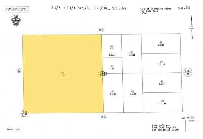
SW 1/4 NE 1/4 SEC 20 TP 1N R 8E
0609-061-01
SAN BERNARDINO
Vacantlandnec
California
B and X Area of moderate flood hazard, usually the area between the limits of the 100-year and 500-year floods.
40 AC
2025
Twentynine Palms
2025
Inland Empire (California)
010422
NEARBY LISTINGS FOR SALE OR LEASE
DEMOGRAPHICS near Mantonya Rd
1 mile
3 mile
5 mile
2025 Total Population
48
1,501
8,178
2030 Population
50
1,575
8,490
Pop Growth 2025-2030
+ 4.17%
+ 4.93%
+ 3.82%
Average Age
45
44
40
2025 Total Households
22
657
3,369
HH Growth 2025-2030
+ 4.55%
+ 4.87%
+ 3.86%
Median Household Inc
$67,500
$69,642
$68,370
Avg Household Size
2.10
2.30
2.40
2025 Avg HH Vehicles
2.00
2.00
2.00
Median Home Value
$233,333
$264,159
$277,291
Median Year Built
1974
1978
1980
Nearby Places
Map Layers
Map Styles
 Street
 Aerial
Layers
 Traffic
 Biking
Places
Listings with unknown addresses are not visible on the map
- Restaurants
- Banks
- Shops
- Fitness
- Groceries
PUBLIC TRANSPORTATION
AIRPORT
Palm Springs International
Drive
Walk
Distance
Palm Springs International
71 min
47.4 mi
Nearby Properties
Address
Land Use
TOTAL SIZE
Lot Size
Zoning
Address
Land Use
TOTAL SIZE
Lot Size
Zoning
23,514 SF
111 AC
Address
Land Use
TOTAL SIZE
Lot Size
Zoning
91.66 AC
Address
Land Use
TOTAL SIZE
Lot Size
Zoning
218.80 AC
RC
Address
Land Use
TOTAL SIZE
Lot Size
Zoning
2,565 SF
0.56 AC
Address
Land Use
TOTAL SIZE
Lot Size
Zoning
2,171 SF
20 AC
Address
Land Use
TOTAL SIZE
Lot Size
Zoning
2,200 SF
0.60 AC
Address
Land Use
TOTAL SIZE
Lot Size
Zoning
18.03 AC
Address
Land Use
TOTAL SIZE
Lot Size
Zoning
316.97 AC
Address
Land Use
TOTAL SIZE
Lot Size
Zoning
1,866 SF
17.88 AC
Address
Land Use
TOTAL SIZE
Lot Size
Zoning
Address
Land Use
TOTAL SIZE
Lot Size
Zoning
720 SF
40 AC
Address
Land Use
TOTAL SIZE
Lot Size
Zoning
10 AC
JTRL5
Address
Land Use
TOTAL SIZE
Lot Size
Zoning
1,880 SF
2.25 AC
Address
Land Use
TOTAL SIZE
Lot Size
Zoning
73.31 AC
Address
Land Use
TOTAL SIZE
Lot Size
Zoning
532 SF
20 AC
Address
Land Use
TOTAL SIZE
Lot Size
Zoning
151.53 AC
Address
Land Use
TOTAL SIZE
Lot Size
Zoning
5,902 SF
8.89 AC
Address
Land Use
TOTAL SIZE
Lot Size
Zoning
80 AC
RL
Address
Land Use
TOTAL SIZE
Lot Size
Zoning
128 AC
RL5
Address
Land Use
TOTAL SIZE
Lot Size
Zoning
Address
Land Use
TOTAL SIZE
Lot Size
Zoning
1,622 SF
0.27 AC
Address
Land Use
TOTAL SIZE
Lot Size
Zoning
8.66 AC
Address
Land Use
TOTAL SIZE
Lot Size
Zoning
Address
Land Use
TOTAL SIZE
Lot Size
Zoning
2,925 SF
1.16 AC
Address
Land Use
TOTAL SIZE
Lot Size
Zoning
4.79 AC
Address
Land Use
TOTAL SIZE
Lot Size
Zoning
19.55 AC
Address
Land Use
TOTAL SIZE
Lot Size
Zoning
Address
Land Use
TOTAL SIZE
Lot Size
Zoning
40 AC
JTRL5
The World's #1 Commercial Real Estate Marketplace
Connect with us
© 2026 CoStar Group
The information above has been obtained from sources believed reliable. While we do not doubt its accuracy we have not verified it and make no guarantee, warranty or representation about it. It is your responsibility to independently confirm its accuracy and completeness. Any projections, opinions, assumptions, or estimates used are for example only and do not represent the current or future performance of the property. The value of this transaction to you depends on tax and other factors which should be evaluated by your tax, financial, and legal advisors. You and your advisors should conduct a careful, independent investigation of the property to determine to your satisfaction the suitability of the property for your needs.