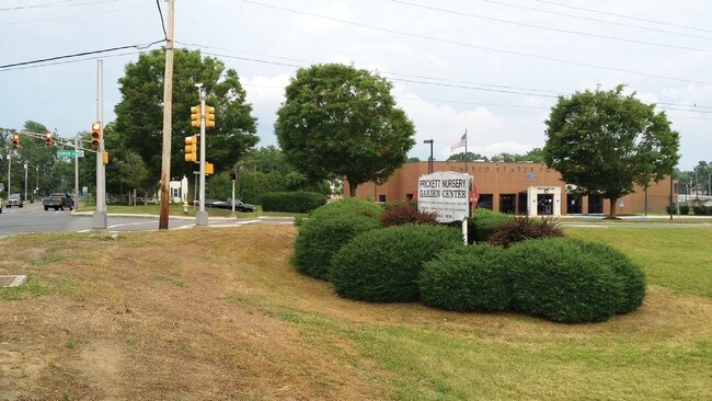
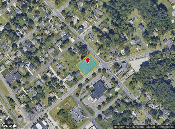
Property Record
Mantua Blvd, Mantua, NJ 08051

NEARBY LISTINGS FOR SALE OR LEASE
Property Detail
Mantua Blvd
10-00205-0000-00002
Gloucester
Vacantlandnec
New Jersey
X
2
34015C0094E
0.69 AC
2024
Gloucester County
2025
Philadelphia
500704
Philadelphia-Camden-Wilmington, PA-NJ-DE-MD
DEMOGRAPHICS near Mantua Blvd
1 Mile
3 Mile
5 Mile
2024 Total Population
4,258
44,595
146,137
2029 Population
4,383
46,099
150,926
Pop Growth 2024-2029
+ 2.94%
+ 3.37%
+ 3.28%
Average Age
42
42
40
2024 Total Households
1,542
16,944
52,988
HH Growth 2024-2029
+ 2.92%
+ 3.39%
+ 3.43%
Median Household Inc
$113,892
$104,669
$97,882
Avg Household Size
2.70
2.60
2.60
2024 Avg HH Vehicles
2.00
2.00
2.00
Median Home Value
$322,032
$277,160
$269,710
Median Year Built
1989
1980
1977
Nearby Places
Map Layers
Map Styles
 Street
 Aerial
- Restaurants
- Banks
- Shops
- Fitness
- Groceries
PUBLIC TRANSPORTATION
AIRPORT
Philadelphia International
DRIVE
WALK
Distance
Philadelphia International
35 min
21.1 mi
Freight Ports
Broadway Terminal - Pier 5
DRIVE
WALK
Distance
Broadway Terminal - Pier 5
20 min
12.6 mi
SALE & LEASE HISTORY
LISTING DATE
SALE/LEASE

Sep 28, 2016
For Sale
Sep 24, 2016
For Sale
Sep 11, 2017
For Sale
Nearby Properties
Address
Land Use
TOTAL SIZE
Lot Size
Zoning
Address
Land Use
TOTAL SIZE
Lot Size
Zoning
228.36 AC
INS
Address
Land Use
TOTAL SIZE
Lot Size
Zoning
32.64 AC
INS
Address
Land Use
TOTAL SIZE
Lot Size
Zoning
63.46 AC
INS
Address
Land Use
TOTAL SIZE
Lot Size
Zoning
4.89 AC
RA
Address
Land Use
TOTAL SIZE
Lot Size
Zoning
21.16 AC
INS
Address
Land Use
TOTAL SIZE
Lot Size
Zoning
15.98 AC
PC
Address
Land Use
TOTAL SIZE
Lot Size
Zoning
1,316 SF
16.04 AC
PC
Address
Land Use
TOTAL SIZE
Lot Size
Zoning
7.01 AC
R11
Address
Land Use
TOTAL SIZE
Lot Size
Zoning
8.89 AC
Address
Land Use
TOTAL SIZE
Lot Size
Zoning
14.11 AC
SC
Address
Land Use
TOTAL SIZE
Lot Size
Zoning
12.01 AC
RA
Address
Land Use
TOTAL SIZE
Lot Size
Zoning
14.14 AC
R11
Address
Land Use
TOTAL SIZE
Lot Size
Zoning
12.73 AC
Address
Land Use
TOTAL SIZE
Lot Size
Zoning
2.62 AC
Address
Land Use
TOTAL SIZE
Lot Size
Zoning
19.43 AC
PR1
Address
Land Use
TOTAL SIZE
Lot Size
Zoning
27.40 AC
LI
Address
Land Use
TOTAL SIZE
Lot Size
Zoning
Address
Land Use
TOTAL SIZE
Lot Size
Zoning
76.61 AC
PI
Address
Land Use
TOTAL SIZE
Lot Size
Zoning
11.51 AC
Address
Land Use
TOTAL SIZE
Lot Size
Zoning
14.43 AC
CC
Address
Land Use
TOTAL SIZE
Lot Size
Zoning
7.53 AC
RA
Address
Land Use
TOTAL SIZE
Lot Size
Zoning
Address
Land Use
TOTAL SIZE
Lot Size
Zoning
6.27 AC
INS
Address
Land Use
TOTAL SIZE
Lot Size
Zoning
4.52 AC
MUD
Address
Land Use
TOTAL SIZE
Lot Size
Zoning
10.15 AC
LI
Address
Land Use
TOTAL SIZE
Lot Size
Zoning
3.59 AC
CI
Address
Land Use
TOTAL SIZE
Lot Size
Zoning
6.80 AC
CI
Address
Land Use
TOTAL SIZE
Lot Size
Zoning
16.14 AC
PC
Address
Land Use
TOTAL SIZE
Lot Size
Zoning
25.47 AC
I
Address
Land Use
TOTAL SIZE
Lot Size
Zoning
3.79 AC
PRC
The World's #1 Commercial Real Estate Marketplace
Connect with us
© 2025 CoStar Group
The information above has been obtained from sources believed reliable. While we do not doubt its accuracy we have not verified it and make no guarantee, warranty or representation about it. It is your responsibility to independently confirm its accuracy and completeness. Any projections, opinions, assumptions, or estimates used are for example only and do not represent the current or future performance of the property. The value of this transaction to you depends on tax and other factors which should be evaluated by your tax, financial, and legal advisors. You and your advisors should conduct a careful, independent investigation of the property to determine to your satisfaction the suitability of the property for your needs.