Property Record
Maple Ave, Claverack, NY 12513
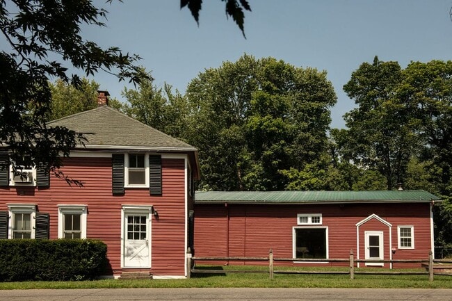

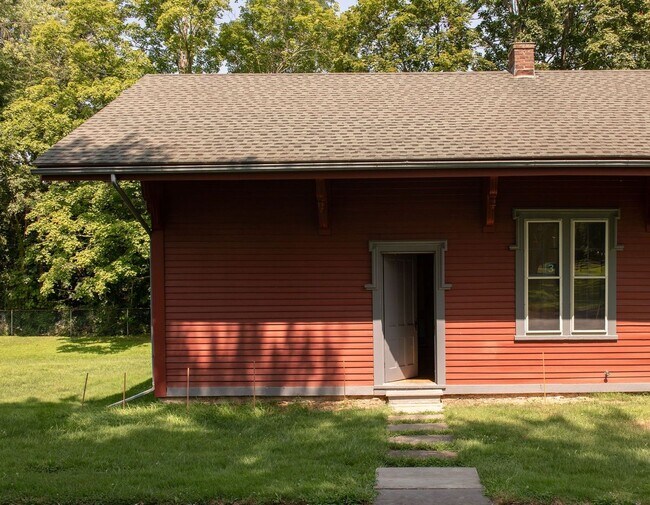
This Property Is For Sale
Property Detail
Maple Ave
102889-121-003-0001-036-000-0000
COLUMBIA
Warehouse
New York
07 - MIXED
36.000
2025
0.97 AC
2025
Columbia County
001000
Albany/Schenectady/Troy
1,352 SF
Hudson, NY
NEARBY LISTINGS FOR SALE OR LEASE
DEMOGRAPHICS near Maple Ave
1 mile
3 mile
5 mile
2025 Total Population
916
7,296
18,151
2030 Population
885
7,063
17,643
Pop Growth 2025-2030
(3.38%)
(3.19%)
(2.80%)
Average Age
48
46
45
2025 Total Households
402
3,278
8,111
HH Growth 2025-2030
(3.48%)
(3.29%)
(2.86%)
Median Household Inc
$94,583
$82,263
$71,135
Avg Household Size
2.10
2.10
2.10
2025 Avg HH Vehicles
2.00
2.00
2.00
Median Home Value
$306,250
$289,197
$305,665
Median Year Built
1977
1957
1959
Nearby Places
Map Layers
Map Styles
 Street
 Aerial
Layers
 Traffic
 Biking
Places
Listings with unknown addresses are not visible on the map
- Restaurants
- Banks
- Shops
- Fitness
- Groceries
PUBLIC TRANSPORTATION
COMMUTER RAIL
Drive
Walk
Distance
10 min
4.7 mi
Freight Ports
Albany, NY Port
Drive
Walk
Distance
Albany, NY Port
49 min
35.1 mi
Nearby Properties
Address
Land Use
TOTAL SIZE
Lot Size
Zoning
Address
Land Use
TOTAL SIZE
Lot Size
Zoning
177,400 SF
6.30 AC
R5
Address
Land Use
TOTAL SIZE
Lot Size
Zoning
88,326 SF
121.10 AC
R1
Address
Land Use
TOTAL SIZE
Lot Size
Zoning
204,349 SF
20.37 AC
402
Address
Land Use
TOTAL SIZE
Lot Size
Zoning
60,746 SF
7.75 AC
06 - INDUS
Address
Land Use
TOTAL SIZE
Lot Size
Zoning
132,945 SF
21.60 AC
R1
Address
Land Use
TOTAL SIZE
Lot Size
Zoning
72,014 SF
1.30 AC
R5
Address
Land Use
TOTAL SIZE
Lot Size
Zoning
Address
Land Use
TOTAL SIZE
Lot Size
Zoning
116,852 SF
20.08 AC
402
Address
Land Use
TOTAL SIZE
Lot Size
Zoning
1,226.97 AC
07
Address
Land Use
TOTAL SIZE
Lot Size
Zoning
6,164 SF
426.70 AC
07 - MIXED
Address
Land Use
TOTAL SIZE
Lot Size
Zoning
26,420 SF
5.51 AC
07 - MIXED
Address
Land Use
TOTAL SIZE
Lot Size
Zoning
150,204 SF
31.51 AC
07 - MIXED
Address
Land Use
TOTAL SIZE
Lot Size
Zoning
20,800 SF
21.23 AC
08 - GOVER
Address
Land Use
TOTAL SIZE
Lot Size
Zoning
Address
Land Use
TOTAL SIZE
Lot Size
Zoning
180,601 SF
19.22 AC
07 - MIXED
Address
Land Use
TOTAL SIZE
Lot Size
Zoning
34.82 AC
03 - MULTI
Address
Land Use
TOTAL SIZE
Lot Size
Zoning
57,869 SF
6.20 AC
402
Address
Land Use
TOTAL SIZE
Lot Size
Zoning
75,916 SF
7.40 AC
06 - INDUS
Address
Land Use
TOTAL SIZE
Lot Size
Zoning
2,856 SF
8.32 AC
401
Address
Land Use
TOTAL SIZE
Lot Size
Zoning
216 SF
220.20 AC
07 - MIXED
Address
Land Use
TOTAL SIZE
Lot Size
Zoning
16,000 SF
5.60 AC
401
Address
Land Use
TOTAL SIZE
Lot Size
Zoning
103,366 SF
1.30 AC
R5
Address
Land Use
TOTAL SIZE
Lot Size
Zoning
12,273 SF
159.66 AC
07 - MIXED
Address
Land Use
TOTAL SIZE
Lot Size
Zoning
1,500 SF
8.70 AC
08 - GOVER
Address
Land Use
TOTAL SIZE
Lot Size
Zoning
5,230 SF
29.70 AC
01 - NOT Z
Address
Land Use
TOTAL SIZE
Lot Size
Zoning
3,000 SF
90.03 AC
07 - MIXED
Address
Land Use
TOTAL SIZE
Lot Size
Zoning
94,278 SF
5.63 AC
401
Address
Land Use
TOTAL SIZE
Lot Size
Zoning
19,760 SF
3.74 AC
401
Address
Land Use
TOTAL SIZE
Lot Size
Zoning
27,591 SF
0.71 AC
R1
Address
Land Use
TOTAL SIZE
Lot Size
Zoning
57,472 SF
2.80 AC
GCT
The World's #1 Commercial Real Estate Marketplace
Connect with us
© 2026 CoStar Group
The information above has been obtained from sources believed reliable. While we do not doubt its accuracy we have not verified it and make no guarantee, warranty or representation about it. It is your responsibility to independently confirm its accuracy and completeness. Any projections, opinions, assumptions, or estimates used are for example only and do not represent the current or future performance of the property. The value of this transaction to you depends on tax and other factors which should be evaluated by your tax, financial, and legal advisors. You and your advisors should conduct a careful, independent investigation of the property to determine to your satisfaction the suitability of the property for your needs.