Property Record
Maple Ave, Irving, NY 75015
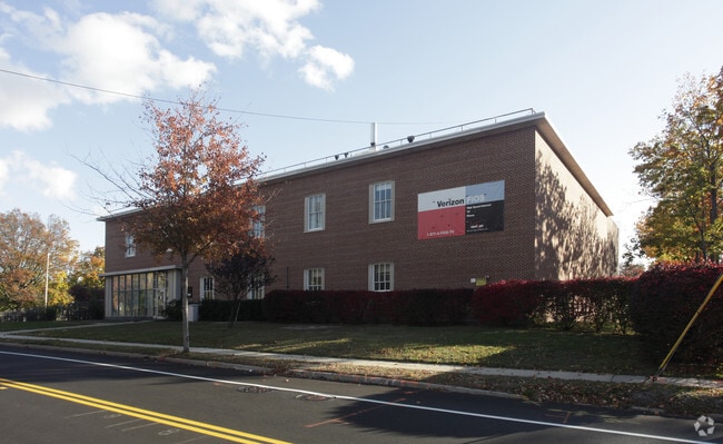

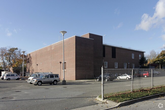
Property Detail
Maple Ave
Nassau County-Suffolk County, NY
3-101701.1 TC-70 RADAU NY TELEPHONE DICANIO MAPLE AVE
0800-104-00-02-00-004-000
SUFFOLK
Telephonefacility
New York
B and X Area of moderate flood hazard, usually the area between the limits of the 100-year and 500-year floods.
4
2024
2.27 AC
2025
Hauppauge
134909
Long Island (New York)
NEARBY LISTINGS FOR SALE OR LEASE
DEMOGRAPHICS near Maple Ave
1 mile
3 mile
5 mile
2025 Total Population
6,848
66,011
195,424
2030 Population
6,814
65,748
193,791
Pop Growth 2025-2030
(0.50%)
(0.40%)
(0.84%)
Average Age
42
43
42
2025 Total Households
2,305
22,294
62,565
HH Growth 2025-2030
(0.82%)
(0.74%)
(1.05%)
Median Household Inc
$149,026
$142,437
$132,071
Avg Household Size
2.90
2.80
3.00
2025 Avg HH Vehicles
2.00
2.00
2.00
Median Home Value
$723,857
$732,893
$666,984
Median Year Built
1964
1967
1967
Nearby Places
Map Layers
Map Styles
 Street
 Aerial
Layers
 Traffic
 Biking
Places
Listings with unknown addresses are not visible on the map
- Restaurants
- Banks
- Shops
- Fitness
- Groceries
PUBLIC TRANSPORTATION
TRANSIT/SUBWAY
Smithtown Station (Port Jefferson Branch - Long Island Rail Road)
Drive
Walk
Distance
Smithtown Station (Port Jefferson Branch - Long Island Rail Road)
1 min
7 min
0.3 mi
COMMUTER RAIL
Smithtown Station (Port Jefferson Branch - Long Island Rail Road)
Drive
Walk
Distance
Smithtown Station (Port Jefferson Branch - Long Island Rail Road)
2 min
7 min
0.4 mi
St James Station (Port Jefferson Branch - Long Island Rail Road)
Drive
Walk
Distance
St James Station (Port Jefferson Branch - Long Island Rail Road)
7 min
3.7 mi
AIRPORT
Long Island MacArthur
Drive
Walk
Distance
Long Island MacArthur
18 min
9.6 mi
Nearby Properties
Address
Land Use
TOTAL SIZE
Lot Size
Zoning
Address
Land Use
TOTAL SIZE
Lot Size
Zoning
301 SF
3.70 AC
Address
Land Use
TOTAL SIZE
Lot Size
Zoning
97.50 AC
AAA
Address
Land Use
TOTAL SIZE
Lot Size
Zoning
57.30 AC
AAA
Address
Land Use
TOTAL SIZE
Lot Size
Zoning
24.96 AC
Address
Land Use
TOTAL SIZE
Lot Size
Zoning
5.32 AC
BUS3
Address
Land Use
TOTAL SIZE
Lot Size
Zoning
24.70 AC
AAA
Address
Land Use
TOTAL SIZE
Lot Size
Zoning
13.06 AC
BUS3
Address
Land Use
TOTAL SIZE
Lot Size
Zoning
15 AC
AA
Address
Land Use
TOTAL SIZE
Lot Size
Zoning
8.02 AC
NULL
Address
Land Use
TOTAL SIZE
Lot Size
Zoning
10.50 AC
NULL
Address
Land Use
TOTAL SIZE
Lot Size
Zoning
12.80 AC
AAA
Address
Land Use
TOTAL SIZE
Lot Size
Zoning
8.35 AC
IND1
Address
Land Use
TOTAL SIZE
Lot Size
Zoning
9.90 AC
CA
Address
Land Use
TOTAL SIZE
Lot Size
Zoning
10.30 AC
CA
Address
Land Use
TOTAL SIZE
Lot Size
Zoning
6.60 AC
CA
Address
Land Use
TOTAL SIZE
Lot Size
Zoning
6.48 AC
CA
Address
Land Use
TOTAL SIZE
Lot Size
Zoning
4.52 AC
CA
Address
Land Use
TOTAL SIZE
Lot Size
Zoning
60.30 AC
Address
Land Use
TOTAL SIZE
Lot Size
Zoning
4.60 AC
GSE
Address
Land Use
TOTAL SIZE
Lot Size
Zoning
0.28 AC
VILLA
Address
Land Use
TOTAL SIZE
Lot Size
Zoning
4.91 AC
AAA
Address
Land Use
TOTAL SIZE
Lot Size
Zoning
7.10 AC
IND1
Address
Land Use
TOTAL SIZE
Lot Size
Zoning
67.94 AC
Address
Land Use
TOTAL SIZE
Lot Size
Zoning
35.70 AC
Address
Land Use
TOTAL SIZE
Lot Size
Zoning
7.86 AC
BUS2
Address
Land Use
TOTAL SIZE
Lot Size
Zoning
14.50 AC
Address
Land Use
TOTAL SIZE
Lot Size
Zoning
3.81 AC
BUS2
Address
Land Use
TOTAL SIZE
Lot Size
Zoning
4.80 AC
CA
Address
Land Use
TOTAL SIZE
Lot Size
Zoning
4.53 AC
IND1
Address
Land Use
TOTAL SIZE
Lot Size
Zoning
2.82 AC
IND1
The World's #1 Commercial Real Estate Marketplace
Connect with us
© 2026 CoStar Group
The information above has been obtained from sources believed reliable. While we do not doubt its accuracy we have not verified it and make no guarantee, warranty or representation about it. It is your responsibility to independently confirm its accuracy and completeness. Any projections, opinions, assumptions, or estimates used are for example only and do not represent the current or future performance of the property. The value of this transaction to you depends on tax and other factors which should be evaluated by your tax, financial, and legal advisors. You and your advisors should conduct a careful, independent investigation of the property to determine to your satisfaction the suitability of the property for your needs.