Property Record
Maple Grove Rd, Glen Carbon, IL 62034

Save to a Folder
{{folder.Name}}
{{folder.ListingIds.length}} Properties
{{folder.ListingIds.length}} Property
Create a New Folder
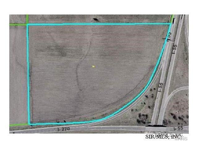
Property Detail
Maple Grove Rd
St. Louis, MO-IL
SW NW EXC
10-1-16-32-00-000-004
MADISON
Agriculturalland
Illinois
2025
30.13 AC
2025
Illinois
403121
St. Louis
NEARBY LISTINGS FOR SALE OR LEASE
DEMOGRAPHICS near Maple Grove Rd
1 mile
3 mile
5 mile
2025 Total Population
574
23,384
61,949
2030 Population
571
23,186
61,282
Pop Growth 2025-2030
(0.52%)
(0.85%)
(1.08%)
Average Age
43
41
41
2025 Total Households
217
9,031
24,123
HH Growth 2025-2030
(0.46%)
(0.91%)
(1.11%)
Median Household Inc
$112,500
$107,226
$103,216
Avg Household Size
2.50
2.50
2.50
2025 Avg HH Vehicles
2.00
2.00
2.00
Median Home Value
$297,886
$297,797
$288,013
Median Year Built
1998
1992
1987
Nearby Places
Map Layers
Map Styles
 Street
 Aerial
Layers
 Traffic
 Biking
Places
Listings with unknown addresses are not visible on the map
- Restaurants
- Banks
- Shops
- Fitness
- Groceries
PUBLIC TRANSPORTATION
AIRPORT
St Louis Lambert International
Drive
Walk
Distance
St Louis Lambert International
34 min
26.4 mi
Scott AFB/Midamerica St Louis
Drive
Walk
Distance
Scott AFB/Midamerica St Louis
43 min
27.2 mi
Freight Ports
Port Milwaukee
Drive
Walk
Distance
Port Milwaukee
400 min
355.7 mi
SALE & LEASE HISTORY
LISTING DATE
SALE/LEASE

Sep 24, 2016
For Sale
Nearby Properties
Address
Land Use
TOTAL SIZE
Lot Size
Zoning
Address
Land Use
TOTAL SIZE
Lot Size
Zoning
56,126 SF
10 AC
Address
Land Use
TOTAL SIZE
Lot Size
Zoning
10.83 AC
Address
Land Use
TOTAL SIZE
Lot Size
Zoning
218,837 SF
4.81 AC
Address
Land Use
TOTAL SIZE
Lot Size
Zoning
50,968 SF
4.23 AC
Address
Land Use
TOTAL SIZE
Lot Size
Zoning
25,675 SF
3 AC
Address
Land Use
TOTAL SIZE
Lot Size
Zoning
190,744 SF
12.47 AC
Address
Land Use
TOTAL SIZE
Lot Size
Zoning
22,816 SF
40.45 AC
Address
Land Use
TOTAL SIZE
Lot Size
Zoning
30,834 SF
6.41 AC
Address
Land Use
TOTAL SIZE
Lot Size
Zoning
127,592 SF
11.63 AC
Address
Land Use
TOTAL SIZE
Lot Size
Zoning
37,432 SF
2 AC
Address
Land Use
TOTAL SIZE
Lot Size
Zoning
59,848 SF
19.64 AC
Address
Land Use
TOTAL SIZE
Lot Size
Zoning
93,098 SF
15.82 AC
Address
Land Use
TOTAL SIZE
Lot Size
Zoning
89,378 SF
8.56 AC
Address
Land Use
TOTAL SIZE
Lot Size
Zoning
72,233 SF
4.94 AC
Address
Land Use
TOTAL SIZE
Lot Size
Zoning
46,916 SF
2.58 AC
Address
Land Use
TOTAL SIZE
Lot Size
Zoning
35,046 SF
6.82 AC
Address
Land Use
TOTAL SIZE
Lot Size
Zoning
3,620 SF
18 AC
Address
Land Use
TOTAL SIZE
Lot Size
Zoning
48,263 SF
6.64 AC
Address
Land Use
TOTAL SIZE
Lot Size
Zoning
36,845 SF
4 AC
Address
Land Use
TOTAL SIZE
Lot Size
Zoning
114,080 SF
10.18 AC
Address
Land Use
TOTAL SIZE
Lot Size
Zoning
94,310 SF
12.29 AC
Address
Land Use
TOTAL SIZE
Lot Size
Zoning
17,782 SF
2.50 AC
Address
Land Use
TOTAL SIZE
Lot Size
Zoning
96,702 SF
4.80 AC
Address
Land Use
TOTAL SIZE
Lot Size
Zoning
8,110 SF
13.83 AC
Address
Land Use
TOTAL SIZE
Lot Size
Zoning
37.86 AC
Address
Land Use
TOTAL SIZE
Lot Size
Zoning
2,262 SF
4.76 AC
Address
Land Use
TOTAL SIZE
Lot Size
Zoning
33,476 SF
Address
Land Use
TOTAL SIZE
Lot Size
Zoning
7,150 SF
7.63 AC
Address
Land Use
TOTAL SIZE
Lot Size
Zoning
31,024 SF
11.62 AC
Address
Land Use
TOTAL SIZE
Lot Size
Zoning
12,751 SF
0.68 AC
The World's #1 Commercial Real Estate Marketplace
Connect with us
© 2026 CoStar Group
The information above has been obtained from sources believed reliable. While we do not doubt its accuracy we have not verified it and make no guarantee, warranty or representation about it. It is your responsibility to independently confirm its accuracy and completeness. Any projections, opinions, assumptions, or estimates used are for example only and do not represent the current or future performance of the property. The value of this transaction to you depends on tax and other factors which should be evaluated by your tax, financial, and legal advisors. You and your advisors should conduct a careful, independent investigation of the property to determine to your satisfaction the suitability of the property for your needs.