Property Record
Maple Park Dr, Maple Hts, OH 44137
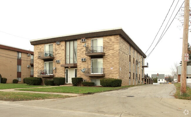
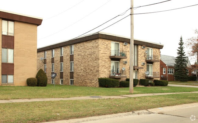
Property Detail
Maple Park Dr
Cleveland-Elyria, OH
32 EP 807.55 FT WP
786-03-043
CUYAHOGA
Apartment
Ohio
RMF
32
B and X Area of moderate flood hazard, usually the area between the limits of the 100-year and 500-year floods.
0.24 AC
2025
Maple Heights
2025
Cleveland
171102
NEARBY LISTINGS FOR SALE OR LEASE
-
-
View all Maple Hts listings for sale on LoopNet.com
DEMOGRAPHICS near Maple Park Dr
1 mile
3 mile
5 mile
2025 Total Population
14,385
70,006
182,811
2030 Population
14,341
69,575
181,237
Pop Growth 2025-2030
(0.31%)
(0.62%)
(0.86%)
Average Age
42
42
42
2025 Total Households
6,490
30,293
79,121
HH Growth 2025-2030
(0.34%)
(0.72%)
(1.00%)
Median Household Inc
$54,137
$55,552
$55,002
Avg Household Size
2.10
2.20
2.20
2025 Avg HH Vehicles
1.00
2.00
2.00
Median Home Value
$119,630
$111,274
$132,784
Median Year Built
1957
1955
1954
Nearby Places
Map Layers
Map Styles
 Street
 Aerial
Transit
 Traffic
 Biking
Places
Listings with unknown addresses are not visible on the map
- Restaurants
- Banks
- Shops
- Fitness
- Groceries
PUBLIC TRANSPORTATION
COMMUTER RAIL
Drive
Walk
Distance
10 min
3.6 mi
Drive
Walk
Distance
10 min
3.8 mi
AIRPORT
Cleveland-Hopkins International
Drive
Walk
Distance
Cleveland-Hopkins International
29 min
17.0 mi
Akron-Canton Regional
Drive
Walk
Distance
Akron-Canton Regional
55 min
39.0 mi
Nearby Properties
Address
Land Use
TOTAL SIZE
Lot Size
Zoning
Address
Land Use
TOTAL SIZE
Lot Size
Zoning
32,400 SF
52.29 AC
U-4
Address
Land Use
TOTAL SIZE
Lot Size
Zoning
68.97 AC
C-1
Address
Land Use
TOTAL SIZE
Lot Size
Zoning
186,275 SF
17.80 AC
U-8
Address
Land Use
TOTAL SIZE
Lot Size
Zoning
129,112 SF
24.11 AC
U-8
Address
Land Use
TOTAL SIZE
Lot Size
Zoning
289,009 SF
25.27 AC
I/O
Address
Land Use
TOTAL SIZE
Lot Size
Zoning
248,498 SF
14.31 AC
U-8
Address
Land Use
TOTAL SIZE
Lot Size
Zoning
227,141 SF
23.76 AC
U-4
Address
Land Use
TOTAL SIZE
Lot Size
Zoning
11,808 SF
900.50 AC
1F-2
Address
Land Use
TOTAL SIZE
Lot Size
Zoning
205,724 SF
6.54 AC
U-8
Address
Land Use
TOTAL SIZE
Lot Size
Zoning
18.38 AC
R2
Address
Land Use
TOTAL SIZE
Lot Size
Zoning
12.64 AC
U-4
Address
Land Use
TOTAL SIZE
Lot Size
Zoning
189,156 SF
24.49 AC
IG
Address
Land Use
TOTAL SIZE
Lot Size
Zoning
120,722 SF
20.55 AC
I/O
Address
Land Use
TOTAL SIZE
Lot Size
Zoning
14.95 AC
I-1
Address
Land Use
TOTAL SIZE
Lot Size
Zoning
105,215 SF
5.42 AC
PF
Address
Land Use
TOTAL SIZE
Lot Size
Zoning
137,795 SF
37.09 AC
R-4
Address
Land Use
TOTAL SIZE
Lot Size
Zoning
347,218 SF
0.23 AC
O/I
Address
Land Use
TOTAL SIZE
Lot Size
Zoning
65,108 SF
24.93 AC
I/O
Address
Land Use
TOTAL SIZE
Lot Size
Zoning
69,033 SF
8.85 AC
R-3
Address
Land Use
TOTAL SIZE
Lot Size
Zoning
133,913 SF
18.36 AC
U-11B
Address
Land Use
TOTAL SIZE
Lot Size
Zoning
8.60 AC
U-4
Address
Land Use
TOTAL SIZE
Lot Size
Zoning
15,154 SF
9.24 AC
SI
Address
Land Use
TOTAL SIZE
Lot Size
Zoning
350,592 SF
25.29 AC
O/I
Address
Land Use
TOTAL SIZE
Lot Size
Zoning
336,730 SF
38.51 AC
U-11A
Address
Land Use
TOTAL SIZE
Lot Size
Zoning
15.46 AC
Address
Land Use
TOTAL SIZE
Lot Size
Zoning
164,157 SF
6.29 AC
BP
Address
Land Use
TOTAL SIZE
Lot Size
Zoning
4,160 SF
1.84 AC
U-6
Address
Land Use
TOTAL SIZE
Lot Size
Zoning
373,099 SF
6.83 AC
R-3
Address
Land Use
TOTAL SIZE
Lot Size
Zoning
192,371 SF
22.06 AC
B3
Address
Land Use
TOTAL SIZE
Lot Size
Zoning
173,110 SF
6.38 AC
U-8
The World's #1 Commercial Real Estate Marketplace
Connect with us
© 2026 CoStar Group
The information above has been obtained from sources believed reliable. While we do not doubt its accuracy we have not verified it and make no guarantee, warranty or representation about it. It is your responsibility to independently confirm its accuracy and completeness. Any projections, opinions, assumptions, or estimates used are for example only and do not represent the current or future performance of the property. The value of this transaction to you depends on tax and other factors which should be evaluated by your tax, financial, and legal advisors. You and your advisors should conduct a careful, independent investigation of the property to determine to your satisfaction the suitability of the property for your needs.