Property Record
Maple St, Wapakoneta, OH 45895
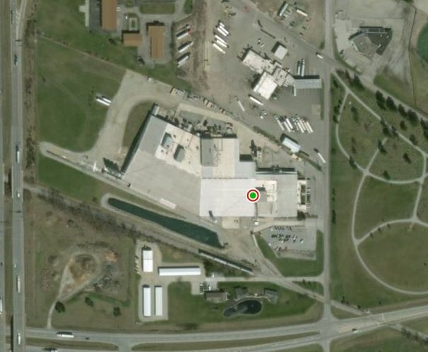
Property Detail
Maple St
Wapakoneta, OH
PT SE SE
B07-841-132-00
AUGLAIZE
Industrialgeneral
Ohio
B and X Area of moderate flood hazard, usually the area between the limits of the 100-year and 500-year floods.
7.97 AC
2024
Lima/Findlay
2025
Other Market Areas
040200
NEARBY LISTINGS FOR SALE OR LEASE
DEMOGRAPHICS near Maple St
1 mile
3 mile
5 mile
2025 Total Population
676
10,557
14,000
2030 Population
680
10,494
13,875
Pop Growth 2025-2030
+ 0.59%
(0.60%)
(0.89%)
Average Age
41
40
41
2025 Total Households
275
4,387
5,750
HH Growth 2025-2030
+ 0.73%
(0.62%)
(0.89%)
Median Household Inc
$65,172
$62,902
$69,236
Avg Household Size
2.40
2.30
2.40
2025 Avg HH Vehicles
2.00
2.00
2.00
Median Home Value
$151,442
$161,494
$174,401
Median Year Built
1974
1972
1973
Nearby Places
Map Layers
Map Styles
 Street
 Aerial
Transit
 Traffic
 Biking
Places
Listings with unknown addresses are not visible on the map
- Restaurants
- Banks
- Shops
- Fitness
- Groceries
SALE & LEASE HISTORY
LISTING DATE
SALE/LEASE

Mar 06, 2020
For Sale
Nearby Properties
Address
Land Use
TOTAL SIZE
Lot Size
Zoning
Address
Land Use
TOTAL SIZE
Lot Size
Zoning
7,752 SF
17.72 AC
Address
Land Use
TOTAL SIZE
Lot Size
Zoning
708,649 SF
51.89 AC
Address
Land Use
TOTAL SIZE
Lot Size
Zoning
15,244 SF
24.61 AC
Address
Land Use
TOTAL SIZE
Lot Size
Zoning
Address
Land Use
TOTAL SIZE
Lot Size
Zoning
252,038 SF
59.99 AC
Address
Land Use
TOTAL SIZE
Lot Size
Zoning
21.27 AC
Address
Land Use
TOTAL SIZE
Lot Size
Zoning
156,821 SF
18.78 AC
Address
Land Use
TOTAL SIZE
Lot Size
Zoning
14.74 AC
Address
Land Use
TOTAL SIZE
Lot Size
Zoning
110,719 SF
16.49 AC
Address
Land Use
TOTAL SIZE
Lot Size
Zoning
13.66 AC
Address
Land Use
TOTAL SIZE
Lot Size
Zoning
11,420 SF
46.64 AC
Address
Land Use
TOTAL SIZE
Lot Size
Zoning
323,534 SF
24.12 AC
Address
Land Use
TOTAL SIZE
Lot Size
Zoning
133,052 SF
14.08 AC
Address
Land Use
TOTAL SIZE
Lot Size
Zoning
193,070 SF
37.70 AC
Address
Land Use
TOTAL SIZE
Lot Size
Zoning
231,551 SF
8.06 AC
Address
Land Use
TOTAL SIZE
Lot Size
Zoning
7.94 AC
Address
Land Use
TOTAL SIZE
Lot Size
Zoning
1.09 AC
Address
Land Use
TOTAL SIZE
Lot Size
Zoning
60,142 SF
6.80 AC
Address
Land Use
TOTAL SIZE
Lot Size
Zoning
126,000 SF
5.78 AC
Address
Land Use
TOTAL SIZE
Lot Size
Zoning
17,717 SF
13.76 AC
Address
Land Use
TOTAL SIZE
Lot Size
Zoning
40,516 SF
5.09 AC
Address
Land Use
TOTAL SIZE
Lot Size
Zoning
Address
Land Use
TOTAL SIZE
Lot Size
Zoning
121,944 SF
80.95 AC
Address
Land Use
TOTAL SIZE
Lot Size
Zoning
84,726 SF
23.15 AC
Address
Land Use
TOTAL SIZE
Lot Size
Zoning
133,926 SF
4.61 AC
Address
Land Use
TOTAL SIZE
Lot Size
Zoning
15,074 SF
6.81 AC
Address
Land Use
TOTAL SIZE
Lot Size
Zoning
94,688 SF
8.05 AC
Address
Land Use
TOTAL SIZE
Lot Size
Zoning
25,381 SF
2.05 AC
Address
Land Use
TOTAL SIZE
Lot Size
Zoning
52,816 SF
8.58 AC
Address
Land Use
TOTAL SIZE
Lot Size
Zoning
8,091 SF
4.65 AC
The World's #1 Commercial Real Estate Marketplace
Connect with us
© 2026 CoStar Group
The information above has been obtained from sources believed reliable. While we do not doubt its accuracy we have not verified it and make no guarantee, warranty or representation about it. It is your responsibility to independently confirm its accuracy and completeness. Any projections, opinions, assumptions, or estimates used are for example only and do not represent the current or future performance of the property. The value of this transaction to you depends on tax and other factors which should be evaluated by your tax, financial, and legal advisors. You and your advisors should conduct a careful, independent investigation of the property to determine to your satisfaction the suitability of the property for your needs.