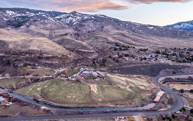
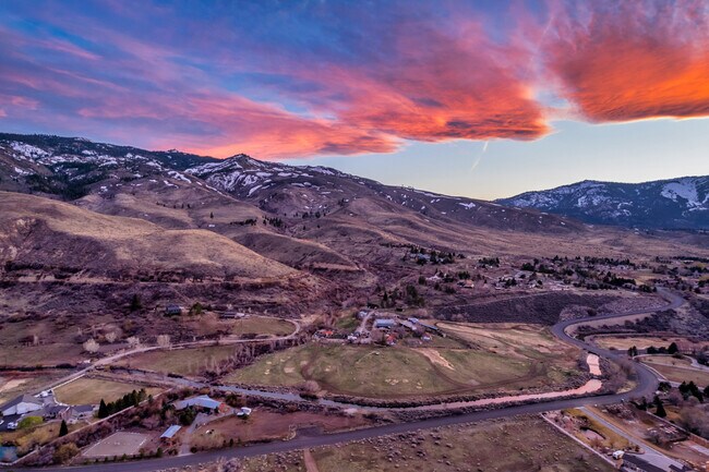
Property Record
Mario Rd, Reno, NV 89523
Property Detail
Mario Rd
Reno, NV
RS 4601 LT B
038-560-29
WASHOE
Residentialacreage
Nevada
HDR
b
B and X Area of moderate flood hazard, usually the area between the limits of the 100-year and 500-year floods.
2.16 AC
2025
S Outlying Washoe County
2026
Reno/Sparks
002302
NEARBY LISTINGS FOR SALE OR LEASE
-
-
View all Reno listings for sale on LoopNet.com
DEMOGRAPHICS near Mario Rd
1 mile
3 mile
5 mile
2025 Total Population
1,071
15,588
44,642
2030 Population
1,116
16,064
45,942
Pop Growth 2025-2030
+ 4.20%
+ 3.05%
+ 2.91%
Average Age
61
47
43
2025 Total Households
553
6,778
18,423
HH Growth 2025-2030
+ 4.52%
+ 3.25%
+ 3.04%
Median Household Inc
$115,937
$112,131
$106,538
Avg Household Size
1.90
2.30
2.40
2025 Avg HH Vehicles
2.00
2.00
2.00
Median Home Value
$711,152
$720,307
$712,626
Median Year Built
2010
2005
1998
Nearby Places
Map Layers
Map Styles
 Street
 Aerial
Transit
 Traffic
 Biking
Places
Listings with unknown addresses are not visible on the map
- Restaurants
- Banks
- Shops
- Fitness
- Groceries
PUBLIC TRANSPORTATION
AIRPORT
Reno/Tahoe International
Drive
Walk
Distance
Reno/Tahoe International
38 min
16.8 mi
Freight Ports
Port of Stockton
Drive
Walk
Distance
Port of Stockton
201 min
172.1 mi
SALE & LEASE HISTORY
LISTING DATE
SALE/LEASE

Apr 07, 2022
For Sale
Nearby Properties
Address
Land Use
TOTAL SIZE
Lot Size
Zoning
Address
Land Use
TOTAL SIZE
Lot Size
Zoning
331,462 SF
20.10 AC
PD
Address
Land Use
TOTAL SIZE
Lot Size
Zoning
252,869 SF
10.77 AC
MF14 97% /
Address
Land Use
TOTAL SIZE
Lot Size
Zoning
317,507 SF
19.43 AC
MF14
Address
Land Use
TOTAL SIZE
Lot Size
Zoning
359,209 SF
8.83 AC
HC
Address
Land Use
TOTAL SIZE
Lot Size
Zoning
260,382 SF
18.77 AC
PD
Address
Land Use
TOTAL SIZE
Lot Size
Zoning
342,672 SF
18.39 AC
MS
Address
Land Use
TOTAL SIZE
Lot Size
Zoning
257,834 SF
14.94 AC
MS
Address
Land Use
TOTAL SIZE
Lot Size
Zoning
127,616 SF
20.80 AC
AC
Address
Land Use
TOTAL SIZE
Lot Size
Zoning
221,000 SF
13.78 AC
IC
Address
Land Use
TOTAL SIZE
Lot Size
Zoning
170,090 SF
11.60 AC
MS 91% / S
Address
Land Use
TOTAL SIZE
Lot Size
Zoning
206,891 SF
13.81 AC
IC
Address
Land Use
TOTAL SIZE
Lot Size
Zoning
182,000 SF
13.56 AC
IC
Address
Land Use
TOTAL SIZE
Lot Size
Zoning
125,620 SF
12.96 AC
PF
Address
Land Use
TOTAL SIZE
Lot Size
Zoning
182,656 SF
10.50 AC
IC
Address
Land Use
TOTAL SIZE
Lot Size
Zoning
122,225 SF
5.85 AC
MS
Address
Land Use
TOTAL SIZE
Lot Size
Zoning
480.53 AC
PGOS 45% /
Address
Land Use
TOTAL SIZE
Lot Size
Zoning
440 AC
SF6 15% /
Address
Land Use
TOTAL SIZE
Lot Size
Zoning
115,848 SF
9.61 AC
PD
Address
Land Use
TOTAL SIZE
Lot Size
Zoning
14,540 SF
8.90 AC
HC
Address
Land Use
TOTAL SIZE
Lot Size
Zoning
43,394 SF
2.44 AC
PD
Address
Land Use
TOTAL SIZE
Lot Size
Zoning
6,793.88 AC
OS
Address
Land Use
TOTAL SIZE
Lot Size
Zoning
133,701 SF
21.38 AC
I
Address
Land Use
TOTAL SIZE
Lot Size
Zoning
23,438 SF
11.25 AC
MS
Address
Land Use
TOTAL SIZE
Lot Size
Zoning
67,200 SF
13.11 AC
MS
Address
Land Use
TOTAL SIZE
Lot Size
Zoning
89,226 SF
5.14 AC
MS
Address
Land Use
TOTAL SIZE
Lot Size
Zoning
2,438 SF
1.27 AC
OS 28%/PF
Address
Land Use
TOTAL SIZE
Lot Size
Zoning
15,000 SF
2.15 AC
PF
Address
Land Use
TOTAL SIZE
Lot Size
Zoning
22,703 SF
5.43 AC
GC
Address
Land Use
TOTAL SIZE
Lot Size
Zoning
91,786 SF
4.27 AC
MS
Address
Land Use
TOTAL SIZE
Lot Size
Zoning
242.86 AC
SF9 12% /
The World's #1 Commercial Real Estate Marketplace
Connect with us
© 2026 CoStar Group
The information above has been obtained from sources believed reliable. While we do not doubt its accuracy we have not verified it and make no guarantee, warranty or representation about it. It is your responsibility to independently confirm its accuracy and completeness. Any projections, opinions, assumptions, or estimates used are for example only and do not represent the current or future performance of the property. The value of this transaction to you depends on tax and other factors which should be evaluated by your tax, financial, and legal advisors. You and your advisors should conduct a careful, independent investigation of the property to determine to your satisfaction the suitability of the property for your needs.