Property Record
Marion Upper Sandusky Rd, Marion, OH 43302
NEARBY LISTINGS FOR SALE OR LEASE
-
-
View all Marion listings for sale on LoopNet.com
Property Detail
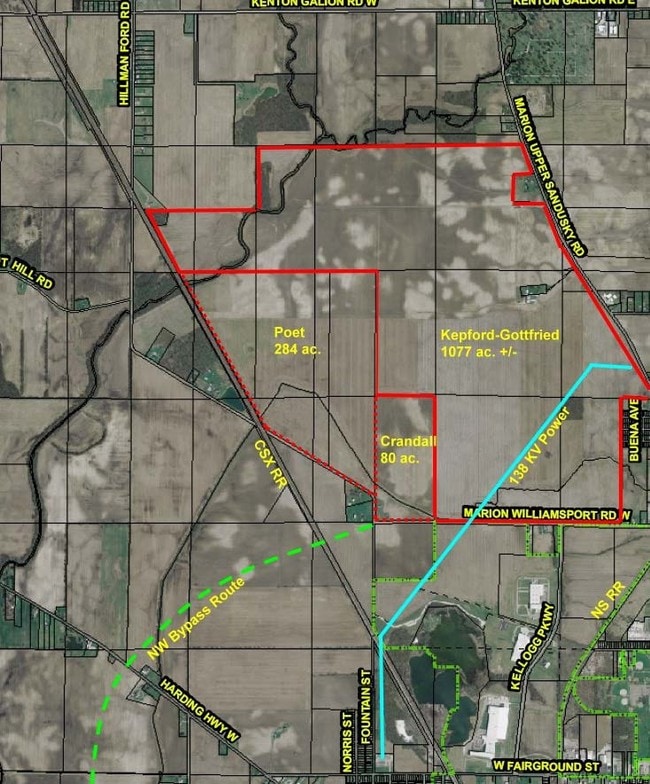
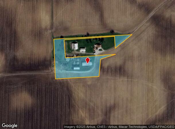
Marion Upper Sandusky Rd
19-0040012.000
PT NE NW SEC 9 MAP 1 AG DIST #39
Agriculturalland
Marion
X
Ohio
39101C0075E
3.29 AC
2024
Ohio North Area
2024
Other Market Areas
000502
Marion, OH
DEMOGRAPHICS near Marion Upper Sandusky Rd
1 Mile
3 Mile
5 Mile
2024 Total Population
155
17,621
43,151
2029 Population
155
17,800
43,263
Pop Growth 2024-2029
0.00%
+ 1.02%
+ 0.26%
Average Age
42
39
40
2024 Total Households
58
6,113
16,933
HH Growth 2024-2029
0.00%
+ 1.18%
+ 0.26%
Median Household Inc
$63,158
$37,782
$44,514
Avg Household Size
2.50
2.40
2.30
2024 Avg HH Vehicles
4.00
2.00
2.00
Median Home Value
$154,838
$72,484
$105,664
Median Year Built
1975
1953
1957
Nearby Places
Map Layers
Map Styles
 Street
 Aerial
- Restaurants
- Banks
- Shops
- Fitness
- Groceries
SALE & LEASE HISTORY
LISTING DATE
SALE/LEASE

Sep 24, 2016
For Sale
Jan 29, 2019
For Sale
Nearby Properties
Address
Land Use
TOTAL SIZE
Lot Size
Zoning
Address
Land Use
TOTAL SIZE
Lot Size
Zoning
882,546 SF
225.79 AC
Address
Land Use
TOTAL SIZE
Lot Size
Zoning
357,564 SF
143.16 AC
Address
Land Use
TOTAL SIZE
Lot Size
Zoning
262,750 SF
40.74 AC
Address
Land Use
TOTAL SIZE
Lot Size
Zoning
340,442 SF
47.81 AC
Address
Land Use
TOTAL SIZE
Lot Size
Zoning
24,627 SF
281.31 AC
Address
Land Use
TOTAL SIZE
Lot Size
Zoning
63,161 SF
10.02 AC
Address
Land Use
TOTAL SIZE
Lot Size
Zoning
645,332 SF
45.90 AC
Address
Land Use
TOTAL SIZE
Lot Size
Zoning
53,588 SF
10.57 AC
Address
Land Use
TOTAL SIZE
Lot Size
Zoning
131,589 SF
41.05 AC
Address
Land Use
TOTAL SIZE
Lot Size
Zoning
140,834 SF
16.63 AC
Address
Land Use
TOTAL SIZE
Lot Size
Zoning
58,756 SF
0.15 AC
Address
Land Use
TOTAL SIZE
Lot Size
Zoning
265,232 SF
17.45 AC
Address
Land Use
TOTAL SIZE
Lot Size
Zoning
433,652 SF
8.10 AC
Address
Land Use
TOTAL SIZE
Lot Size
Zoning
89,020 SF
13.91 AC
Address
Land Use
TOTAL SIZE
Lot Size
Zoning
143,935 SF
2.79 AC
Address
Land Use
TOTAL SIZE
Lot Size
Zoning
67,364 SF
22.52 AC
Address
Land Use
TOTAL SIZE
Lot Size
Zoning
204,848 SF
13.74 AC
Address
Land Use
TOTAL SIZE
Lot Size
Zoning
Address
Land Use
TOTAL SIZE
Lot Size
Zoning
44,125 SF
2.27 AC
Address
Land Use
TOTAL SIZE
Lot Size
Zoning
211,830 SF
15.56 AC
Address
Land Use
TOTAL SIZE
Lot Size
Zoning
2,184 SF
756.11 AC
Address
Land Use
TOTAL SIZE
Lot Size
Zoning
158,232 SF
9.99 AC
Address
Land Use
TOTAL SIZE
Lot Size
Zoning
6,188 SF
392.01 AC
Address
Land Use
TOTAL SIZE
Lot Size
Zoning
40,352 SF
6.73 AC
Address
Land Use
TOTAL SIZE
Lot Size
Zoning
14,836 SF
79.60 AC
Address
Land Use
TOTAL SIZE
Lot Size
Zoning
16,094 SF
0.80 AC
Address
Land Use
TOTAL SIZE
Lot Size
Zoning
23,384 SF
0.54 AC
Address
Land Use
TOTAL SIZE
Lot Size
Zoning
85,534 SF
13.88 AC
Address
Land Use
TOTAL SIZE
Lot Size
Zoning
72,300 SF
5.84 AC
Address
Land Use
TOTAL SIZE
Lot Size
Zoning
27,718 SF
0.25 AC
The World's #1 Commercial Real Estate Marketplace
Connect with us
© 2025 CoStar Group
The information above has been obtained from sources believed reliable. While we do not doubt its accuracy we have not verified it and make no guarantee, warranty or representation about it. It is your responsibility to independently confirm its accuracy and completeness. Any projections, opinions, assumptions, or estimates used are for example only and do not represent the current or future performance of the property. The value of this transaction to you depends on tax and other factors which should be evaluated by your tax, financial, and legal advisors. You and your advisors should conduct a careful, independent investigation of the property to determine to your satisfaction the suitability of the property for your needs.