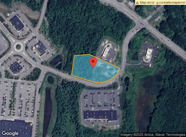
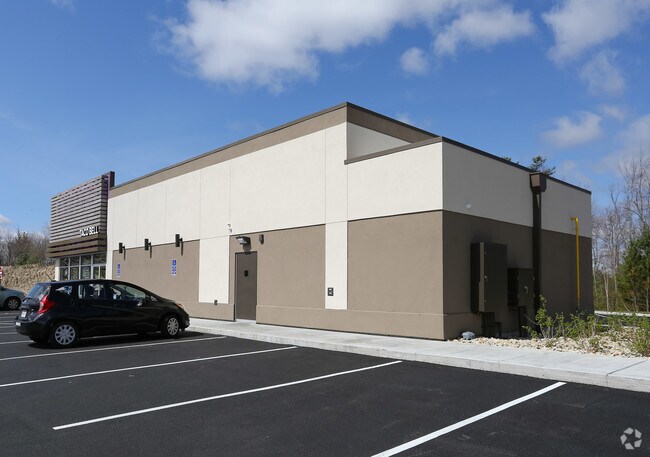
Property Record
Market Dr, Athol, MA 01331

NEARBY LISTINGS FOR SALE OR LEASE
Property Detail
Market Dr
ATHO M:00043 B:00087 L:00000
Worcester
Commercialacreage
Massachusetts
ARE
1.96 AC
25027C0183E
Outlying Worcester
2025
Boston
2025
Worcester, MA-CT
703100
DEMOGRAPHICS near Market Dr
1 Mile
3 Mile
5 Mile
2024 Total Population
473
10,383
17,276
2029 Population
480
10,453
17,389
Pop Growth 2024-2029
+ 1.48%
+ 0.67%
+ 0.65%
Average Age
43
42
43
2024 Total Households
190
4,236
7,044
HH Growth 2024-2029
+ 1.05%
+ 0.64%
+ 0.64%
Median Household Inc
$58,181
$58,989
$65,050
Avg Household Size
2.40
2.40
2.40
2024 Avg HH Vehicles
2.00
2.00
2.00
Median Home Value
$268,181
$236,443
$239,371
Median Year Built
1972
1954
1961
Nearby Places
Map Layers
Map Styles
 Street
 Aerial
- Restaurants
- Banks
- Shops
- Fitness
- Groceries
PUBLIC TRANSPORTATION
AIRPORT
Worcester Regional
DRIVE
WALK
Distance
Worcester Regional
62 min
34.4 mi
Freight Ports
Port of Boston
DRIVE
WALK
Distance
Port of Boston
101 min
68.8 mi
SALE & LEASE HISTORY
LISTING DATE
SALE/LEASE

Feb 28, 2019
For Sale
Nearby Properties
Address
Land Use
TOTAL SIZE
Lot Size
Zoning
Address
Land Use
TOTAL SIZE
Lot Size
Zoning
66,835 SF
12.39 AC
Address
Land Use
TOTAL SIZE
Lot Size
Zoning
76,943 SF
71.01 AC
Address
Land Use
TOTAL SIZE
Lot Size
Zoning
112,054 SF
10.48 AC
Address
Land Use
TOTAL SIZE
Lot Size
Zoning
22 AC
Address
Land Use
TOTAL SIZE
Lot Size
Zoning
66,766 SF
11 AC
Address
Land Use
TOTAL SIZE
Lot Size
Zoning
3.50 AC
Address
Land Use
TOTAL SIZE
Lot Size
Zoning
130,539 SF
Address
Land Use
TOTAL SIZE
Lot Size
Zoning
49,820 SF
0.75 AC
Address
Land Use
TOTAL SIZE
Lot Size
Zoning
27,129 SF
3 AC
Address
Land Use
TOTAL SIZE
Lot Size
Zoning
25,156 SF
4.80 AC
Address
Land Use
TOTAL SIZE
Lot Size
Zoning
30,327 SF
0.56 AC
Address
Land Use
TOTAL SIZE
Lot Size
Zoning
7.05 AC
Address
Land Use
TOTAL SIZE
Lot Size
Zoning
20,065 SF
Address
Land Use
TOTAL SIZE
Lot Size
Zoning
29,090 SF
0.57 AC
Address
Land Use
TOTAL SIZE
Lot Size
Zoning
10,204 SF
1.60 AC
Address
Land Use
TOTAL SIZE
Lot Size
Zoning
1,080.01 AC
Address
Land Use
TOTAL SIZE
Lot Size
Zoning
25,840 SF
5.99 AC
Address
Land Use
TOTAL SIZE
Lot Size
Zoning
61,096 SF
2.16 AC
Address
Land Use
TOTAL SIZE
Lot Size
Zoning
3.50 AC
Address
Land Use
TOTAL SIZE
Lot Size
Zoning
14,474 SF
1.03 AC
Address
Land Use
TOTAL SIZE
Lot Size
Zoning
67.28 AC
B
Address
Land Use
TOTAL SIZE
Lot Size
Zoning
2.10 AC
Address
Land Use
TOTAL SIZE
Lot Size
Zoning
14,723 SF
0.16 AC
Address
Land Use
TOTAL SIZE
Lot Size
Zoning
2.80 AC
Address
Land Use
TOTAL SIZE
Lot Size
Zoning
9,192 SF
0.82 AC
Address
Land Use
TOTAL SIZE
Lot Size
Zoning
32,286 SF
0.24 AC
Address
Land Use
TOTAL SIZE
Lot Size
Zoning
0.11 AC
Address
Land Use
TOTAL SIZE
Lot Size
Zoning
4,683 SF
9.88 AC
Address
Land Use
TOTAL SIZE
Lot Size
Zoning
6.10 AC
Address
Land Use
TOTAL SIZE
Lot Size
Zoning
14,573 SF
0.65 AC
The World's #1 Commercial Real Estate Marketplace
Connect with us
© 2025 CoStar Group
The information above has been obtained from sources believed reliable. While we do not doubt its accuracy we have not verified it and make no guarantee, warranty or representation about it. It is your responsibility to independently confirm its accuracy and completeness. Any projections, opinions, assumptions, or estimates used are for example only and do not represent the current or future performance of the property. The value of this transaction to you depends on tax and other factors which should be evaluated by your tax, financial, and legal advisors. You and your advisors should conduct a careful, independent investigation of the property to determine to your satisfaction the suitability of the property for your needs.