Property Record
Marshall Rd Sw, Winter Haven, FL 33880
Save to a Folder
{{folder.Name}}
{{folder.ListingIds.length}} Properties
{{folder.ListingIds.length}} Property
Create a New Folder
Property Detail
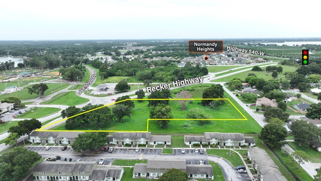
Marshall Rd Sw
Lakeland-Winter Haven, FL
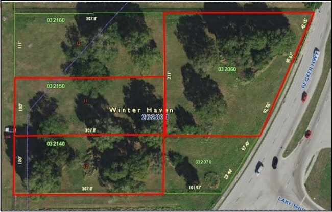
BEG 111 FT S OF NW COR OF SE1/4 OF SE1/4 OF NW1/4 RUN E 307.80 FT S 100 FT W 307.80 FT N 100 FT TO POB LESS RD R/W BEING LOT 11 OF UNREC SURVEY
26-28-31-000000-032140
POLK
Commercialacreage
Florida
BR
11
B and X Area of moderate flood hazard, usually the area between the limits of the 100-year and 500-year floods.
0.61 AC
2025
Polk County
2025
Tampa/St Petersburg
013802
NEARBY LISTINGS FOR SALE OR LEASE
DEMOGRAPHICS near Marshall Rd Sw
1 mile
3 mile
5 mile
2025 Total Population
8,063
55,477
112,709
2030 Population
9,150
63,305
128,764
Pop Growth 2025-2030
+ 13.48%
+ 14.11%
+ 14.24%
Average Age
38
40
40
2025 Total Households
3,049
21,585
43,073
HH Growth 2025-2030
+ 13.74%
+ 14.38%
+ 14.50%
Median Household Inc
$61,797
$62,158
$63,376
Avg Household Size
2.60
2.50
2.50
2025 Avg HH Vehicles
2.00
2.00
2.00
Median Home Value
$281,455
$264,047
$271,100
Median Year Built
1983
1979
1982
Nearby Places
Map Layers
Map Styles
 Street
 Aerial
Layers
 Traffic
 Biking
Places
Listings with unknown addresses are not visible on the map
- Restaurants
- Banks
- Shops
- Fitness
- Groceries
PUBLIC TRANSPORTATION
COMMUTER RAIL
Winter Haven (Floridian - Amtrak, Silver Meteor - Amtrak)
Drive
Walk
Distance
Winter Haven (Floridian - Amtrak, Silver Meteor - Amtrak)
4 min
1.9 mi
Freight Ports
Port of Tampa Bay
Drive
Walk
Distance
Port of Tampa Bay
63 min
48.3 mi
SALE & LEASE HISTORY
LISTING DATE
SALE/LEASE

Jul 22, 2024
For Sale
Feb 28, 2020
For Sale
Nearby Properties
Address
Land Use
TOTAL SIZE
Lot Size
Zoning
Address
Land Use
TOTAL SIZE
Lot Size
Zoning
728,846 SF
28.07 AC
Address
Land Use
TOTAL SIZE
Lot Size
Zoning
250,170 SF
24.21 AC
Address
Land Use
TOTAL SIZE
Lot Size
Zoning
504,548 SF
26.82 AC
BR
Address
Land Use
TOTAL SIZE
Lot Size
Zoning
215,942 SF
43.90 AC
Address
Land Use
TOTAL SIZE
Lot Size
Zoning
303,642 SF
96.19 AC
RC
Address
Land Use
TOTAL SIZE
Lot Size
Zoning
282,400 SF
19.59 AC
XX
Address
Land Use
TOTAL SIZE
Lot Size
Zoning
267,076 SF
31.67 AC
Address
Land Use
TOTAL SIZE
Lot Size
Zoning
85,378 SF
4.20 AC
BR
Address
Land Use
TOTAL SIZE
Lot Size
Zoning
75,936 SF
0.76 AC
R3
Address
Land Use
TOTAL SIZE
Lot Size
Zoning
155,373 SF
72.76 AC
Address
Land Use
TOTAL SIZE
Lot Size
Zoning
135,118 SF
7.26 AC
Address
Land Use
TOTAL SIZE
Lot Size
Zoning
200,200 SF
10.29 AC
Address
Land Use
TOTAL SIZE
Lot Size
Zoning
503,625 SF
20.61 AC
Address
Land Use
TOTAL SIZE
Lot Size
Zoning
221,590 SF
24.54 AC
Address
Land Use
TOTAL SIZE
Lot Size
Zoning
277,680 SF
43.76 AC
R1C
Address
Land Use
TOTAL SIZE
Lot Size
Zoning
322,165 SF
16.88 AC
Address
Land Use
TOTAL SIZE
Lot Size
Zoning
102,442 SF
10.73 AC
Address
Land Use
TOTAL SIZE
Lot Size
Zoning
188,403 SF
27.79 AC
BT
Address
Land Use
TOTAL SIZE
Lot Size
Zoning
123,540 SF
5.89 AC
Address
Land Use
TOTAL SIZE
Lot Size
Zoning
135,885 SF
10.12 AC
Address
Land Use
TOTAL SIZE
Lot Size
Zoning
102,307 SF
1.79 AC
RP
Address
Land Use
TOTAL SIZE
Lot Size
Zoning
77,388 SF
5.37 AC
BT
Address
Land Use
TOTAL SIZE
Lot Size
Zoning
173,328 SF
37.45 AC
C3
Address
Land Use
TOTAL SIZE
Lot Size
Zoning
109,512 SF
5 AC
Address
Land Use
TOTAL SIZE
Lot Size
Zoning
185,895 SF
16.16 AC
BR
Address
Land Use
TOTAL SIZE
Lot Size
Zoning
70,900 SF
1.62 AC
Address
Land Use
TOTAL SIZE
Lot Size
Zoning
57,387 SF
9.84 AC
RC
Address
Land Use
TOTAL SIZE
Lot Size
Zoning
90,200 SF
1.93 AC
RP
Address
Land Use
TOTAL SIZE
Lot Size
Zoning
122,752 SF
1.68 AC
Address
Land Use
TOTAL SIZE
Lot Size
Zoning
76,664 SF
18.64 AC
RP
The World's #1 Commercial Real Estate Marketplace
Connect with us
© 2026 CoStar Group
The information above has been obtained from sources believed reliable. While we do not doubt its accuracy we have not verified it and make no guarantee, warranty or representation about it. It is your responsibility to independently confirm its accuracy and completeness. Any projections, opinions, assumptions, or estimates used are for example only and do not represent the current or future performance of the property. The value of this transaction to you depends on tax and other factors which should be evaluated by your tax, financial, and legal advisors. You and your advisors should conduct a careful, independent investigation of the property to determine to your satisfaction the suitability of the property for your needs.