Property Record
Martin Line Rd, Tanner, AL 35671
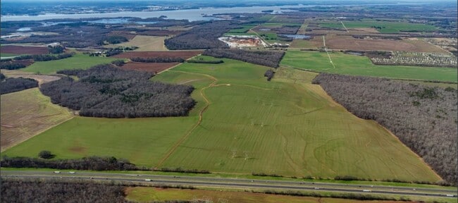


Property Detail
Martin Line Rd
Huntsville, AL
W/4 E/2 IN SEC 15 4 4ANNEXED INTO CITY OF HUNTSVILLE ORD #23-659
16-06-14-0-000-004.000
LIMESTONE
Cropfieldcropsrowcropsallsoilclasses
Alabama
B and X Area of moderate flood hazard, usually the area between the limits of the 100-year and 500-year floods.
138.50 AC
2025
Outlying Limestone County
2025
Huntsville
021101
NEARBY LISTINGS FOR SALE OR LEASE
DEMOGRAPHICS near Martin Line Rd
1 mile
3 mile
5 mile
2025 Total Population
0
1,593
7,505
2030 Population
0
1,801
8,482
Pop Growth 2025-2030
0.00%
+ 13.06%
+ 13.02%
Average Age
0
44
41
2025 Total Households
0
653
2,907
HH Growth 2025-2030
0.00%
+ 13.32%
+ 13.28%
Median Household Inc
$0
$81,338
$103,100
Avg Household Size
.00
2.40
2.60
2025 Avg HH Vehicles
.00
2.00
2.00
Median Home Value
$0
$368,749
$379,102
Median Year Built
0
1997
2004
Nearby Places
Map Layers
Map Styles
 Street
 Aerial
Layers
 Traffic
 Biking
Places
Listings with unknown addresses are not visible on the map
- Restaurants
- Banks
- Shops
- Fitness
- Groceries
PUBLIC TRANSPORTATION
AIRPORT
Huntsville International-Carl T Jones Field
Drive
Walk
Distance
Huntsville International-Carl T Jones Field
21 min
15.5 mi
Freight Ports
Port of Mobile
Drive
Walk
Distance
Port of Mobile
370 min
340.3 mi
SALE & LEASE HISTORY
LISTING DATE
SALE/LEASE

Feb 07, 2020
For Sale
Aug 29, 2022
For Sale
Nearby Properties
Address
Land Use
TOTAL SIZE
Lot Size
Zoning
Address
Land Use
TOTAL SIZE
Lot Size
Zoning
2,926 SF
190.98 AC
Address
Land Use
TOTAL SIZE
Lot Size
Zoning
55,196 SF
21.21 AC
Address
Land Use
TOTAL SIZE
Lot Size
Zoning
6,878 SF
139.27 AC
Address
Land Use
TOTAL SIZE
Lot Size
Zoning
2,156 SF
107 AC
Address
Land Use
TOTAL SIZE
Lot Size
Zoning
22.62 AC
Address
Land Use
TOTAL SIZE
Lot Size
Zoning
5,500 SF
8 AC
Address
Land Use
TOTAL SIZE
Lot Size
Zoning
27,360 SF
4.80 AC
Address
Land Use
TOTAL SIZE
Lot Size
Zoning
52,644 SF
10 AC
Address
Land Use
TOTAL SIZE
Lot Size
Zoning
196.30 AC
Address
Land Use
TOTAL SIZE
Lot Size
Zoning
13,504 SF
Address
Land Use
TOTAL SIZE
Lot Size
Zoning
18,462 SF
2.90 AC
Address
Land Use
TOTAL SIZE
Lot Size
Zoning
13,760 SF
Address
Land Use
TOTAL SIZE
Lot Size
Zoning
2,400 SF
19.86 AC
Address
Land Use
TOTAL SIZE
Lot Size
Zoning
17,196 SF
3 AC
Address
Land Use
TOTAL SIZE
Lot Size
Zoning
11,924 SF
3 AC
Address
Land Use
TOTAL SIZE
Lot Size
Zoning
700 SF
62 AC
Address
Land Use
TOTAL SIZE
Lot Size
Zoning
3,700 SF
1 AC
Address
Land Use
TOTAL SIZE
Lot Size
Zoning
10.60 AC
Address
Land Use
TOTAL SIZE
Lot Size
Zoning
146 AC
Address
Land Use
TOTAL SIZE
Lot Size
Zoning
1,560 SF
17.83 AC
Address
Land Use
TOTAL SIZE
Lot Size
Zoning
5,000 SF
1.30 AC
Address
Land Use
TOTAL SIZE
Lot Size
Zoning
119 AC
Address
Land Use
TOTAL SIZE
Lot Size
Zoning
0.70 AC
Address
Land Use
TOTAL SIZE
Lot Size
Zoning
9,000 SF
2.10 AC
Address
Land Use
TOTAL SIZE
Lot Size
Zoning
7,000 SF
1 AC
Address
Land Use
TOTAL SIZE
Lot Size
Zoning
4,800 SF
1.60 AC
Address
Land Use
TOTAL SIZE
Lot Size
Zoning
110 AC
Address
Land Use
TOTAL SIZE
Lot Size
Zoning
Address
Land Use
TOTAL SIZE
Lot Size
Zoning
4,500 SF
4 AC
Address
Land Use
TOTAL SIZE
Lot Size
Zoning
10,360 SF
0.75 AC
The World's #1 Commercial Real Estate Marketplace
Connect with us
© 2026 CoStar Group
The information above has been obtained from sources believed reliable. While we do not doubt its accuracy we have not verified it and make no guarantee, warranty or representation about it. It is your responsibility to independently confirm its accuracy and completeness. Any projections, opinions, assumptions, or estimates used are for example only and do not represent the current or future performance of the property. The value of this transaction to you depends on tax and other factors which should be evaluated by your tax, financial, and legal advisors. You and your advisors should conduct a careful, independent investigation of the property to determine to your satisfaction the suitability of the property for your needs.