Property Record
Mary Dr, Memphis, TN 38111

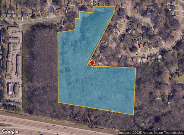
This Property Is For Sale
NEARBY LISTINGS FOR SALE OR LEASE
Property Detail
Mary Dr
05-8018-0-0162
ES ELLSWORTH COR STEVE (SE) SEE MAP GRID# 166 K
Vacantlandnec
Shelby
AE
Tennessee
47157C0430F
13.77 AC
2024
East
2025
Memphis
007000
Memphis, TN-MS-AR
DEMOGRAPHICS near Mary Dr
1 Mile
3 Mile
5 Mile
2024 Total Population
9,993
88,798
215,706
2029 Population
10,022
88,982
215,182
Pop Growth 2024-2029
+ 0.29%
+ 0.21%
(0.24%)
Average Age
36
36
37
2024 Total Households
3,769
35,510
87,975
HH Growth 2024-2029
+ 0.03%
+ 0.09%
(0.35%)
Median Household Inc
$38,547
$38,990
$44,132
Avg Household Size
2.60
2.40
2.40
2024 Avg HH Vehicles
1.00
1.00
2.00
Median Home Value
$60,443
$99,118
$173,104
Median Year Built
1957
1959
1961
Nearby Places
- Restaurants
- Banks
- Shops
- Fitness
- Groceries
PUBLIC TRANSPORTATION
COMMUTER RAIL
Central Station (Riverfront Loop - Memphis Area Transit Authority Trolley (MataTrolley))
DRIVE
WALK
Distance
Central Station (Riverfront Loop - Memphis Area Transit Authority Trolley (MataTrolley))
15 min
8.8 mi
AIRPORT
Memphis International
DRIVE
WALK
Distance
Memphis International
10 min
5.9 mi
Freight Ports
Port of Shreveport
DRIVE
WALK
Distance
Port of Shreveport
411 min
376.3 mi
Nearby Properties
Address
Land Use
TOTAL SIZE
Lot Size
Zoning
Address
Land Use
TOTAL SIZE
Lot Size
Zoning
189,536 SF
49.14 AC
CMU-2
Address
Land Use
TOTAL SIZE
Lot Size
Zoning
286,167 SF
18.91 AC
R-10
Address
Land Use
TOTAL SIZE
Lot Size
Zoning
190,263 SF
6.59 AC
R-10
Address
Land Use
TOTAL SIZE
Lot Size
Zoning
118,073 SF
4.75 AC
CMU-1
Address
Land Use
TOTAL SIZE
Lot Size
Zoning
2,847.82 AC
EMP
Address
Land Use
TOTAL SIZE
Lot Size
Zoning
188,458 SF
29.19 AC
RU-3
Address
Land Use
TOTAL SIZE
Lot Size
Zoning
87,283 SF
2.14 AC
CMU-1
Address
Land Use
TOTAL SIZE
Lot Size
Zoning
81,454 SF
EMP
Address
Land Use
TOTAL SIZE
Lot Size
Zoning
58.21 AC
R-6
Address
Land Use
TOTAL SIZE
Lot Size
Zoning
509,111 SF
EMP
Address
Land Use
TOTAL SIZE
Lot Size
Zoning
342,605 SF
82.99 AC
CA
Address
Land Use
TOTAL SIZE
Lot Size
Zoning
1,117,337 SF
127.15 AC
EMP
Address
Land Use
TOTAL SIZE
Lot Size
Zoning
15,370 SF
18.69 AC
RU-3
Address
Land Use
TOTAL SIZE
Lot Size
Zoning
55,250 SF
7.15 AC
CMU-3
Address
Land Use
TOTAL SIZE
Lot Size
Zoning
129 AC
CMP-1
Address
Land Use
TOTAL SIZE
Lot Size
Zoning
181.02 AC
R-15
Address
Land Use
TOTAL SIZE
Lot Size
Zoning
1,012,609 SF
38.67 AC
IH
Address
Land Use
TOTAL SIZE
Lot Size
Zoning
200,040 SF
12 AC
R-10
Address
Land Use
TOTAL SIZE
Lot Size
Zoning
369,190 SF
23.75 AC
EMP
Address
Land Use
TOTAL SIZE
Lot Size
Zoning
173,089 SF
10.92 AC
EMP
Address
Land Use
TOTAL SIZE
Lot Size
Zoning
81,516 SF
2.76 AC
RU-3
Address
Land Use
TOTAL SIZE
Lot Size
Zoning
71,308 SF
EMP
Address
Land Use
TOTAL SIZE
Lot Size
Zoning
66,841 SF
7.86 AC
CMU-3
Address
Land Use
TOTAL SIZE
Lot Size
Zoning
81,958 SF
0.98 AC
CMU-1
Address
Land Use
TOTAL SIZE
Lot Size
Zoning
62,022 SF
6.28 AC
EMP
Address
Land Use
TOTAL SIZE
Lot Size
Zoning
42,102 SF
18.74 AC
RU-3
Address
Land Use
TOTAL SIZE
Lot Size
Zoning
73,168 SF
1.38 AC
CMU-1
Address
Land Use
TOTAL SIZE
Lot Size
Zoning
191,168 SF
4.56 AC
CMP-1
Address
Land Use
TOTAL SIZE
Lot Size
Zoning
306,219 SF
12.11 AC
EMP
Address
Land Use
TOTAL SIZE
Lot Size
Zoning
36,148 SF
5.84 AC
R-15
The World's #1 Commercial Real Estate Marketplace
Connect with us
© 2025 CoStar Group
The information above has been obtained from sources believed reliable. While we do not doubt its accuracy we have not verified it and make no guarantee, warranty or representation about it. It is your responsibility to independently confirm its accuracy and completeness. Any projections, opinions, assumptions, or estimates used are for example only and do not represent the current or future performance of the property. The value of this transaction to you depends on tax and other factors which should be evaluated by your tax, financial, and legal advisors. You and your advisors should conduct a careful, independent investigation of the property to determine to your satisfaction the suitability of the property for your needs.