Property Record
Maugans Ave, Maugansville, MD 21767

Save to a Folder
{{folder.Name}}
{{folder.ListingIds.length}} Properties
{{folder.ListingIds.length}} Property
Create a New Folder
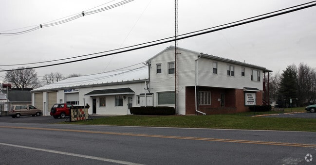
Property Detail
Maugans Ave
13-007969
PT LOT 10X110 N/S MAUGANS AVE
Commercialacreage
WASHINGTON
BG
Maryland
B and X Area of moderate flood hazard, usually the area between the limits of the 100-year and 500-year floods.
0.03 AC
2025
Washington County
2025
Washington, DC
010401
Hagerstown-Martinsburg, MD-WV
NEARBY LISTINGS FOR SALE OR LEASE
DEMOGRAPHICS near Maugans Ave
1 mile
3 mile
5 mile
2025 Total Population
3,861
25,596
72,419
2030 Population
3,860
25,988
73,848
Pop Growth 2025-2030
(0.03%)
+ 1.53%
+ 1.97%
Average Age
40
41
40
2025 Total Households
1,505
9,854
28,638
HH Growth 2025-2030
(0.07%)
+ 1.49%
+ 2.02%
Median Household Inc
$79,758
$88,255
$64,845
Avg Household Size
2.50
2.50
2.40
2025 Avg HH Vehicles
2.00
2.00
2.00
Median Home Value
$286,181
$287,097
$256,741
Median Year Built
1988
1979
1968
Nearby Places
Map Layers
Map Styles
 Street
 Aerial
Layers
 Traffic
 Biking
Places
Listings with unknown addresses are not visible on the map
- Restaurants
- Banks
- Shops
- Fitness
- Groceries
PUBLIC TRANSPORTATION
AIRPORT
Hagerstown Regional/Richard A Henson Field
Drive
Walk
Distance
Hagerstown Regional/Richard A Henson Field
5 min
1.7 mi
Freight Ports
Port of Baltimore
Drive
Walk
Distance
Port of Baltimore
100 min
83.7 mi
SALE & LEASE HISTORY
LISTING DATE
SALE/LEASE

Oct 27, 2021
For Sale
Nearby Properties
Address
Land Use
TOTAL SIZE
Lot Size
Zoning
Address
Land Use
TOTAL SIZE
Lot Size
Zoning
1,190,700 SF
83.26 AC
HI
Address
Land Use
TOTAL SIZE
Lot Size
Zoning
23,941 SF
401.89 AC
U
Address
Land Use
TOTAL SIZE
Lot Size
Zoning
801,000 SF
86.86 AC
HI
Address
Land Use
TOTAL SIZE
Lot Size
Zoning
36,685 SF
281.72 AC
IG
Address
Land Use
TOTAL SIZE
Lot Size
Zoning
151,660 SF
56.24 AC
RMOD
Address
Land Use
TOTAL SIZE
Lot Size
Zoning
117,096 SF
28.13 AC
CR
Address
Land Use
TOTAL SIZE
Lot Size
Zoning
127,315 SF
26.65 AC
RMOD
Address
Land Use
TOTAL SIZE
Lot Size
Zoning
76,740 SF
16.01 AC
CG
Address
Land Use
TOTAL SIZE
Lot Size
Zoning
6,778 SF
8.24 AC
RH
Address
Land Use
TOTAL SIZE
Lot Size
Zoning
91,586 SF
28.49 AC
U
Address
Land Use
TOTAL SIZE
Lot Size
Zoning
65,433 SF
16.52 AC
PUD
Address
Land Use
TOTAL SIZE
Lot Size
Zoning
5,090 SF
25.27 AC
RMOD
Address
Land Use
TOTAL SIZE
Lot Size
Zoning
3,984 SF
18.32 AC
CR
Address
Land Use
TOTAL SIZE
Lot Size
Zoning
123,120 SF
28.54 AC
ORT
Address
Land Use
TOTAL SIZE
Lot Size
Zoning
150,000 SF
22.73 AC
HI
Address
Land Use
TOTAL SIZE
Lot Size
Zoning
764,619 SF
31.10 AC
IG
Address
Land Use
TOTAL SIZE
Lot Size
Zoning
35,402 SF
10.18 AC
BG
Address
Land Use
TOTAL SIZE
Lot Size
Zoning
79,084 SF
12.50 AC
RMOD
Address
Land Use
TOTAL SIZE
Lot Size
Zoning
84,796 SF
8.81 AC
PB
Address
Land Use
TOTAL SIZE
Lot Size
Zoning
51,773 SF
11.96 AC
HI
Address
Land Use
TOTAL SIZE
Lot Size
Zoning
36,000 SF
12.07 AC
RM
Address
Land Use
TOTAL SIZE
Lot Size
Zoning
188,784 SF
79.06 AC
AP
Address
Land Use
TOTAL SIZE
Lot Size
Zoning
351,104 SF
55.68 AC
AP
Address
Land Use
TOTAL SIZE
Lot Size
Zoning
6,300 SF
35.92 AC
RT
Address
Land Use
TOTAL SIZE
Lot Size
Zoning
102,782 SF
12.92 AC
RMOD
Address
Land Use
TOTAL SIZE
Lot Size
Zoning
116,371 SF
10.18 AC
CR
Address
Land Use
TOTAL SIZE
Lot Size
Zoning
12,908 SF
12.94 AC
HI
Address
Land Use
TOTAL SIZE
Lot Size
Zoning
287,625 SF
19.69 AC
IG
Address
Land Use
TOTAL SIZE
Lot Size
Zoning
20,312 SF
17.59 AC
U
Address
Land Use
TOTAL SIZE
Lot Size
Zoning
21,483 SF
3.51 AC
HI
The World's #1 Commercial Real Estate Marketplace
Connect with us
© 2026 CoStar Group
The information above has been obtained from sources believed reliable. While we do not doubt its accuracy we have not verified it and make no guarantee, warranty or representation about it. It is your responsibility to independently confirm its accuracy and completeness. Any projections, opinions, assumptions, or estimates used are for example only and do not represent the current or future performance of the property. The value of this transaction to you depends on tax and other factors which should be evaluated by your tax, financial, and legal advisors. You and your advisors should conduct a careful, independent investigation of the property to determine to your satisfaction the suitability of the property for your needs.