Property Record
Maxwell Rd, Carleton, MI 48117

Property Detail
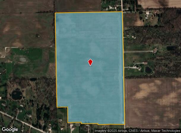
Maxwell Rd
01-030-053-02
SE4 T05S R09E
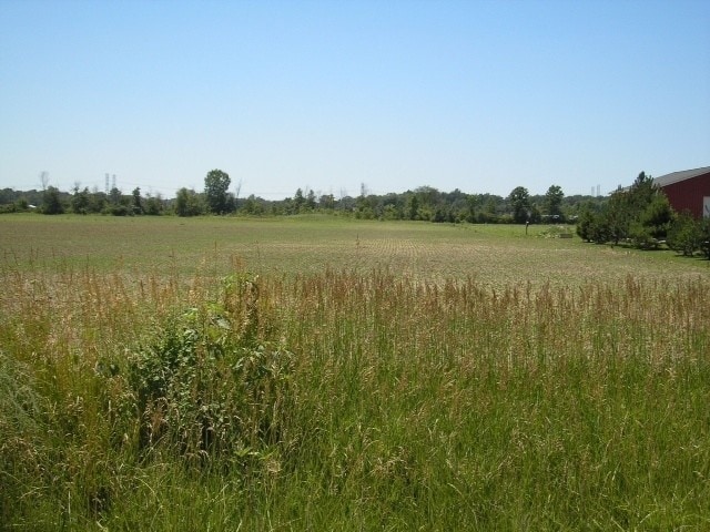
Agriculturalland
Monroe
A
Michigan
26115C0094E
64.72 AC
2025
Monroe County
2025
Detroit
830400
Monroe, MI
NEARBY LISTINGS FOR SALE OR LEASE
DEMOGRAPHICS near Maxwell Rd
1 mile
3 mile
5 mile
2024 Total Population
360
8,700
21,410
2029 Population
359
8,855
21,844
Pop Growth 2024-2029
(0.28%)
+ 1.78%
+ 2.03%
Average Age
46
41
41
2024 Total Households
141
3,464
8,339
HH Growth 2024-2029
(0.71%)
+ 1.85%
+ 2.06%
Median Household Inc
$88,095
$56,732
$66,765
Avg Household Size
2.50
2.50
2.50
2024 Avg HH Vehicles
2.00
2.00
2.00
Median Home Value
$319,791
$181,015
$215,000
Median Year Built
1975
1985
1989
Nearby Places
Map Layers
Map Styles
 Street
 Aerial
Transit
 Traffic
 Biking
Places
Listings with unknown addresses are not visible on the map
- Restaurants
- Banks
- Shops
- Fitness
- Groceries
PUBLIC TRANSPORTATION
AIRPORT
Detroit Metro Wayne County
Drive
Walk
Distance
Detroit Metro Wayne County
24 min
15.9 mi
Windsor International
Drive
Walk
Distance
Windsor International
66 min
40.0 mi
Freight Ports
Port of Toledo
Drive
Walk
Distance
Port of Toledo
49 min
33.9 mi
SALE & LEASE HISTORY
LISTING DATE
SALE/LEASE

Sep 28, 2017
For Sale
Nearby Properties
Address
Land Use
TOTAL SIZE
Lot Size
Zoning
Address
Land Use
TOTAL SIZE
Lot Size
Zoning
Address
Land Use
TOTAL SIZE
Lot Size
Zoning
249,112 SF
Address
Land Use
TOTAL SIZE
Lot Size
Zoning
5,216 SF
81.10 AC
MHP
Address
Land Use
TOTAL SIZE
Lot Size
Zoning
41,920 SF
48.72 AC
Address
Land Use
TOTAL SIZE
Lot Size
Zoning
40,101 SF
12.60 AC
Address
Land Use
TOTAL SIZE
Lot Size
Zoning
2,100 SF
36.48 AC
MHP
Address
Land Use
TOTAL SIZE
Lot Size
Zoning
3,954 SF
36.96 AC
MHP
Address
Land Use
TOTAL SIZE
Lot Size
Zoning
26.52 AC
MHP
Address
Land Use
TOTAL SIZE
Lot Size
Zoning
2,520 SF
27.80 AC
MHP
Address
Land Use
TOTAL SIZE
Lot Size
Zoning
91,075 SF
9.07 AC
Address
Land Use
TOTAL SIZE
Lot Size
Zoning
2,304 SF
50.50 AC
Address
Land Use
TOTAL SIZE
Lot Size
Zoning
39,078 SF
2.08 AC
Address
Land Use
TOTAL SIZE
Lot Size
Zoning
2,472 SF
46.65 AC
Address
Land Use
TOTAL SIZE
Lot Size
Zoning
37,665 SF
9.13 AC
Address
Land Use
TOTAL SIZE
Lot Size
Zoning
36,604 SF
3.96 AC
Address
Land Use
TOTAL SIZE
Lot Size
Zoning
9.80 AC
Address
Land Use
TOTAL SIZE
Lot Size
Zoning
3,488 SF
100.43 AC
Address
Land Use
TOTAL SIZE
Lot Size
Zoning
14,118 SF
37.23 AC
Address
Land Use
TOTAL SIZE
Lot Size
Zoning
6,106 SF
2.15 AC
Address
Land Use
TOTAL SIZE
Lot Size
Zoning
3,136 SF
3.92 AC
Address
Land Use
TOTAL SIZE
Lot Size
Zoning
9,146 SF
1.86 AC
Address
Land Use
TOTAL SIZE
Lot Size
Zoning
13,500 SF
2.34 AC
Address
Land Use
TOTAL SIZE
Lot Size
Zoning
28,800 SF
13.60 AC
Address
Land Use
TOTAL SIZE
Lot Size
Zoning
6.46 AC
Address
Land Use
TOTAL SIZE
Lot Size
Zoning
Address
Land Use
TOTAL SIZE
Lot Size
Zoning
7.24 AC
Address
Land Use
TOTAL SIZE
Lot Size
Zoning
21,832 SF
5.57 AC
Address
Land Use
TOTAL SIZE
Lot Size
Zoning
2,655 SF
65.26 AC
Address
Land Use
TOTAL SIZE
Lot Size
Zoning
Address
Land Use
TOTAL SIZE
Lot Size
Zoning
10.11 AC
The World's #1 Commercial Real Estate Marketplace
Connect with us
© 2026 CoStar Group
The information above has been obtained from sources believed reliable. While we do not doubt its accuracy we have not verified it and make no guarantee, warranty or representation about it. It is your responsibility to independently confirm its accuracy and completeness. Any projections, opinions, assumptions, or estimates used are for example only and do not represent the current or future performance of the property. The value of this transaction to you depends on tax and other factors which should be evaluated by your tax, financial, and legal advisors. You and your advisors should conduct a careful, independent investigation of the property to determine to your satisfaction the suitability of the property for your needs.