Property Record
Mayo Rd, Edgewater, MD 21037
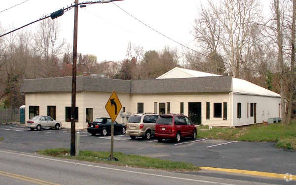

Property Detail
Mayo Rd
01-000-05286058
LT 5 BK B PL 1 COXBYS ESTATE
Officebuilding
ANNE ARUNDEL
C1B
Maryland
B and X Area of moderate flood hazard, usually the area between the limits of the 100-year and 500-year floods.
5
2024
1 AC
2025
Southern Anne Arundel
701202
Baltimore
6,720 SF
Baltimore-Columbia-Towson, MD
NEARBY LISTINGS FOR SALE OR LEASE
DEMOGRAPHICS near Mayo Rd
1 mile
3 mile
5 mile
2024 Total Population
1,547
22,482
79,895
2029 Population
1,570
22,748
81,273
Pop Growth 2024-2029
+ 1.49%
+ 1.18%
+ 1.72%
Average Age
41
42
42
2024 Total Households
555
8,398
31,817
HH Growth 2024-2029
+ 1.44%
+ 1.18%
+ 1.83%
Median Household Inc
$151,124
$124,325
$120,894
Avg Household Size
2.70
2.60
2.40
2024 Avg HH Vehicles
3.00
2.00
2.00
Median Home Value
$619,658
$544,315
$604,181
Median Year Built
1988
1980
1981
Nearby Places
Map Layers
Map Styles
 Street
 Aerial
Transit
 Traffic
 Biking
Places
Listings with unknown addresses are not visible on the map
- Restaurants
- Banks
- Shops
- Fitness
- Groceries
PUBLIC TRANSPORTATION
AIRPORT
Baltimore/Washington International Thurgood Marshall
Drive
Walk
Distance
Baltimore/Washington International Thurgood Marshall
40 min
27.3 mi
Ronald Reagan Washington Ntl
Drive
Walk
Distance
Ronald Reagan Washington Ntl
52 min
32.7 mi
Freight Ports
Port of Baltimore
Drive
Walk
Distance
Port of Baltimore
47 min
32.9 mi
Nearby Properties
Address
Land Use
TOTAL SIZE
Lot Size
Zoning
Address
Land Use
TOTAL SIZE
Lot Size
Zoning
589,210 SF
111.38 AC
RA
Address
Land Use
TOTAL SIZE
Lot Size
Zoning
112,662 SF
14.44 AC
C3
Address
Land Use
TOTAL SIZE
Lot Size
Zoning
77,261 SF
3.56 AC
C3
Address
Land Use
TOTAL SIZE
Lot Size
Zoning
94,932 SF
9.52 AC
C4
Address
Land Use
TOTAL SIZE
Lot Size
Zoning
15,093 SF
336.13 AC
R2
Address
Land Use
TOTAL SIZE
Lot Size
Zoning
61,141 SF
5.05 AC
C3
Address
Land Use
TOTAL SIZE
Lot Size
Zoning
62,532 SF
10.07 AC
C3
Address
Land Use
TOTAL SIZE
Lot Size
Zoning
48,572 SF
7.27 AC
R2
Address
Land Use
TOTAL SIZE
Lot Size
Zoning
15,000 SF
7.35 AC
C3
Address
Land Use
TOTAL SIZE
Lot Size
Zoning
55,348 SF
14.98 AC
R5
Address
Land Use
TOTAL SIZE
Lot Size
Zoning
39,568 SF
4.82 AC
C3
Address
Land Use
TOTAL SIZE
Lot Size
Zoning
46,664 SF
0.74 AC
C3
Address
Land Use
TOTAL SIZE
Lot Size
Zoning
23,890 SF
3.18 AC
C3
Address
Land Use
TOTAL SIZE
Lot Size
Zoning
25,142 SF
2.38 AC
C3
Address
Land Use
TOTAL SIZE
Lot Size
Zoning
55,649 SF
9.21 AC
R2
Address
Land Use
TOTAL SIZE
Lot Size
Zoning
15,007 SF
6.47 AC
C2
Address
Land Use
TOTAL SIZE
Lot Size
Zoning
38,004 SF
9.47 AC
R1
Address
Land Use
TOTAL SIZE
Lot Size
Zoning
117,528 SF
13.88 AC
C3
Address
Land Use
TOTAL SIZE
Lot Size
Zoning
31,363 SF
8.83 AC
R10
Address
Land Use
TOTAL SIZE
Lot Size
Zoning
19,026 SF
2.69 AC
MC
Address
Land Use
TOTAL SIZE
Lot Size
Zoning
40,462 SF
2.03 AC
C2
Address
Land Use
TOTAL SIZE
Lot Size
Zoning
4,795 SF
2.34 AC
MB
Address
Land Use
TOTAL SIZE
Lot Size
Zoning
106,824 SF
3.42 AC
C3
Address
Land Use
TOTAL SIZE
Lot Size
Zoning
45,704 SF
3 AC
C3
Address
Land Use
TOTAL SIZE
Lot Size
Zoning
12,288 SF
3.66 AC
C2
Address
Land Use
TOTAL SIZE
Lot Size
Zoning
17,414 SF
2.61 AC
C3
Address
Land Use
TOTAL SIZE
Lot Size
Zoning
73,123 SF
6.59 AC
C3
Address
Land Use
TOTAL SIZE
Lot Size
Zoning
5,984 SF
2.71 AC
C3
Address
Land Use
TOTAL SIZE
Lot Size
Zoning
5,498 SF
17.69 AC
MB
Address
Land Use
TOTAL SIZE
Lot Size
Zoning
10,976 SF
5.93 AC
C3
The World's #1 Commercial Real Estate Marketplace
Connect with us
© 2026 CoStar Group
The information above has been obtained from sources believed reliable. While we do not doubt its accuracy we have not verified it and make no guarantee, warranty or representation about it. It is your responsibility to independently confirm its accuracy and completeness. Any projections, opinions, assumptions, or estimates used are for example only and do not represent the current or future performance of the property. The value of this transaction to you depends on tax and other factors which should be evaluated by your tax, financial, and legal advisors. You and your advisors should conduct a careful, independent investigation of the property to determine to your satisfaction the suitability of the property for your needs.