Property Record
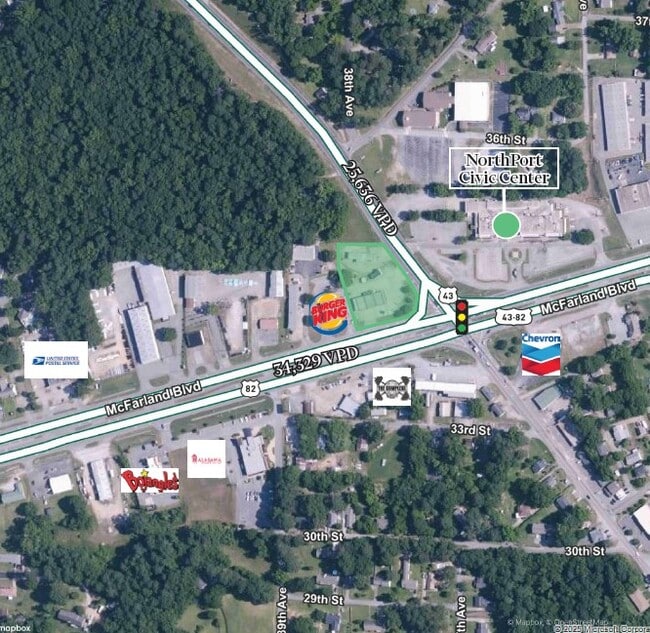
Mcfarland Blvd, , AL
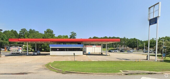


This Property Is For Sale
Property Detail
Mcfarland Blvd
31-02-09-2-006-004.000
LOT 2 BK ADDITION TO NORTHPORT
Conveniencestore
TUSCALOOSA
C-6
Alabama
B and X Area of moderate flood hazard, usually the area between the limits of the 100-year and 500-year floods.
2
2025
0.65 AC
2025
Tuscaloosa
010304
Birmingham
2,160 SF
Tuscaloosa, AL
NEARBY LISTINGS FOR SALE OR LEASE
DEMOGRAPHICS near Mcfarland Blvd
1 mile
3 mile
5 mile
2025 Total Population
5,530
35,787
102,721
2030 Population
5,648
36,261
104,552
Pop Growth 2025-2030
+ 2.13%
+ 1.32%
+ 1.78%
Average Age
43
39
35
2025 Total Households
1,811
14,175
35,971
HH Growth 2025-2030
+ 0.77%
+ 0.84%
+ 1.91%
Median Household Inc
$77,600
$66,807
$51,120
Avg Household Size
2.40
2.20
2.20
2025 Avg HH Vehicles
2.00
2.00
2.00
Median Home Value
$243,381
$263,819
$271,188
Median Year Built
1984
1985
1990
Nearby Places
Map Layers
Map Styles
 Street
 Aerial
Transit
 Traffic
 Biking
Places
Listings with unknown addresses are not visible on the map
- Restaurants
- Banks
- Shops
- Fitness
- Groceries
PUBLIC TRANSPORTATION
COMMUTER RAIL
Tuscaloosa Amtrak Station (Crescent - Amtrak)
Drive
Walk
Distance
Tuscaloosa Amtrak Station (Crescent - Amtrak)
7 min
4.0 mi
Freight Ports
Port of Mobile
Drive
Walk
Distance
Port of Mobile
244 min
202.8 mi
Nearby Properties
Address
Land Use
TOTAL SIZE
Lot Size
Zoning
Address
Land Use
TOTAL SIZE
Lot Size
Zoning
148,656 SF
2.79 AC
BC
Address
Land Use
TOTAL SIZE
Lot Size
Zoning
105,728 SF
4.75 AC
BGO
Address
Land Use
TOTAL SIZE
Lot Size
Zoning
121,384 SF
21 AC
O-I
Address
Land Use
TOTAL SIZE
Lot Size
Zoning
174,000 SF
28.67 AC
R1
Address
Land Use
TOTAL SIZE
Lot Size
Zoning
20,224 SF
19 AC
RM2
Address
Land Use
TOTAL SIZE
Lot Size
Zoning
173,452 SF
2.30 AC
ML
Address
Land Use
TOTAL SIZE
Lot Size
Zoning
1.33 AC
BC
Address
Land Use
TOTAL SIZE
Lot Size
Zoning
110,000 SF
5.80 AC
RD
Address
Land Use
TOTAL SIZE
Lot Size
Zoning
26,576 SF
2.53 AC
RD
Address
Land Use
TOTAL SIZE
Lot Size
Zoning
361,935 SF
133.67 AC
MH
Address
Land Use
TOTAL SIZE
Lot Size
Zoning
12,048 SF
21 AC
RM2
Address
Land Use
TOTAL SIZE
Lot Size
Zoning
301,560 SF
15 AC
ML
Address
Land Use
TOTAL SIZE
Lot Size
Zoning
10,852 SF
46 AC
I
Address
Land Use
TOTAL SIZE
Lot Size
Zoning
73,848 SF
1.73 AC
BGO
Address
Land Use
TOTAL SIZE
Lot Size
Zoning
96,885 SF
2.34 AC
RD
Address
Land Use
TOTAL SIZE
Lot Size
Zoning
10,440 SF
12 AC
Address
Land Use
TOTAL SIZE
Lot Size
Zoning
15.30 AC
Address
Land Use
TOTAL SIZE
Lot Size
Zoning
143,038 SF
36 AC
O-I
Address
Land Use
TOTAL SIZE
Lot Size
Zoning
32,640 SF
9.80 AC
C6
Address
Land Use
TOTAL SIZE
Lot Size
Zoning
75,870 SF
5.50 AC
R1
Address
Land Use
TOTAL SIZE
Lot Size
Zoning
7,752 SF
11 AC
R4
Address
Land Use
TOTAL SIZE
Lot Size
Zoning
91,231 SF
7.71 AC
ML
Address
Land Use
TOTAL SIZE
Lot Size
Zoning
50,652 SF
19.03 AC
ML
Address
Land Use
TOTAL SIZE
Lot Size
Zoning
3,808 SF
10 AC
R4
Address
Land Use
TOTAL SIZE
Lot Size
Zoning
73,904 SF
0.97 AC
BC
Address
Land Use
TOTAL SIZE
Lot Size
Zoning
3,456 SF
13.98 AC
RM2
Address
Land Use
TOTAL SIZE
Lot Size
Zoning
15,060 SF
11 AC
RM2
Address
Land Use
TOTAL SIZE
Lot Size
Zoning
24,684 SF
12 AC
RM2
Address
Land Use
TOTAL SIZE
Lot Size
Zoning
59,039 SF
1.35 AC
RD
Address
Land Use
TOTAL SIZE
Lot Size
Zoning
52,438 SF
1.43 AC
BGO
The World's #1 Commercial Real Estate Marketplace
Connect with us
© 2026 CoStar Group
The information above has been obtained from sources believed reliable. While we do not doubt its accuracy we have not verified it and make no guarantee, warranty or representation about it. It is your responsibility to independently confirm its accuracy and completeness. Any projections, opinions, assumptions, or estimates used are for example only and do not represent the current or future performance of the property. The value of this transaction to you depends on tax and other factors which should be evaluated by your tax, financial, and legal advisors. You and your advisors should conduct a careful, independent investigation of the property to determine to your satisfaction the suitability of the property for your needs.