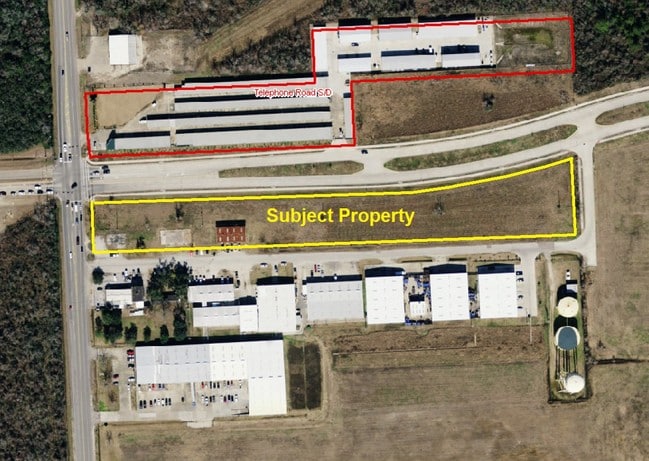
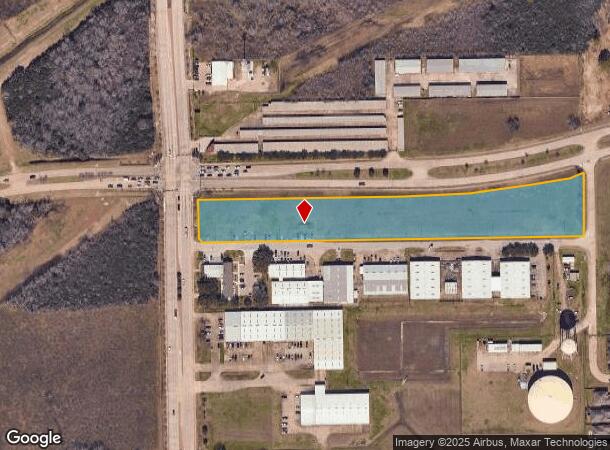
Property Record
3815 Alice St, Pearland, TX 77581
NEARBY LISTINGS FOR SALE OR LEASE
Property Detail
3815 Alice St
Houston-The Woodlands-Sugar Land, TX
H T & B R R
0542-0032-000
A0542 H T & B R R TRACT 52A ACRES 4.8676 (PEARLAND)
Vacantlandnec
Brazoria
X
Texas
48039C0035K
4.87 AC
2024
NASA/Clear Lake
2025
Houston
660401
DEMOGRAPHICS near 3815 Alice St
1 Mile
3 Mile
5 Mile
2024 Total Population
4,855
75,134
200,740
2029 Population
5,347
79,603
211,497
Pop Growth 2024-2029
+ 10.13%
+ 5.95%
+ 5.36%
Average Age
35
36
36
2024 Total Households
1,551
24,126
66,665
HH Growth 2024-2029
+ 10.25%
+ 6.22%
+ 5.48%
Median Household Inc
$120,416
$87,930
$76,776
Avg Household Size
3.00
3.10
2.90
2024 Avg HH Vehicles
2.00
2.00
2.00
Median Home Value
$323,059
$245,654
$240,450
Median Year Built
2002
1999
1993
Nearby Places
- Restaurants
- Banks
- Shops
- Fitness
- Groceries
PUBLIC TRANSPORTATION
AIRPORT
William P Hobby
DRIVE
WALK
Distance
William P Hobby
12 min
4.8 mi
George Bush Intcntl/Houston
DRIVE
WALK
Distance
George Bush Intcntl/Houston
47 min
35.6 mi
Freight Ports
Port of Houston
DRIVE
WALK
Distance
Port of Houston
23 min
13.0 mi
SALE & LEASE HISTORY
LISTING DATE
SALE/LEASE

Sep 24, 2016
For Sale
Nearby Properties
Address
Land Use
TOTAL SIZE
Lot Size
Zoning
Address
Land Use
TOTAL SIZE
Lot Size
Zoning
1,226,700 SF
92.85 AC
Address
Land Use
TOTAL SIZE
Lot Size
Zoning
589,830 SF
47.20 AC
Address
Land Use
TOTAL SIZE
Lot Size
Zoning
359,985 SF
12.56 AC
Address
Land Use
TOTAL SIZE
Lot Size
Zoning
236,642 SF
11.48 AC
Address
Land Use
TOTAL SIZE
Lot Size
Zoning
309,102 SF
16.81 AC
Address
Land Use
TOTAL SIZE
Lot Size
Zoning
128,754 SF
14.83 AC
Address
Land Use
TOTAL SIZE
Lot Size
Zoning
97,736 SF
16.49 AC
Address
Land Use
TOTAL SIZE
Lot Size
Zoning
252,472 SF
13.28 AC
Address
Land Use
TOTAL SIZE
Lot Size
Zoning
72,543 SF
22.64 AC
Address
Land Use
TOTAL SIZE
Lot Size
Zoning
14.93 AC
Address
Land Use
TOTAL SIZE
Lot Size
Zoning
144,879 SF
8.91 AC
Address
Land Use
TOTAL SIZE
Lot Size
Zoning
291,181 SF
11.07 AC
Address
Land Use
TOTAL SIZE
Lot Size
Zoning
285,328 SF
40.75 AC
Address
Land Use
TOTAL SIZE
Lot Size
Zoning
110,990 SF
18.25 AC
Address
Land Use
TOTAL SIZE
Lot Size
Zoning
89.23 AC
Address
Land Use
TOTAL SIZE
Lot Size
Zoning
195,856 SF
20.81 AC
Address
Land Use
TOTAL SIZE
Lot Size
Zoning
155,524 SF
7.86 AC
Address
Land Use
TOTAL SIZE
Lot Size
Zoning
148,902 SF
11.40 AC
Address
Land Use
TOTAL SIZE
Lot Size
Zoning
157,128 SF
10 AC
0041
Address
Land Use
TOTAL SIZE
Lot Size
Zoning
114,828 SF
7.94 AC
Address
Land Use
TOTAL SIZE
Lot Size
Zoning
134,596 SF
7.21 AC
Address
Land Use
TOTAL SIZE
Lot Size
Zoning
67,218 SF
30.11 AC
Address
Land Use
TOTAL SIZE
Lot Size
Zoning
221,377 SF
26.83 AC
Address
Land Use
TOTAL SIZE
Lot Size
Zoning
44,546 SF
7.54 AC
Address
Land Use
TOTAL SIZE
Lot Size
Zoning
67,595 SF
4.97 AC
Address
Land Use
TOTAL SIZE
Lot Size
Zoning
112,800 SF
3.20 AC
Address
Land Use
TOTAL SIZE
Lot Size
Zoning
124,152 SF
9.57 AC
0051
Address
Land Use
TOTAL SIZE
Lot Size
Zoning
99,578 SF
11.63 AC
Address
Land Use
TOTAL SIZE
Lot Size
Zoning
106,341 SF
12.12 AC
0550
Address
Land Use
TOTAL SIZE
Lot Size
Zoning
49.29 AC
0007
The World's #1 Commercial Real Estate Marketplace
Connect with us
© 2025 CoStar Group
The information above has been obtained from sources believed reliable. While we do not doubt its accuracy we have not verified it and make no guarantee, warranty or representation about it. It is your responsibility to independently confirm its accuracy and completeness. Any projections, opinions, assumptions, or estimates used are for example only and do not represent the current or future performance of the property. The value of this transaction to you depends on tax and other factors which should be evaluated by your tax, financial, and legal advisors. You and your advisors should conduct a careful, independent investigation of the property to determine to your satisfaction the suitability of the property for your needs.