Property Record
Mckinnon Rd, Richmond, TX 77406
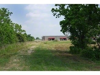

Property Detail
Mckinnon Rd
Houston-Pasadena-The Woodlands, TX
0050 E LATHAM, TRACT 15 (PT), ACRES 25.129
0050-00-000-0152-901
FORT BEND
Ranch
Texas
S
15
B and X Area of moderate flood hazard, usually the area between the limits of the 100-year and 500-year floods.
25.13 AC
2024
Southwest Outlier
2025
Houston
673404
NEARBY LISTINGS FOR SALE OR LEASE
-
-
-
-
-
-
00 NWC OF UNION CHAPEL and Residential-0.88A Blvd
Fulshear, TX 77441
Rent Upon Request
0.88 AC Lots
Land
-
-
-
-
View all Richmond listings for sale on LoopNet.com
DEMOGRAPHICS near Mckinnon Rd
1 mile
3 mile
5 mile
2024 Total Population
1,996
36,049
121,266
2029 Population
2,341
42,185
139,823
Pop Growth 2024-2029
+ 17.28%
+ 17.02%
+ 15.30%
Average Age
38
36
35
2024 Total Households
626
11,073
36,602
HH Growth 2024-2029
+ 17.89%
+ 17.65%
+ 15.94%
Median Household Inc
$179,736
$156,888
$162,097
Avg Household Size
3.20
3.30
3.30
2024 Avg HH Vehicles
2.00
2.00
2.00
Median Home Value
$652,666
$566,458
$528,086
Median Year Built
2011
2011
2011
Nearby Places
Map Layers
Map Styles
 Street
 Aerial
Transit
 Traffic
 Biking
Places
Listings with unknown addresses are not visible on the map
- Restaurants
- Banks
- Shops
- Fitness
- Groceries
SALE & LEASE HISTORY
LISTING DATE
SALE/LEASE

Feb 21, 2020
For Sale
Aug 29, 2019
For Lease
Nearby Properties
Address
Land Use
TOTAL SIZE
Lot Size
Zoning
Address
Land Use
TOTAL SIZE
Lot Size
Zoning
83.43 AC
Address
Land Use
TOTAL SIZE
Lot Size
Zoning
165,097 SF
43.81 AC
Address
Land Use
TOTAL SIZE
Lot Size
Zoning
21.54 AC
Address
Land Use
TOTAL SIZE
Lot Size
Zoning
Address
Land Use
TOTAL SIZE
Lot Size
Zoning
14.80 AC
Address
Land Use
TOTAL SIZE
Lot Size
Zoning
14.88 AC
Address
Land Use
TOTAL SIZE
Lot Size
Zoning
Address
Land Use
TOTAL SIZE
Lot Size
Zoning
Address
Land Use
TOTAL SIZE
Lot Size
Zoning
14.58 AC
Address
Land Use
TOTAL SIZE
Lot Size
Zoning
18,240 SF
66.52 AC
MYN
Address
Land Use
TOTAL SIZE
Lot Size
Zoning
120,000 SF
13.48 AC
Address
Land Use
TOTAL SIZE
Lot Size
Zoning
6,725 SF
23.26 AC
S
Address
Land Use
TOTAL SIZE
Lot Size
Zoning
Address
Land Use
TOTAL SIZE
Lot Size
Zoning
25,956 SF
16.56 AC
S
Address
Land Use
TOTAL SIZE
Lot Size
Zoning
58,037 SF
18.96 AC
QXS
Address
Land Use
TOTAL SIZE
Lot Size
Zoning
3,241 SF
2,198.05 AC
Address
Land Use
TOTAL SIZE
Lot Size
Zoning
5.10 AC
Address
Land Use
TOTAL SIZE
Lot Size
Zoning
6.02 AC
Address
Land Use
TOTAL SIZE
Lot Size
Zoning
3.78 AC
Address
Land Use
TOTAL SIZE
Lot Size
Zoning
7.07 AC
Address
Land Use
TOTAL SIZE
Lot Size
Zoning
6.69 AC
Address
Land Use
TOTAL SIZE
Lot Size
Zoning
15,974 SF
29.79 AC
S
Address
Land Use
TOTAL SIZE
Lot Size
Zoning
86.07 AC
S
Address
Land Use
TOTAL SIZE
Lot Size
Zoning
32,520 SF
2.91 AC
Address
Land Use
TOTAL SIZE
Lot Size
Zoning
88,550 SF
7.53 AC
YNS
Address
Land Use
TOTAL SIZE
Lot Size
Zoning
35,868 SF
2.13 AC
Address
Land Use
TOTAL SIZE
Lot Size
Zoning
9.92 AC
QSY
Address
Land Use
TOTAL SIZE
Lot Size
Zoning
14.01 AC
TS
Address
Land Use
TOTAL SIZE
Lot Size
Zoning
6.40 AC
Address
Land Use
TOTAL SIZE
Lot Size
Zoning
1,105 SF
196.73 AC
QTYS
The World's #1 Commercial Real Estate Marketplace
Connect with us
© 2026 CoStar Group
The information above has been obtained from sources believed reliable. While we do not doubt its accuracy we have not verified it and make no guarantee, warranty or representation about it. It is your responsibility to independently confirm its accuracy and completeness. Any projections, opinions, assumptions, or estimates used are for example only and do not represent the current or future performance of the property. The value of this transaction to you depends on tax and other factors which should be evaluated by your tax, financial, and legal advisors. You and your advisors should conduct a careful, independent investigation of the property to determine to your satisfaction the suitability of the property for your needs.