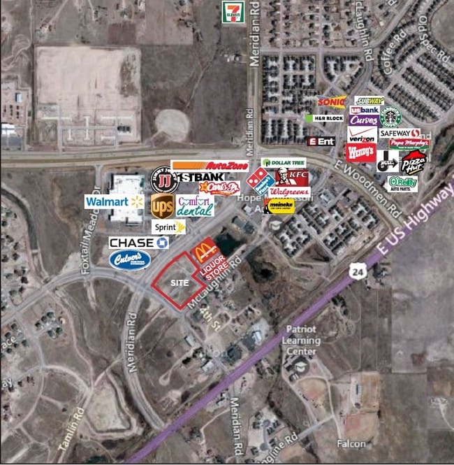
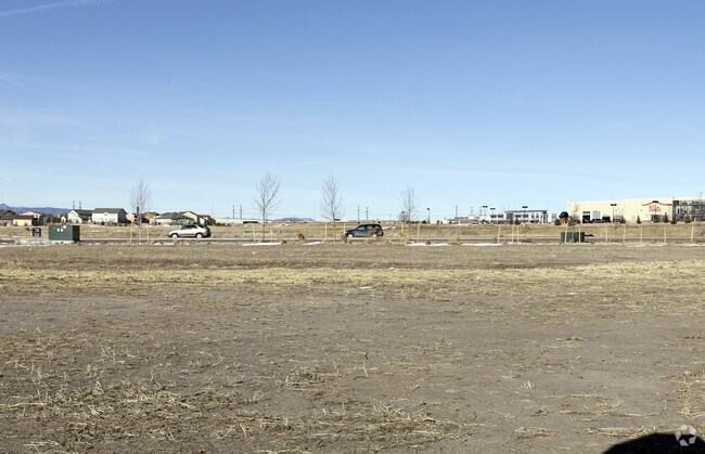
Property Record
Mclaughlin Rd, Peyton, CO 80831

Property Detail
Mclaughlin Rd
Colorado Springs, CO
Town Of Falcon Blk 14 Amended Plat
53121-09-021
3B TOWN OF FALCON BLK 14 AMENDED PLAT EX THAT PT CONV TO R/W BY REC #219148234
Commercialacreage
El Paso
X
Colorado
08041C0561G
1.66 AC
2024
Northeast
2025
Colorado Springs
005122
NEARBY LISTINGS FOR SALE OR LEASE
DEMOGRAPHICS near Mclaughlin Rd
1 mile
3 mile
5 mile
2024 Total Population
4,345
23,163
59,293
2029 Population
4,539
24,442
62,677
Pop Growth 2024-2029
+ 4.46%
+ 5.52%
+ 5.71%
Average Age
36
35
36
2024 Total Households
1,430
7,405
19,188
HH Growth 2024-2029
+ 4.83%
+ 5.78%
+ 5.88%
Median Household Inc
$124,910
$117,665
$117,413
Avg Household Size
3.00
3.10
3.10
2024 Avg HH Vehicles
3.00
3.00
2.00
Median Home Value
$435,851
$437,249
$450,610
Median Year Built
2005
2008
2010
Nearby Places
Map Layers
Map Styles
 Street
 Aerial
Transit
 Traffic
 Biking
Places
Listings with unknown addresses are not visible on the map
- Restaurants
- Banks
- Shops
- Fitness
- Groceries
PUBLIC TRANSPORTATION
AIRPORT
City of Colorado Springs Municipal
Drive
Walk
Distance
City of Colorado Springs Municipal
22 min
11.0 mi
Freight Ports
Tulsa Port Of Catoosa
Drive
Walk
Distance
Tulsa Port Of Catoosa
719 min
679.5 mi
SALE & LEASE HISTORY
LISTING DATE
SALE/LEASE

Mar 20, 2023
For Sale
Apr 05, 2017
For Sale
Nearby Properties
Address
Land Use
TOTAL SIZE
Lot Size
Zoning
Address
Land Use
TOTAL SIZE
Lot Size
Zoning
80,503 SF
14.36 AC
PDZ AO
Address
Land Use
TOTAL SIZE
Lot Size
Zoning
39,446 SF
10.71 AC
RR-5
Address
Land Use
TOTAL SIZE
Lot Size
Zoning
123,673 SF
9.98 AC
CR
Address
Land Use
TOTAL SIZE
Lot Size
Zoning
195,448 SF
19.86 AC
CR
Address
Land Use
TOTAL SIZE
Lot Size
Zoning
46,935 SF
13.62 AC
PUD
Address
Land Use
TOTAL SIZE
Lot Size
Zoning
16,915 SF
5.19 AC
PUD
Address
Land Use
TOTAL SIZE
Lot Size
Zoning
7,573 SF
757.70 AC
PUD R-4 R-
Address
Land Use
TOTAL SIZE
Lot Size
Zoning
16,455 SF
6.89 AC
A-35 RR-2.
Address
Land Use
TOTAL SIZE
Lot Size
Zoning
15,406 SF
5.42 AC
RR-5
Address
Land Use
TOTAL SIZE
Lot Size
Zoning
10,017 SF
1.50 AC
CR
Address
Land Use
TOTAL SIZE
Lot Size
Zoning
13,048 SF
1.63 AC
CR
Address
Land Use
TOTAL SIZE
Lot Size
Zoning
3,148 SF
0.58 AC
CR
Address
Land Use
TOTAL SIZE
Lot Size
Zoning
38,804 SF
39.37 AC
RR-5
Address
Land Use
TOTAL SIZE
Lot Size
Zoning
41,592 SF
8.59 AC
RR-5
Address
Land Use
TOTAL SIZE
Lot Size
Zoning
6,289 SF
2.04 AC
CC
Address
Land Use
TOTAL SIZE
Lot Size
Zoning
299 SF
6.19 AC
PK AO SS
Address
Land Use
TOTAL SIZE
Lot Size
Zoning
5,970 SF
35.54 AC
RR-2.5
Address
Land Use
TOTAL SIZE
Lot Size
Zoning
12,111 SF
2.54 AC
PUD
Address
Land Use
TOTAL SIZE
Lot Size
Zoning
29,113 SF
3.43 AC
CR
Address
Land Use
TOTAL SIZE
Lot Size
Zoning
8,788 SF
35.90 AC
RR-5
Address
Land Use
TOTAL SIZE
Lot Size
Zoning
8,134 SF
10.19 AC
I-2
Address
Land Use
TOTAL SIZE
Lot Size
Zoning
14,014 SF
9.90 AC
PDZ AO
Address
Land Use
TOTAL SIZE
Lot Size
Zoning
26,235 SF
2.93 AC
CR
Address
Land Use
TOTAL SIZE
Lot Size
Zoning
85,148 SF
8.12 AC
I-2
Address
Land Use
TOTAL SIZE
Lot Size
Zoning
4,957 SF
1.77 AC
CR RS-2000
Address
Land Use
TOTAL SIZE
Lot Size
Zoning
9,901 SF
2.49 AC
CR
Address
Land Use
TOTAL SIZE
Lot Size
Zoning
22,680 SF
2.84 AC
CR
Address
Land Use
TOTAL SIZE
Lot Size
Zoning
13,954 SF
4.78 AC
RR-5
Address
Land Use
TOTAL SIZE
Lot Size
Zoning
55,980 SF
5.95 AC
CR
Address
Land Use
TOTAL SIZE
Lot Size
Zoning
160 AC
RR-5
The World's #1 Commercial Real Estate Marketplace
Connect with us
© 2026 CoStar Group
The information above has been obtained from sources believed reliable. While we do not doubt its accuracy we have not verified it and make no guarantee, warranty or representation about it. It is your responsibility to independently confirm its accuracy and completeness. Any projections, opinions, assumptions, or estimates used are for example only and do not represent the current or future performance of the property. The value of this transaction to you depends on tax and other factors which should be evaluated by your tax, financial, and legal advisors. You and your advisors should conduct a careful, independent investigation of the property to determine to your satisfaction the suitability of the property for your needs.