Property Record
Meadow Trak, Atlantic City, NJ 08401

Save to a Folder
{{folder.Name}}
{{folder.ListingIds.length}} Properties
{{folder.ListingIds.length}} Property
Create a New Folder
Property Detail
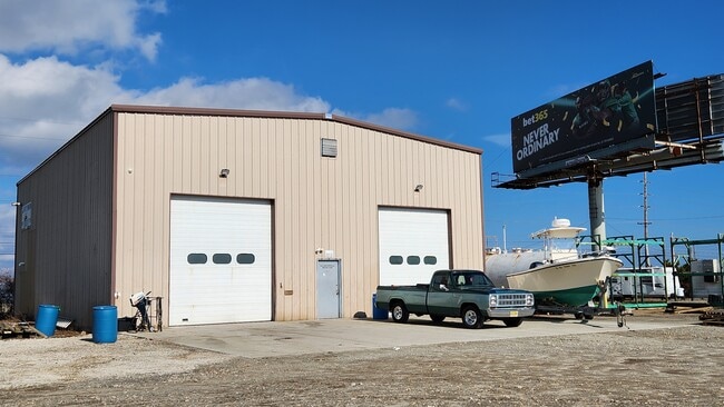
Meadow Trak
02-00799-0000-00016
ATLANTIC
Commercialnec
New Jersey
MTM
16
2025
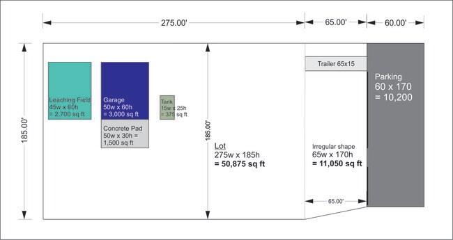
4.44 AC
2026
Atlantic City/Hammonton
002300
Philadelphia
924 SF
Atlantic City-Hammonton, NJ
NEARBY LISTINGS FOR SALE OR LEASE
DEMOGRAPHICS near Meadow Trak
1 mile
3 mile
5 mile
2025 Total Population
0
51,868
109,990
2030 Population
0
52,872
113,674
Pop Growth 2025-2030
0.00%
+ 1.94%
+ 3.35%
Average Age
0
39
43
2025 Total Households
0
20,063
45,168
HH Growth 2025-2030
0.00%
+ 1.91%
+ 3.65%
Median Household Inc
$0
$50,495
$62,212
Avg Household Size
.00
2.40
2.30
2025 Avg HH Vehicles
.00
1.00
1.00
Median Home Value
$0
$223,469
$322,293
Median Year Built
0
1960
1965
Nearby Places
Map Layers
Map Styles
 Street
 Aerial
Layers
 Traffic
 Biking
Places
Listings with unknown addresses are not visible on the map
- Restaurants
- Banks
- Shops
- Fitness
- Groceries
PUBLIC TRANSPORTATION
COMMUTER RAIL
Atlantic City (Atlantic City Line - NJ Transit Commuter Rail (NJ Transit))
Drive
Walk
Distance
Atlantic City (Atlantic City Line - NJ Transit Commuter Rail (NJ Transit))
8 min
3.2 mi
Absecon (Atlantic City Line - NJ Transit Commuter Rail (NJ Transit))
Drive
Walk
Distance
Absecon (Atlantic City Line - NJ Transit Commuter Rail (NJ Transit))
10 min
5.6 mi
AIRPORT
Atlantic City International
Drive
Walk
Distance
Atlantic City International
39 min
14.0 mi
SALE & LEASE HISTORY
LISTING DATE
SALE/LEASE

Jun 12, 2025
For Lease
Feb 12, 2024
For Lease
Nearby Properties
Address
Land Use
TOTAL SIZE
Lot Size
Zoning
Address
Land Use
TOTAL SIZE
Lot Size
Zoning
25.97 AC
HNRA
Address
Land Use
TOTAL SIZE
Lot Size
Zoning
1.51 AC
RS-C
Address
Land Use
TOTAL SIZE
Lot Size
Zoning
2,497,916 SF
6.96 AC
CBD
Address
Land Use
TOTAL SIZE
Lot Size
Zoning
6.20 AC
RS-C
Address
Land Use
TOTAL SIZE
Lot Size
Zoning
11.04 AC
HNRA
Address
Land Use
TOTAL SIZE
Lot Size
Zoning
5,364 SF
142.55 AC
BFRA
Address
Land Use
TOTAL SIZE
Lot Size
Zoning
14.71 AC
RS-C
Address
Land Use
TOTAL SIZE
Lot Size
Zoning
69.16 AC
HNRA
Address
Land Use
TOTAL SIZE
Lot Size
Zoning
398,702 SF
4.05 AC
RS-C
Address
Land Use
TOTAL SIZE
Lot Size
Zoning
6,552 SF
3.61 AC
RS
Address
Land Use
TOTAL SIZE
Lot Size
Zoning
3.54 AC
HNRA
Address
Land Use
TOTAL SIZE
Lot Size
Zoning
387,249 SF
49.56 AC
HW-C
Address
Land Use
TOTAL SIZE
Lot Size
Zoning
0.22 AC
RS-C
Address
Land Use
TOTAL SIZE
Lot Size
Zoning
4.33 AC
RS-C
Address
Land Use
TOTAL SIZE
Lot Size
Zoning
Address
Land Use
TOTAL SIZE
Lot Size
Zoning
1.98 AC
RS-C
Address
Land Use
TOTAL SIZE
Lot Size
Zoning
0.78 AC
RS-C
Address
Land Use
TOTAL SIZE
Lot Size
Zoning
2.44 AC
RS-C
Address
Land Use
TOTAL SIZE
Lot Size
Zoning
3.01 AC
RS-C
Address
Land Use
TOTAL SIZE
Lot Size
Zoning
2.81 AC
RS-C
Address
Land Use
TOTAL SIZE
Lot Size
Zoning
192,602 SF
5.80 AC
RS-C
Address
Land Use
TOTAL SIZE
Lot Size
Zoning
277,716 SF
5.45 AC
RS-C
Address
Land Use
TOTAL SIZE
Lot Size
Zoning
26,624 SF
47.40 AC
M-C
Address
Land Use
TOTAL SIZE
Lot Size
Zoning
1.66 AC
RS-C
Address
Land Use
TOTAL SIZE
Lot Size
Zoning
2.75 AC
Address
Land Use
TOTAL SIZE
Lot Size
Zoning
2.91 AC
RS-C
Address
Land Use
TOTAL SIZE
Lot Size
Zoning
43,980 SF
1.80 AC
R-3
Address
Land Use
TOTAL SIZE
Lot Size
Zoning
8.35 AC
HNRA
Address
Land Use
TOTAL SIZE
Lot Size
Zoning
4.22 AC
RS-C
Address
Land Use
TOTAL SIZE
Lot Size
Zoning
1.66 AC
RS-C
The World's #1 Commercial Real Estate Marketplace
Connect with us
© 2026 CoStar Group
The information above has been obtained from sources believed reliable. While we do not doubt its accuracy we have not verified it and make no guarantee, warranty or representation about it. It is your responsibility to independently confirm its accuracy and completeness. Any projections, opinions, assumptions, or estimates used are for example only and do not represent the current or future performance of the property. The value of this transaction to you depends on tax and other factors which should be evaluated by your tax, financial, and legal advisors. You and your advisors should conduct a careful, independent investigation of the property to determine to your satisfaction the suitability of the property for your needs.