Property Record
Mellen St, Centralia, WA 98531
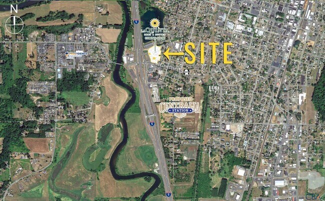
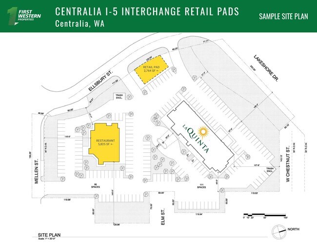
Property Detail
Mellen St
Centralia, WA
SECTION 07 TOWNSHIP 14N RANGE 02W LT C BLA 3504899
002249-000-000
LEWIS
Commercialnec
Washington
C1
c
2024
1.12 AC
2025
Washington State Area
970500
Other Market Areas
NEARBY LISTINGS FOR SALE OR LEASE
DEMOGRAPHICS near Mellen St
1 mile
3 mile
5 mile
2025 Total Population
7,275
24,821
36,291
2030 Population
7,504
25,683
37,529
Pop Growth 2025-2030
+ 3.15%
+ 3.47%
+ 3.41%
Average Age
38
40
40
2025 Total Households
2,748
9,526
13,850
HH Growth 2025-2030
+ 3.09%
+ 3.44%
+ 3.37%
Median Household Inc
$59,725
$60,371
$65,670
Avg Household Size
2.50
2.50
2.50
2025 Avg HH Vehicles
2.00
2.00
2.00
Median Home Value
$356,235
$345,849
$360,734
Median Year Built
1962
1977
1976
Nearby Places
Map Layers
Map Styles
 Street
 Aerial
Transit
 Traffic
 Biking
Places
Listings with unknown addresses are not visible on the map
- Restaurants
- Banks
- Shops
- Fitness
- Groceries
PUBLIC TRANSPORTATION
COMMUTER RAIL
Drive
Walk
Distance
5 min
1.5 mi
Freight Ports
Port of Long View, WA
Drive
Walk
Distance
Port of Long View, WA
59 min
46.0 mi
SALE & LEASE HISTORY
LISTING DATE
SALE/LEASE

Nov 03, 2016
For Sale
Nearby Properties
Address
Land Use
TOTAL SIZE
Lot Size
Zoning
Address
Land Use
TOTAL SIZE
Lot Size
Zoning
1,038,447 SF
77 AC
PMP
Address
Land Use
TOTAL SIZE
Lot Size
Zoning
2,003 SF
27.85 AC
LBD
Address
Land Use
TOTAL SIZE
Lot Size
Zoning
129,242 SF
11.91 AC
M1
Address
Land Use
TOTAL SIZE
Lot Size
Zoning
Address
Land Use
TOTAL SIZE
Lot Size
Zoning
1,792 SF
38.78 AC
OSPF
Address
Land Use
TOTAL SIZE
Lot Size
Zoning
1,714 SF
220.30 AC
EPFA
Address
Land Use
TOTAL SIZE
Lot Size
Zoning
142,368 SF
6.60 AC
R20
Address
Land Use
TOTAL SIZE
Lot Size
Zoning
2,956 SF
4.99 AC
R15
Address
Land Use
TOTAL SIZE
Lot Size
Zoning
64,421 SF
5 AC
H1
Address
Land Use
TOTAL SIZE
Lot Size
Zoning
7,168 SF
4.10 AC
OSPF
Address
Land Use
TOTAL SIZE
Lot Size
Zoning
43,477 SF
8.64 AC
CG
Address
Land Use
TOTAL SIZE
Lot Size
Zoning
57,621 SF
5.33 AC
H1
Address
Land Use
TOTAL SIZE
Lot Size
Zoning
2.14 AC
C1
Address
Land Use
TOTAL SIZE
Lot Size
Zoning
7,200 SF
4 AC
OSPF
Address
Land Use
TOTAL SIZE
Lot Size
Zoning
28,522 SF
2 AC
M2
Address
Land Use
TOTAL SIZE
Lot Size
Zoning
29,204 SF
3.91 AC
R20
Address
Land Use
TOTAL SIZE
Lot Size
Zoning
34,150 SF
7.20 AC
CG
Address
Land Use
TOTAL SIZE
Lot Size
Zoning
Address
Land Use
TOTAL SIZE
Lot Size
Zoning
Address
Land Use
TOTAL SIZE
Lot Size
Zoning
Address
Land Use
TOTAL SIZE
Lot Size
Zoning
3,196 SF
4.48 AC
R15
Address
Land Use
TOTAL SIZE
Lot Size
Zoning
48,865 SF
4.70 AC
H1
Address
Land Use
TOTAL SIZE
Lot Size
Zoning
104,872 SF
Address
Land Use
TOTAL SIZE
Lot Size
Zoning
94,044 SF
Address
Land Use
TOTAL SIZE
Lot Size
Zoning
Address
Land Use
TOTAL SIZE
Lot Size
Zoning
13.11 AC
Address
Land Use
TOTAL SIZE
Lot Size
Zoning
3,536 SF
1.73 AC
R20
Address
Land Use
TOTAL SIZE
Lot Size
Zoning
83,043 SF
6.76 AC
CG
Address
Land Use
TOTAL SIZE
Lot Size
Zoning
1,512 SF
8.64 AC
OSPF
Address
Land Use
TOTAL SIZE
Lot Size
Zoning
21,672 SF
2.08 AC
R20
The World's #1 Commercial Real Estate Marketplace
Connect with us
© 2026 CoStar Group
The information above has been obtained from sources believed reliable. While we do not doubt its accuracy we have not verified it and make no guarantee, warranty or representation about it. It is your responsibility to independently confirm its accuracy and completeness. Any projections, opinions, assumptions, or estimates used are for example only and do not represent the current or future performance of the property. The value of this transaction to you depends on tax and other factors which should be evaluated by your tax, financial, and legal advisors. You and your advisors should conduct a careful, independent investigation of the property to determine to your satisfaction the suitability of the property for your needs.