Property Record
Memorial Rd, Jones, OK 73049
Save to a Folder
{{folder.Name}}
{{folder.ListingIds.length}} Properties
{{folder.ListingIds.length}} Property
Create a New Folder
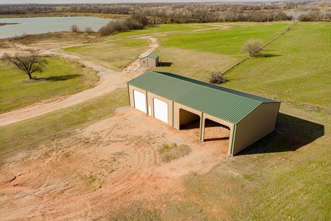
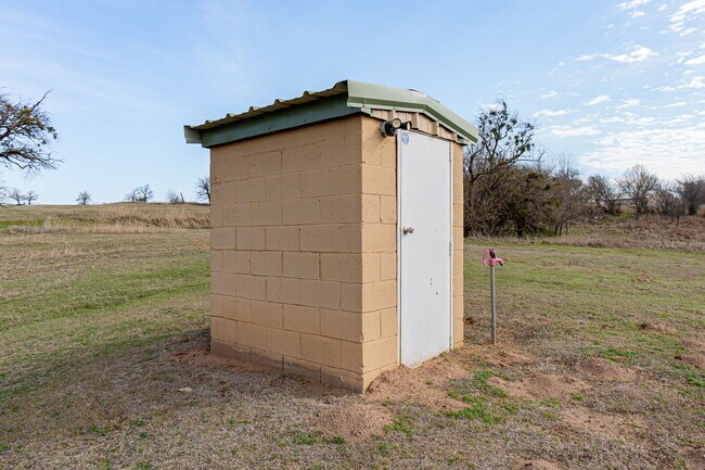
This Property Is For Sale
Property Detail
Memorial Rd
Oklahoma City, OK
SPRINGER TOWNSHIP 000 000 PT OF NE4 SEC 17 13N 1W BEG 1387.04FT S OF NE/C NE4 TH S246.76FT W1657FT N313.80FT E399.97FT S67.04FT E1257.03FT TO BEG CONT 10ACRS MORE OR LESS PLUS BEG 1633.80FT S OF NE/C NE4 TH S50FT W387FT SW70.71FT W869.72FT S289.20FT
193891020
OKLAHOMA
Agriculturalland
Oklahoma
AA
3
AE The base floodplain where base flood elevations are provided. AE Zones are now used on new format FIRMs instead of A1-A30 Zones.
160 AC
2025
East Oklahoma County
2025
Oklahoma City
108900
NEARBY LISTINGS FOR SALE OR LEASE
-
-
View all Jones listings for sale on LoopNet.com
DEMOGRAPHICS near Memorial Rd
1 mile
3 mile
5 mile
2025 Total Population
287
3,129
10,496
2030 Population
298
3,263
10,898
Pop Growth 2025-2030
+ 3.83%
+ 4.28%
+ 3.83%
Average Age
41
42
41
2025 Total Households
106
1,156
3,821
HH Growth 2025-2030
+ 3.77%
+ 4.41%
+ 4.03%
Median Household Inc
$78,750
$95,668
$100,561
Avg Household Size
2.60
2.60
2.70
2025 Avg HH Vehicles
3.00
3.00
2.00
Median Home Value
$387,499
$468,799
$445,687
Median Year Built
1993
1995
1994
Nearby Places
Map Layers
Map Styles
 Street
 Aerial
Layers
 Traffic
 Biking
Places
Listings with unknown addresses are not visible on the map
- Restaurants
- Banks
- Shops
- Fitness
- Groceries
PUBLIC TRANSPORTATION
AIRPORT
Will Rogers World
Drive
Walk
Distance
Will Rogers World
44 min
29.3 mi
Freight Ports
Tulsa Port Of Catoosa
Drive
Walk
Distance
Tulsa Port Of Catoosa
123 min
107.0 mi
Nearby Properties
Address
Land Use
TOTAL SIZE
Lot Size
Zoning
Address
Land Use
TOTAL SIZE
Lot Size
Zoning
9,472 SF
9.24 AC
Address
Land Use
TOTAL SIZE
Lot Size
Zoning
425 SF
56.36 AC
AA
Address
Land Use
TOTAL SIZE
Lot Size
Zoning
36,360 SF
3.47 AC
Address
Land Use
TOTAL SIZE
Lot Size
Zoning
9,840 SF
0.28 AC
Address
Land Use
TOTAL SIZE
Lot Size
Zoning
49 AC
AA
Address
Land Use
TOTAL SIZE
Lot Size
Zoning
32,500 SF
2.01 AC
Address
Land Use
TOTAL SIZE
Lot Size
Zoning
12,661 SF
1.52 AC
Address
Land Use
TOTAL SIZE
Lot Size
Zoning
15,408 SF
5 AC
Address
Land Use
TOTAL SIZE
Lot Size
Zoning
32,774 SF
2.98 AC
Address
Land Use
TOTAL SIZE
Lot Size
Zoning
5,741 SF
2.12 AC
Address
Land Use
TOTAL SIZE
Lot Size
Zoning
24,410 SF
1.42 AC
Address
Land Use
TOTAL SIZE
Lot Size
Zoning
1,291 SF
5.01 AC
AA
Address
Land Use
TOTAL SIZE
Lot Size
Zoning
8,775 SF
1 AC
Address
Land Use
TOTAL SIZE
Lot Size
Zoning
8,320 SF
1.34 AC
Address
Land Use
TOTAL SIZE
Lot Size
Zoning
14,076 SF
4 AC
Address
Land Use
TOTAL SIZE
Lot Size
Zoning
4,880 SF
1.50 AC
Address
Land Use
TOTAL SIZE
Lot Size
Zoning
93.22 AC
AA
Address
Land Use
TOTAL SIZE
Lot Size
Zoning
8,458 SF
5 AC
AA
Address
Land Use
TOTAL SIZE
Lot Size
Zoning
21,500 SF
3 AC
Address
Land Use
TOTAL SIZE
Lot Size
Zoning
16,000 SF
1.66 AC
Address
Land Use
TOTAL SIZE
Lot Size
Zoning
5,802 SF
AA
Address
Land Use
TOTAL SIZE
Lot Size
Zoning
8,190 SF
0.94 AC
Address
Land Use
TOTAL SIZE
Lot Size
Zoning
10.06 AC
Address
Land Use
TOTAL SIZE
Lot Size
Zoning
2,800 SF
0.34 AC
Address
Land Use
TOTAL SIZE
Lot Size
Zoning
10 AC
AA
Address
Land Use
TOTAL SIZE
Lot Size
Zoning
1,200 SF
3.48 AC
Address
Land Use
TOTAL SIZE
Lot Size
Zoning
9,000 SF
0.62 AC
Address
Land Use
TOTAL SIZE
Lot Size
Zoning
5.05 AC
AA
Address
Land Use
TOTAL SIZE
Lot Size
Zoning
2,048 SF
20.51 AC
R-1
The World's #1 Commercial Real Estate Marketplace
Connect with us
© 2026 CoStar Group
The information above has been obtained from sources believed reliable. While we do not doubt its accuracy we have not verified it and make no guarantee, warranty or representation about it. It is your responsibility to independently confirm its accuracy and completeness. Any projections, opinions, assumptions, or estimates used are for example only and do not represent the current or future performance of the property. The value of this transaction to you depends on tax and other factors which should be evaluated by your tax, financial, and legal advisors. You and your advisors should conduct a careful, independent investigation of the property to determine to your satisfaction the suitability of the property for your needs.