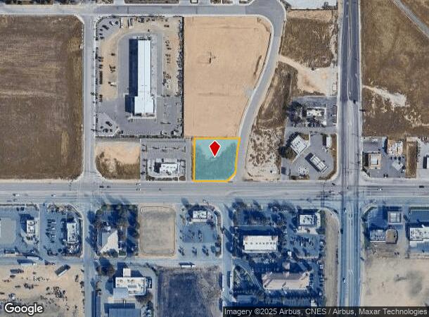
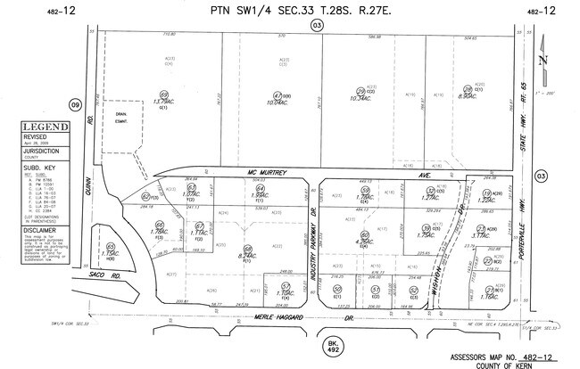
Property Record
Merle Haggard Dr, Kern County, CA 93308
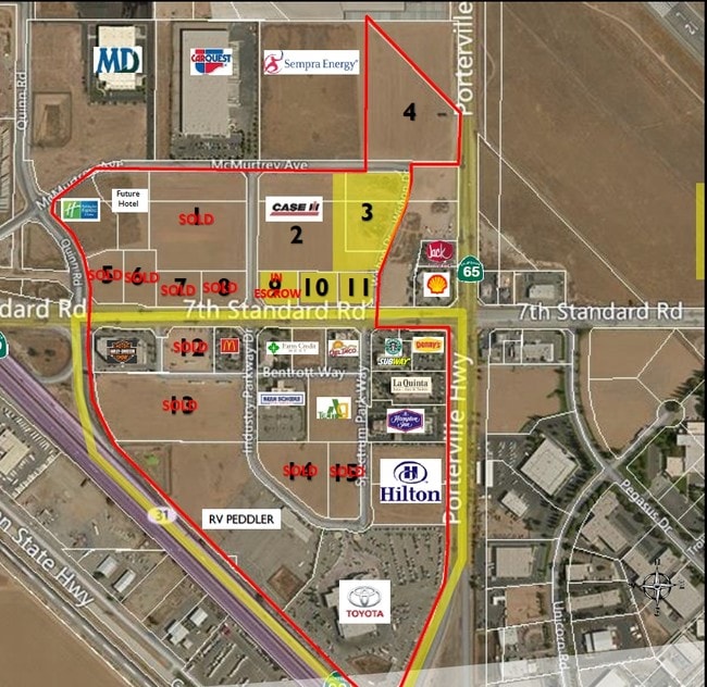
NEARBY LISTINGS FOR SALE OR LEASE
-
-
-
-
-
No Photo
-
-
View all Kern County listings for lease on LoopNet.com
Property Detail
Merle Haggard Dr
Bakersfield, CA
SECTION 33 , TOWNSHIP 28 , RANGE 27 , QUARTER
482-120-52-00-0
Kern
Industrialacreage
California
X
3
06029C1825F
0.92 AC
2024
North Bakersfield
2025
Bakersfield
003900
DEMOGRAPHICS near Merle Haggard Dr
1 Mile
3 Mile
5 Mile
2024 Total Population
0
43,209
110,414
2029 Population
0
43,188
110,402
Pop Growth 2024-2029
0.00%
(0.05%)
(0.01%)
Average Age
0
37
36
2024 Total Households
0
14,988
37,868
HH Growth 2024-2029
0.00%
(0.09%)
(0.04%)
Median Household Inc
$0
$75,058
$70,729
Avg Household Size
.00
2.80
2.90
2024 Avg HH Vehicles
.00
2.00
2.00
Median Home Value
$0
$346,381
$328,171
Median Year Built
0
1992
1991
Nearby Places
- Restaurants
- Banks
- Shops
- Fitness
- Groceries
PUBLIC TRANSPORTATION
COMMUTER RAIL
Bakersfield (San Joaquins - Amtrak)
DRIVE
WALK
Distance
Bakersfield (San Joaquins - Amtrak)
10 min
7.1 mi
AIRPORT
Meadows Field
DRIVE
WALK
Distance
Meadows Field
9 min
2.4 mi
Freight Ports
The Port of Hueneme
DRIVE
WALK
Distance
The Port of Hueneme
158 min
127.5 mi
SALE & LEASE HISTORY
LISTING DATE
SALE/LEASE

Sep 25, 2016
For Lease
Sep 24, 2016
For Sale
Dec 13, 2018
For Lease
Apr 20, 2017
For Sale
Nearby Properties
Address
Land Use
TOTAL SIZE
Lot Size
Zoning
Address
Land Use
TOTAL SIZE
Lot Size
Zoning
2,645,250 SF
64.24 AC
M-2 PD H
Address
Land Use
TOTAL SIZE
Lot Size
Zoning
30,326 SF
19 AC
M3
Address
Land Use
TOTAL SIZE
Lot Size
Zoning
10,064 SF
13.44 AC
R3
Address
Land Use
TOTAL SIZE
Lot Size
Zoning
63,428 SF
5.18 AC
C-2
Address
Land Use
TOTAL SIZE
Lot Size
Zoning
41,394 SF
14.74 AC
Address
Land Use
TOTAL SIZE
Lot Size
Zoning
134,728 SF
7.56 AC
R3
Address
Land Use
TOTAL SIZE
Lot Size
Zoning
Address
Land Use
TOTAL SIZE
Lot Size
Zoning
2,129 SF
11.42 AC
M-2
Address
Land Use
TOTAL SIZE
Lot Size
Zoning
3,497 SF
31.27 AC
E
Address
Land Use
TOTAL SIZE
Lot Size
Zoning
151,797 SF
4.42 AC
R3
Address
Land Use
TOTAL SIZE
Lot Size
Zoning
3,383 SF
19.40 AC
M-2
Address
Land Use
TOTAL SIZE
Lot Size
Zoning
72,726 SF
13.15 AC
M2
Address
Land Use
TOTAL SIZE
Lot Size
Zoning
50,949 SF
78.05 AC
M-2
Address
Land Use
TOTAL SIZE
Lot Size
Zoning
54,960 SF
15.83 AC
M-2
Address
Land Use
TOTAL SIZE
Lot Size
Zoning
168,559 SF
5.34 AC
M-2
Address
Land Use
TOTAL SIZE
Lot Size
Zoning
55,215 SF
3.93 AC
C-2
Address
Land Use
TOTAL SIZE
Lot Size
Zoning
12,000 SF
11.90 AC
M-2 PD
Address
Land Use
TOTAL SIZE
Lot Size
Zoning
357,609 SF
21.80 AC
M2
Address
Land Use
TOTAL SIZE
Lot Size
Zoning
226,463 SF
11.01 AC
R3
Address
Land Use
TOTAL SIZE
Lot Size
Zoning
2,542 SF
5 AC
M1
Address
Land Use
TOTAL SIZE
Lot Size
Zoning
57,560 SF
5.53 AC
C1
Address
Land Use
TOTAL SIZE
Lot Size
Zoning
56,750 SF
5.27 AC
C2
Address
Land Use
TOTAL SIZE
Lot Size
Zoning
7,196 SF
2.24 AC
Address
Land Use
TOTAL SIZE
Lot Size
Zoning
184,680 SF
10.97 AC
R-2
Address
Land Use
TOTAL SIZE
Lot Size
Zoning
62,536 SF
2.11 AC
M2
Address
Land Use
TOTAL SIZE
Lot Size
Zoning
55,042 SF
0.49 AC
M1
Address
Land Use
TOTAL SIZE
Lot Size
Zoning
2,740 SF
7.08 AC
M-2
Address
Land Use
TOTAL SIZE
Lot Size
Zoning
22,572 SF
44.92 AC
M-2 PD
Address
Land Use
TOTAL SIZE
Lot Size
Zoning
132,096 SF
8.93 AC
C-2
The World's #1 Commercial Real Estate Marketplace
Connect with us
© 2025 CoStar Group
The information above has been obtained from sources believed reliable. While we do not doubt its accuracy we have not verified it and make no guarantee, warranty or representation about it. It is your responsibility to independently confirm its accuracy and completeness. Any projections, opinions, assumptions, or estimates used are for example only and do not represent the current or future performance of the property. The value of this transaction to you depends on tax and other factors which should be evaluated by your tax, financial, and legal advisors. You and your advisors should conduct a careful, independent investigation of the property to determine to your satisfaction the suitability of the property for your needs.