No Photo
Property Record
Merrick Rd, Hamilton, NJ 08691

Save to a Folder
{{folder.Name}}
{{folder.ListingIds.length}} Properties
{{folder.ListingIds.length}} Property
Create a New Folder
Property Detail
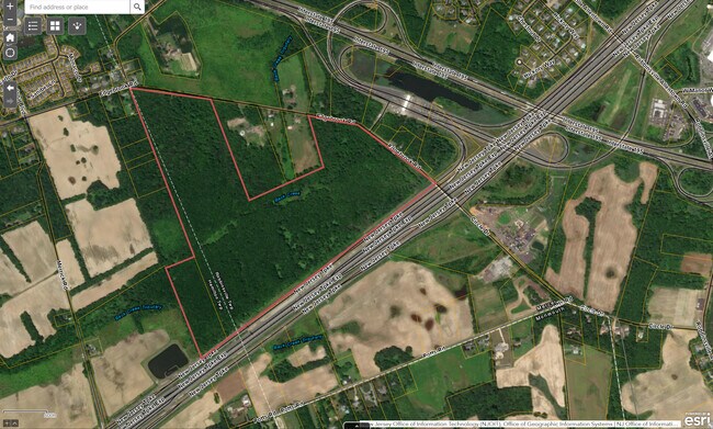
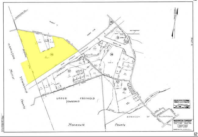
Merrick Rd
Trenton-Princeton, NJ
12829-
03-02715-0000-00011
MERCER
Farms
New Jersey
RRC
11
A Areas with a 1% annual chance of flooding and a 26% chance of flooding over the life of a 30-year mortgage.
10.80 AC
2025
Trenton
2026
Northern New Jersey
004309
NEARBY LISTINGS FOR SALE OR LEASE
-
-
-
-
-
-
-
No Photo
-
View all Hamilton listings for sale on LoopNet.com
DEMOGRAPHICS near Merrick Rd
1 mile
3 mile
5 mile
2025 Total Population
1,619
25,016
79,981
2030 Population
1,672
25,753
82,190
Pop Growth 2025-2030
+ 3.27%
+ 2.95%
+ 2.76%
Average Age
47
43
43
2025 Total Households
557
9,333
30,076
HH Growth 2025-2030
+ 3.05%
+ 3.04%
+ 2.91%
Median Household Inc
$186,874
$131,021
$116,460
Avg Household Size
2.80
2.70
2.50
2025 Avg HH Vehicles
3.00
2.00
2.00
Median Home Value
$683,046
$499,645
$410,258
Median Year Built
1996
1987
1977
Nearby Places
Map Layers
Map Styles
 Street
 Aerial
Layers
 Traffic
 Biking
Places
Listings with unknown addresses are not visible on the map
- Restaurants
- Banks
- Shops
- Fitness
- Groceries
PUBLIC TRANSPORTATION
AIRPORT
Trenton Mercer
Drive
Walk
Distance
Trenton Mercer
34 min
21.6 mi
Freight Ports
Port of Philadelphia
Drive
Walk
Distance
Port of Philadelphia
44 min
34.0 mi
SALE & LEASE HISTORY
LISTING DATE
SALE/LEASE

Oct 12, 2020
For Sale
Nearby Properties
Address
Land Use
TOTAL SIZE
Lot Size
Zoning
Address
Land Use
TOTAL SIZE
Lot Size
Zoning
31.05 AC
Address
Land Use
TOTAL SIZE
Lot Size
Zoning
23.13 AC
RD
Address
Land Use
TOTAL SIZE
Lot Size
Zoning
55.71 AC
PCD
Address
Land Use
TOTAL SIZE
Lot Size
Zoning
64.43 AC
PCD
Address
Land Use
TOTAL SIZE
Lot Size
Zoning
30.94 AC
Address
Land Use
TOTAL SIZE
Lot Size
Zoning
60.26 AC
RD
Address
Land Use
TOTAL SIZE
Lot Size
Zoning
65.18 AC
PCD
Address
Land Use
TOTAL SIZE
Lot Size
Zoning
585,222 SF
44.82 AC
RD
Address
Land Use
TOTAL SIZE
Lot Size
Zoning
392,050 SF
45.57 AC
Address
Land Use
TOTAL SIZE
Lot Size
Zoning
Address
Land Use
TOTAL SIZE
Lot Size
Zoning
47.91 AC
PCD
Address
Land Use
TOTAL SIZE
Lot Size
Zoning
79.71 AC
PCD
Address
Land Use
TOTAL SIZE
Lot Size
Zoning
60.18 AC
PCD
Address
Land Use
TOTAL SIZE
Lot Size
Zoning
266,000 SF
56.90 AC
RD
Address
Land Use
TOTAL SIZE
Lot Size
Zoning
37.90 AC
PCD
Address
Land Use
TOTAL SIZE
Lot Size
Zoning
134,000 SF
117.90 AC
AR
Address
Land Use
TOTAL SIZE
Lot Size
Zoning
64,184 SF
8.53 AC
MF0
Address
Land Use
TOTAL SIZE
Lot Size
Zoning
104.44 AC
PCD
Address
Land Use
TOTAL SIZE
Lot Size
Zoning
339,339 SF
33.91 AC
RD
Address
Land Use
TOTAL SIZE
Lot Size
Zoning
9.63 AC
RD
Address
Land Use
TOTAL SIZE
Lot Size
Zoning
22.91 AC
PCD
Address
Land Use
TOTAL SIZE
Lot Size
Zoning
30.70 AC
PCD
Address
Land Use
TOTAL SIZE
Lot Size
Zoning
21.62 AC
RD
Address
Land Use
TOTAL SIZE
Lot Size
Zoning
Address
Land Use
TOTAL SIZE
Lot Size
Zoning
38.78 AC
PCD
Address
Land Use
TOTAL SIZE
Lot Size
Zoning
46.35 AC
PCD
Address
Land Use
TOTAL SIZE
Lot Size
Zoning
77,722 SF
39.13 AC
Address
Land Use
TOTAL SIZE
Lot Size
Zoning
60,564 SF
18.37 AC
RD
Address
Land Use
TOTAL SIZE
Lot Size
Zoning
141,175 SF
17.06 AC
RD
Address
Land Use
TOTAL SIZE
Lot Size
Zoning
93,840 SF
2.89 AC
RD
The World's #1 Commercial Real Estate Marketplace
Connect with us
© 2026 CoStar Group
The information above has been obtained from sources believed reliable. While we do not doubt its accuracy we have not verified it and make no guarantee, warranty or representation about it. It is your responsibility to independently confirm its accuracy and completeness. Any projections, opinions, assumptions, or estimates used are for example only and do not represent the current or future performance of the property. The value of this transaction to you depends on tax and other factors which should be evaluated by your tax, financial, and legal advisors. You and your advisors should conduct a careful, independent investigation of the property to determine to your satisfaction the suitability of the property for your needs.