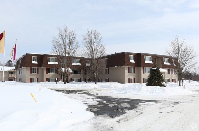
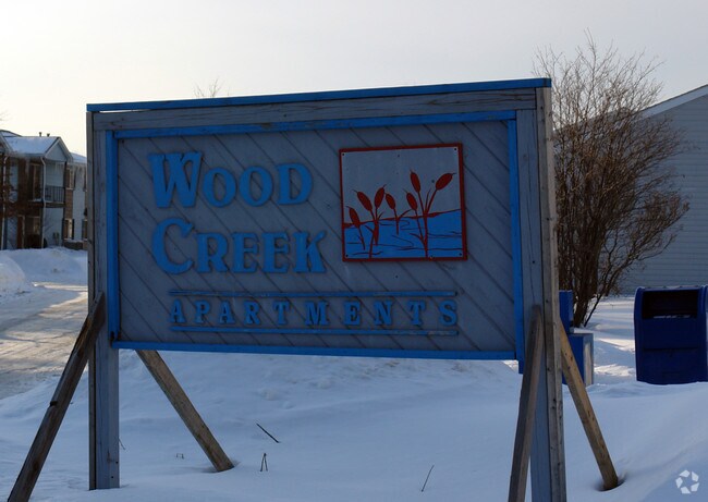
Property Record
Merrick Rd, Rome, NY 13440

NEARBY LISTINGS FOR SALE OR LEASE
-
-
View all Rome listings for sale on LoopNet.com
Property Detail
Merrick Rd
301301 223.007-0001-001
BLDGS&L 14.936A
Apartment
Oneida
X
New York
36065C0552F
1.000
2024
15 AC
2024
Rome
026300
Utica/Rome
12,216 SF
Utica-Rome, NY
DEMOGRAPHICS near Merrick Rd
1 Mile
3 Mile
5 Mile
2024 Total Population
3,520
28,847
36,185
2029 Population
3,482
28,547
35,834
Pop Growth 2024-2029
(1.08%)
(1.04%)
(0.97%)
Average Age
45
41
42
2024 Total Households
1,534
12,653
15,293
HH Growth 2024-2029
(1.04%)
(1.20%)
(1.16%)
Median Household Inc
$66,804
$50,556
$55,673
Avg Household Size
2.20
2.20
2.20
2024 Avg HH Vehicles
2.00
1.00
2.00
Median Home Value
$157,415
$121,977
$137,166
Median Year Built
1956
1954
1955
Nearby Places
Map Layers
Map Styles
 Street
 Aerial
- Restaurants
- Banks
- Shops
- Fitness
- Groceries
PUBLIC TRANSPORTATION
COMMUTER RAIL
Rome (Toronto - New York - VIA Rail)
DRIVE
WALK
Distance
Rome (Toronto - New York - VIA Rail)
8 min
3.6 mi
Rome Amtrak Station (Empire Service - Amtrak, Maple Leaf - Amtrak)
DRIVE
WALK
Distance
Rome Amtrak Station (Empire Service - Amtrak, Maple Leaf - Amtrak)
8 min
3.6 mi
Freight Ports
Albany, NY Port
DRIVE
WALK
Distance
Albany, NY Port
136 min
110.5 mi
Nearby Properties
Address
Land Use
TOTAL SIZE
Lot Size
Zoning
Address
Land Use
TOTAL SIZE
Lot Size
Zoning
234,767 SF
7.70 AC
I
Address
Land Use
TOTAL SIZE
Lot Size
Zoning
70,000 SF
126.93 AC
GB
Address
Land Use
TOTAL SIZE
Lot Size
Zoning
385,216 SF
30.87 AC
GB
Address
Land Use
TOTAL SIZE
Lot Size
Zoning
10.50 AC
NA
Address
Land Use
TOTAL SIZE
Lot Size
Zoning
77,604 SF
4.34 AC
GB
Address
Land Use
TOTAL SIZE
Lot Size
Zoning
60,450 SF
2.95 AC
R-P
Address
Land Use
TOTAL SIZE
Lot Size
Zoning
58,560 SF
2.44 AC
R-P
Address
Land Use
TOTAL SIZE
Lot Size
Zoning
112,259 SF
2.59 AC
C-3
Address
Land Use
TOTAL SIZE
Lot Size
Zoning
10,836 SF
11.24 AC
R-3
Address
Land Use
TOTAL SIZE
Lot Size
Zoning
214,891 SF
22.90 AC
C-2
Address
Land Use
TOTAL SIZE
Lot Size
Zoning
131,001 SF
14.70 AC
R-2
Address
Land Use
TOTAL SIZE
Lot Size
Zoning
173,579 SF
14.46 AC
R-1-8
Address
Land Use
TOTAL SIZE
Lot Size
Zoning
41,262 SF
16.30 AC
R-1-8
Address
Land Use
TOTAL SIZE
Lot Size
Zoning
25,002 SF
6.53 AC
R-3
Address
Land Use
TOTAL SIZE
Lot Size
Zoning
49,643 SF
8 AC
C-1
Address
Land Use
TOTAL SIZE
Lot Size
Zoning
2,630 SF
13.09 AC
R-3
Address
Land Use
TOTAL SIZE
Lot Size
Zoning
3,778 SF
15.52 AC
OS
Address
Land Use
TOTAL SIZE
Lot Size
Zoning
52,721 SF
4.16 AC
GB
Address
Land Use
TOTAL SIZE
Lot Size
Zoning
Address
Land Use
TOTAL SIZE
Lot Size
Zoning
82,918 SF
3.70 AC
W
Address
Land Use
TOTAL SIZE
Lot Size
Zoning
133,723 SF
9.28 AC
C-2
Address
Land Use
TOTAL SIZE
Lot Size
Zoning
70,456 SF
9.74 AC
C-2
Address
Land Use
TOTAL SIZE
Lot Size
Zoning
35,832 SF
0.48 AC
C-3
Address
Land Use
TOTAL SIZE
Lot Size
Zoning
45,984 SF
2.84 AC
GB
Address
Land Use
TOTAL SIZE
Lot Size
Zoning
119,611 SF
35.50 AC
NA
Address
Land Use
TOTAL SIZE
Lot Size
Zoning
287,725 SF
15.43 AC
I-G
Address
Land Use
TOTAL SIZE
Lot Size
Zoning
78,160 SF
15.10 AC
C-1
Address
Land Use
TOTAL SIZE
Lot Size
Zoning
56,220 SF
1.67 AC
GB
Address
Land Use
TOTAL SIZE
Lot Size
Zoning
63,788 SF
6.65 AC
GB
Address
Land Use
TOTAL SIZE
Lot Size
Zoning
37.90 AC
The World's #1 Commercial Real Estate Marketplace
Connect with us
© 2025 CoStar Group
The information above has been obtained from sources believed reliable. While we do not doubt its accuracy we have not verified it and make no guarantee, warranty or representation about it. It is your responsibility to independently confirm its accuracy and completeness. Any projections, opinions, assumptions, or estimates used are for example only and do not represent the current or future performance of the property. The value of this transaction to you depends on tax and other factors which should be evaluated by your tax, financial, and legal advisors. You and your advisors should conduct a careful, independent investigation of the property to determine to your satisfaction the suitability of the property for your needs.