Property Record
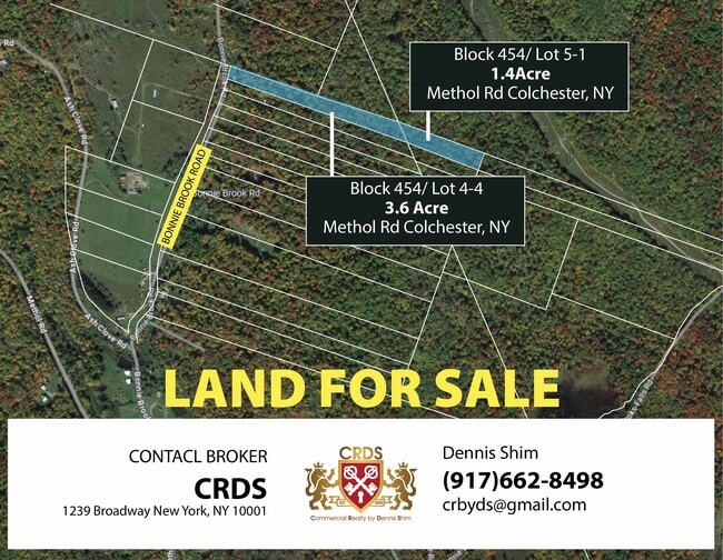
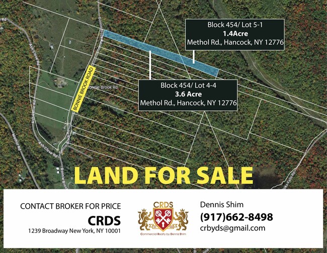
Methol Rd, , NY
Save to a Folder
{{folder.Name}}
{{folder.ListingIds.length}} Properties
{{folder.ListingIds.length}} Property
Create a New Folder
This Property Is For Sale
Property Detail
Methol Rd
Other Market Areas
HARDENBURGH P L-19
122400-454-000-0005-001-000
DELAWARE
Agriculturalland
New York
B and X Area of moderate flood hazard, usually the area between the limits of the 100-year and 500-year floods.
1.000
2025
1.40 AC
2025
Hudson Valley Area
9713001174
NEARBY LISTINGS FOR SALE OR LEASE
-
-
View all listings for sale on LoopNet.com
DEMOGRAPHICS near Methol Rd
1 mile
3 mile
5 mile
2025 Total Population
59
783
1,863
2030 Population
62
834
1,947
Pop Growth 2025-2030
+ 5.08%
+ 6.51%
+ 4.51%
Average Age
49
50
48
2025 Total Households
27
363
851
HH Growth 2025-2030
+ 7.41%
+ 6.89%
+ 5.05%
Median Household Inc
$87,500
$76,087
$68,124
Avg Household Size
2.00
2.10
2.10
2025 Avg HH Vehicles
2.00
2.00
2.00
Median Home Value
$189,999
$295,832
$245,698
Median Year Built
1977
1981
1979
Nearby Places
Map Layers
Map Styles
 Street
 Aerial
Layers
 Traffic
 Biking
Places
Listings with unknown addresses are not visible on the map
- Restaurants
- Banks
- Shops
- Fitness
- Groceries
Nearby Properties
Address
Land Use
TOTAL SIZE
Lot Size
Zoning
Address
Land Use
TOTAL SIZE
Lot Size
Zoning
1,600 SF
94.50 AC
RR
Address
Land Use
TOTAL SIZE
Lot Size
Zoning
6,153 SF
1.24 AC
LC 2
Address
Land Use
TOTAL SIZE
Lot Size
Zoning
304.48 AC
RC
Address
Land Use
TOTAL SIZE
Lot Size
Zoning
800 SF
0.59 AC
LC 2
Address
Land Use
TOTAL SIZE
Lot Size
Zoning
215.65 AC
MC1
Address
Land Use
TOTAL SIZE
Lot Size
Zoning
176.60 AC
RC
Address
Land Use
TOTAL SIZE
Lot Size
Zoning
800 SF
105 AC
RR
Address
Land Use
TOTAL SIZE
Lot Size
Zoning
87.60 AC
RR
Address
Land Use
TOTAL SIZE
Lot Size
Zoning
80.60 AC
RR
Address
Land Use
TOTAL SIZE
Lot Size
Zoning
181.54 AC
N
Address
Land Use
TOTAL SIZE
Lot Size
Zoning
111 AC
MC1
Address
Land Use
TOTAL SIZE
Lot Size
Zoning
67.50 AC
RR
Address
Land Use
TOTAL SIZE
Lot Size
Zoning
755 AC
N
Address
Land Use
TOTAL SIZE
Lot Size
Zoning
1.35 AC
RR
Address
Land Use
TOTAL SIZE
Lot Size
Zoning
89.29 AC
RC
Address
Land Use
TOTAL SIZE
Lot Size
Zoning
114 AC
RR
Address
Land Use
TOTAL SIZE
Lot Size
Zoning
115 AC
RR
Address
Land Use
TOTAL SIZE
Lot Size
Zoning
56.45 AC
MC1
Address
Land Use
TOTAL SIZE
Lot Size
Zoning
8.35 AC
RR
Address
Land Use
TOTAL SIZE
Lot Size
Zoning
58.98 AC
RR
Address
Land Use
TOTAL SIZE
Lot Size
Zoning
80 AC
RR
Address
Land Use
TOTAL SIZE
Lot Size
Zoning
34.86 AC
MC1
Address
Land Use
TOTAL SIZE
Lot Size
Zoning
1 AC
RR
Address
Land Use
TOTAL SIZE
Lot Size
Zoning
0.50 AC
Address
Land Use
TOTAL SIZE
Lot Size
Zoning
0.48 AC
RR
Address
Land Use
TOTAL SIZE
Lot Size
Zoning
2,156 SF
5.80 AC
N
Address
Land Use
TOTAL SIZE
Lot Size
Zoning
4.61 AC
N
Address
Land Use
TOTAL SIZE
Lot Size
Zoning
0.11 AC
RR
Address
Land Use
TOTAL SIZE
Lot Size
Zoning
400 SF
45.86 AC
RC
Address
Land Use
TOTAL SIZE
Lot Size
Zoning
0.28 AC
RR
The World's #1 Commercial Real Estate Marketplace
Connect with us
© 2026 CoStar Group
The information above has been obtained from sources believed reliable. While we do not doubt its accuracy we have not verified it and make no guarantee, warranty or representation about it. It is your responsibility to independently confirm its accuracy and completeness. Any projections, opinions, assumptions, or estimates used are for example only and do not represent the current or future performance of the property. The value of this transaction to you depends on tax and other factors which should be evaluated by your tax, financial, and legal advisors. You and your advisors should conduct a careful, independent investigation of the property to determine to your satisfaction the suitability of the property for your needs.