Property Record
Mexico Rd, St Peters, MO 63376


Save to a Folder
{{folder.Name}}
{{folder.ListingIds.length}} Properties
{{folder.ListingIds.length}} Property
Create a New Folder
Property Detail
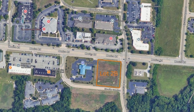
Mexico Rd
St. Louis, MO-IL
ST PETERS CENTRE SOUTH RESUB LOT 2 LOT 2B
2-0146-A849-00-002B.0000000
ST. CHARLES
Vacantlandnec
Missouri
B and X Area of moderate flood hazard, usually the area between the limits of the 100-year and 500-year floods.
2b
2024
1.47 AC
2025
St Charles County
311311
St. Louis
NEARBY LISTINGS FOR SALE OR LEASE
DEMOGRAPHICS near Mexico Rd
1 mile
3 mile
5 mile
2025 Total Population
7,821
68,264
169,054
2030 Population
8,041
70,246
174,188
Pop Growth 2025-2030
+ 2.81%
+ 2.90%
+ 3.04%
Average Age
44
43
42
2025 Total Households
3,163
28,040
68,094
HH Growth 2025-2030
+ 3.32%
+ 3.16%
+ 3.21%
Median Household Inc
$87,652
$86,378
$89,421
Avg Household Size
2.30
2.40
2.40
2025 Avg HH Vehicles
2.00
2.00
2.00
Median Home Value
$274,784
$274,844
$287,892
Median Year Built
1993
1984
1985
Nearby Places
Map Layers
Map Styles
 Street
 Aerial
Layers
 Traffic
 Biking
Places
Listings with unknown addresses are not visible on the map
- Restaurants
- Banks
- Shops
- Fitness
- Groceries
PUBLIC TRANSPORTATION
AIRPORT
St Louis Lambert International
Drive
Walk
Distance
St Louis Lambert International
23 min
15.6 mi
Freight Ports
Port Milwaukee
Drive
Walk
Distance
Port Milwaukee
442 min
388.7 mi
SALE & LEASE HISTORY
LISTING DATE
SALE/LEASE

Sep 24, 2016
For Sale
Nearby Properties
Address
Land Use
TOTAL SIZE
Lot Size
Zoning
Address
Land Use
TOTAL SIZE
Lot Size
Zoning
855,000 SF
39.97 AC
Address
Land Use
TOTAL SIZE
Lot Size
Zoning
500,420 SF
99.80 AC
Address
Land Use
TOTAL SIZE
Lot Size
Zoning
719,340 SF
48.06 AC
Address
Land Use
TOTAL SIZE
Lot Size
Zoning
810,640 SF
48.73 AC
Address
Land Use
TOTAL SIZE
Lot Size
Zoning
375,200 SF
24.65 AC
Address
Land Use
TOTAL SIZE
Lot Size
Zoning
423,000 SF
18.07 AC
Address
Land Use
TOTAL SIZE
Lot Size
Zoning
136,142 SF
31.16 AC
Address
Land Use
TOTAL SIZE
Lot Size
Zoning
253,800 SF
17.09 AC
Address
Land Use
TOTAL SIZE
Lot Size
Zoning
279,526 SF
7.73 AC
Address
Land Use
TOTAL SIZE
Lot Size
Zoning
490,200 SF
36.53 AC
Address
Land Use
TOTAL SIZE
Lot Size
Zoning
433,744 SF
19.38 AC
Address
Land Use
TOTAL SIZE
Lot Size
Zoning
182,783 SF
19.83 AC
Address
Land Use
TOTAL SIZE
Lot Size
Zoning
449,111 SF
16.30 AC
AE2
Address
Land Use
TOTAL SIZE
Lot Size
Zoning
197,290 SF
29.28 AC
Address
Land Use
TOTAL SIZE
Lot Size
Zoning
87,027 SF
16.04 AC
AC4
Address
Land Use
TOTAL SIZE
Lot Size
Zoning
337,411 SF
7.97 AC
Address
Land Use
TOTAL SIZE
Lot Size
Zoning
56,430 SF
14.72 AC
AE8
Address
Land Use
TOTAL SIZE
Lot Size
Zoning
246,351 SF
9.69 AC
Address
Land Use
TOTAL SIZE
Lot Size
Zoning
55.46 AC
AF0
Address
Land Use
TOTAL SIZE
Lot Size
Zoning
220,089 SF
25.47 AC
AA7
Address
Land Use
TOTAL SIZE
Lot Size
Zoning
199,216 SF
10.26 AC
Address
Land Use
TOTAL SIZE
Lot Size
Zoning
63.61 AC
AC9
Address
Land Use
TOTAL SIZE
Lot Size
Zoning
46,980 SF
4.15 AC
AF0
Address
Land Use
TOTAL SIZE
Lot Size
Zoning
23,262 SF
7.05 AC
Address
Land Use
TOTAL SIZE
Lot Size
Zoning
41,256 SF
4.98 AC
Address
Land Use
TOTAL SIZE
Lot Size
Zoning
366,600 SF
12.88 AC
Address
Land Use
TOTAL SIZE
Lot Size
Zoning
299,880 SF
23.23 AC
Address
Land Use
TOTAL SIZE
Lot Size
Zoning
160,312 SF
6.82 AC
Address
Land Use
TOTAL SIZE
Lot Size
Zoning
203,833 SF
13.92 AC
AE8
Address
Land Use
TOTAL SIZE
Lot Size
Zoning
50,984 SF
9.53 AC
The World's #1 Commercial Real Estate Marketplace
Connect with us
© 2026 CoStar Group
The information above has been obtained from sources believed reliable. While we do not doubt its accuracy we have not verified it and make no guarantee, warranty or representation about it. It is your responsibility to independently confirm its accuracy and completeness. Any projections, opinions, assumptions, or estimates used are for example only and do not represent the current or future performance of the property. The value of this transaction to you depends on tax and other factors which should be evaluated by your tax, financial, and legal advisors. You and your advisors should conduct a careful, independent investigation of the property to determine to your satisfaction the suitability of the property for your needs.