Property Record
Middletown Eaton Rd, Middletown, OH 45042
Save to a Folder
{{folder.Name}}
{{folder.ListingIds.length}} Properties
{{folder.ListingIds.length}} Property
Create a New Folder
This Property Is For Sale
Property Detail
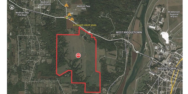
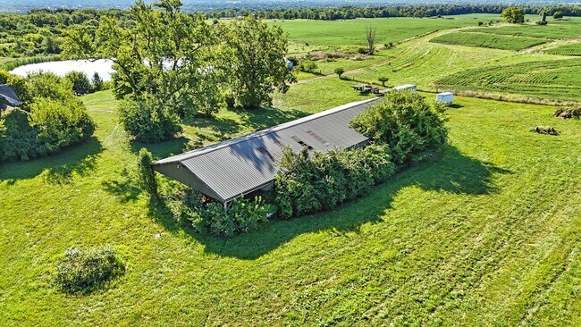
Middletown Eaton Rd
Cincinnati, OH-KY-IN
8 ENT BURNSIDE SUB
E2220-100-000-002
BUTLER
Agriculturalland
Ohio
B and X Area of moderate flood hazard, usually the area between the limits of the 100-year and 500-year floods.
2-13
2025
0.68 AC
2025
Butler County
012200
Cincinnati/Dayton
NEARBY LISTINGS FOR SALE OR LEASE
DEMOGRAPHICS near Middletown Eaton Rd
1 mile
3 mile
5 mile
2025 Total Population
973
27,407
72,707
2030 Population
990
28,317
74,986
Pop Growth 2025-2030
+ 1.75%
+ 3.32%
+ 3.13%
Average Age
42
38
39
2025 Total Households
362
10,568
28,534
HH Growth 2025-2030
+ 1.93%
+ 3.41%
+ 3.20%
Median Household Inc
$87,837
$51,077
$60,996
Avg Household Size
2.60
2.50
2.50
2025 Avg HH Vehicles
2.00
2.00
2.00
Median Home Value
$324,666
$181,521
$193,091
Median Year Built
1965
1956
1964
Nearby Places
Map Layers
Map Styles
 Street
 Aerial
Layers
 Traffic
 Biking
Places
Listings with unknown addresses are not visible on the map
- Restaurants
- Banks
- Shops
- Fitness
- Groceries
PUBLIC TRANSPORTATION
AIRPORT
James M Cox Dayton International
Drive
Walk
Distance
James M Cox Dayton International
56 min
38.8 mi
Freight Ports
Port of Toledo
Drive
Walk
Distance
Port of Toledo
213 min
179.0 mi
Nearby Properties
Address
Land Use
TOTAL SIZE
Lot Size
Zoning
Address
Land Use
TOTAL SIZE
Lot Size
Zoning
7.19 AC
Address
Land Use
TOTAL SIZE
Lot Size
Zoning
27.87 AC
Address
Land Use
TOTAL SIZE
Lot Size
Zoning
84,352 SF
0.30 AC
Address
Land Use
TOTAL SIZE
Lot Size
Zoning
54,005 SF
0.33 AC
Address
Land Use
TOTAL SIZE
Lot Size
Zoning
Address
Land Use
TOTAL SIZE
Lot Size
Zoning
33,362 SF
0.73 AC
Address
Land Use
TOTAL SIZE
Lot Size
Zoning
9,069 SF
115.70 AC
Address
Land Use
TOTAL SIZE
Lot Size
Zoning
166 AC
ADV
Address
Land Use
TOTAL SIZE
Lot Size
Zoning
16,779 SF
2.19 AC
Address
Land Use
TOTAL SIZE
Lot Size
Zoning
499,497 SF
20.30 AC
ADV
Address
Land Use
TOTAL SIZE
Lot Size
Zoning
236,670 SF
17.78 AC
Address
Land Use
TOTAL SIZE
Lot Size
Zoning
20,160 SF
0.10 AC
Address
Land Use
TOTAL SIZE
Lot Size
Zoning
522,237 SF
11.14 AC
ADV
Address
Land Use
TOTAL SIZE
Lot Size
Zoning
0.09 AC
Address
Land Use
TOTAL SIZE
Lot Size
Zoning
40,076 SF
5.91 AC
Address
Land Use
TOTAL SIZE
Lot Size
Zoning
140,045 SF
3.82 AC
Address
Land Use
TOTAL SIZE
Lot Size
Zoning
59,280 SF
3.12 AC
Address
Land Use
TOTAL SIZE
Lot Size
Zoning
20,939 SF
5.33 AC
Address
Land Use
TOTAL SIZE
Lot Size
Zoning
12,268 SF
0.11 AC
Address
Land Use
TOTAL SIZE
Lot Size
Zoning
15.51 AC
ADV
Address
Land Use
TOTAL SIZE
Lot Size
Zoning
8,000 SF
0.02 AC
Address
Land Use
TOTAL SIZE
Lot Size
Zoning
26,076 SF
160.34 AC
Address
Land Use
TOTAL SIZE
Lot Size
Zoning
20,592 SF
3.79 AC
Address
Land Use
TOTAL SIZE
Lot Size
Zoning
275,521 SF
30.35 AC
ADV
Address
Land Use
TOTAL SIZE
Lot Size
Zoning
20,040 SF
1.21 AC
Address
Land Use
TOTAL SIZE
Lot Size
Zoning
3,280 SF
128.27 AC
ADV
Address
Land Use
TOTAL SIZE
Lot Size
Zoning
156,276 SF
7.67 AC
Address
Land Use
TOTAL SIZE
Lot Size
Zoning
Address
Land Use
TOTAL SIZE
Lot Size
Zoning
26,540 SF
0.32 AC
Address
Land Use
TOTAL SIZE
Lot Size
Zoning
42,000 SF
13.64 AC
The World's #1 Commercial Real Estate Marketplace
Connect with us
© 2026 CoStar Group
The information above has been obtained from sources believed reliable. While we do not doubt its accuracy we have not verified it and make no guarantee, warranty or representation about it. It is your responsibility to independently confirm its accuracy and completeness. Any projections, opinions, assumptions, or estimates used are for example only and do not represent the current or future performance of the property. The value of this transaction to you depends on tax and other factors which should be evaluated by your tax, financial, and legal advisors. You and your advisors should conduct a careful, independent investigation of the property to determine to your satisfaction the suitability of the property for your needs.