Property Record
Mieras Rd Beaudry, Yakima, WA 98901


NEARBY LISTINGS FOR SALE OR LEASE
-
-
View all Yakima listings for sale on LoopNet.com
Property Detail
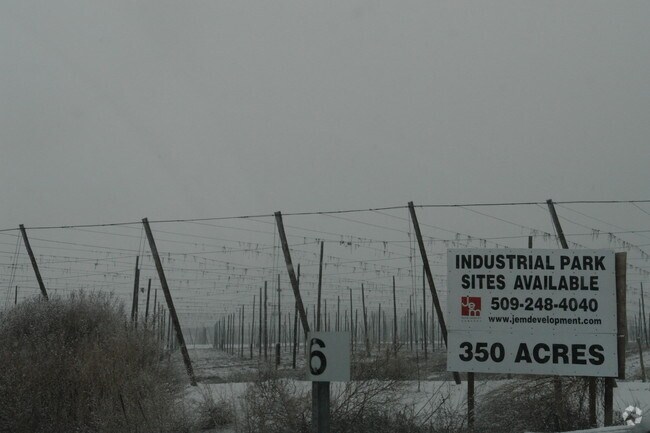
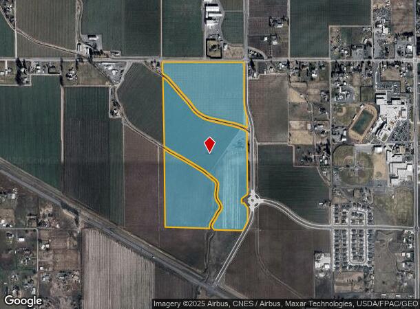
Mieras Rd Beaudry
Yakima, WA
Union Gap Canal
191335-21002
SECTION 35 TOWNSHIP 13 RANGE 19 QUARTER NW: THE EAST HALF OF THE NW1/4 OF SECTION 35, EXCEPT RIGHT OF WAY FOR HUBBARD DITCH, AND EXCEPT RIGHT OF WAY FOR UNION GAP IRRIGATION DISTRICT CANAL, AND EXCEPT RIGHT OF WAY FOR COUNTY ROAD ALONG THE NORTH LINE
Agriculturalland
Yakima
X
Washington
53077C1058D
74.33 AC
2025
Outlying Yakima County
2025
Yakima
001602
DEMOGRAPHICS near Mieras Rd Beaudry
1 Mile
3 Mile
5 Mile
2024 Total Population
706
16,213
50,948
2029 Population
717
16,249
51,044
Pop Growth 2024-2029
+ 1.56%
+ 0.22%
+ 0.19%
Average Age
39
38
35
2024 Total Households
236
5,847
17,203
HH Growth 2024-2029
+ 1.27%
+ 0.27%
+ 0.17%
Median Household Inc
$99,038
$73,429
$53,566
Avg Household Size
3.00
2.70
2.90
2024 Avg HH Vehicles
3.00
2.00
2.00
Median Home Value
$291,463
$313,948
$220,180
Median Year Built
1993
1991
1974
Nearby Places
Map Layers
Map Styles
 Street
 Aerial
- Restaurants
- Banks
- Shops
- Fitness
- Groceries
PUBLIC TRANSPORTATION
AIRPORT
Yakima Air Trml/McAllister Field
DRIVE
WALK
Distance
Yakima Air Trml/McAllister Field
19 min
7.7 mi
Freight Ports
Port of Tacoma
DRIVE
WALK
Distance
Port of Tacoma
192 min
159.7 mi
Nearby Properties
Address
Land Use
TOTAL SIZE
Lot Size
Zoning
Address
Land Use
TOTAL SIZE
Lot Size
Zoning
295,494 SF
32.20 AC
R1
Address
Land Use
TOTAL SIZE
Lot Size
Zoning
197,341 SF
36.70 AC
GC
Address
Land Use
TOTAL SIZE
Lot Size
Zoning
807,762 SF
18.86 AC
M1
Address
Land Use
TOTAL SIZE
Lot Size
Zoning
129,042 SF
6.53 AC
R3
Address
Land Use
TOTAL SIZE
Lot Size
Zoning
121,488 SF
5.97 AC
R3
Address
Land Use
TOTAL SIZE
Lot Size
Zoning
184,623 SF
9.61 AC
M1
Address
Land Use
TOTAL SIZE
Lot Size
Zoning
97,056 SF
5.80 AC
R3
Address
Land Use
TOTAL SIZE
Lot Size
Zoning
102,104 SF
12.58 AC
PUB
Address
Land Use
TOTAL SIZE
Lot Size
Zoning
135,634 SF
9.84 AC
C1
Address
Land Use
TOTAL SIZE
Lot Size
Zoning
84,714 SF
4.40 AC
R3
Address
Land Use
TOTAL SIZE
Lot Size
Zoning
77,472 SF
33.76 AC
R1
Address
Land Use
TOTAL SIZE
Lot Size
Zoning
83,856 SF
4.23 AC
R3
Address
Land Use
TOTAL SIZE
Lot Size
Zoning
114,406 SF
15.50 AC
PUB
Address
Land Use
TOTAL SIZE
Lot Size
Zoning
64,593 SF
10.02 AC
R1
Address
Land Use
TOTAL SIZE
Lot Size
Zoning
128,170 SF
9.68 AC
M1
Address
Land Use
TOTAL SIZE
Lot Size
Zoning
76,160 SF
39.51 AC
M1
Address
Land Use
TOTAL SIZE
Lot Size
Zoning
69.87 AC
SR
Address
Land Use
TOTAL SIZE
Lot Size
Zoning
204,600 SF
12.54 AC
B2
Address
Land Use
TOTAL SIZE
Lot Size
Zoning
9,121 SF
0.22 AC
C1
Address
Land Use
TOTAL SIZE
Lot Size
Zoning
159,116 SF
12.77 AC
M1
Address
Land Use
TOTAL SIZE
Lot Size
Zoning
125,789 SF
7.15 AC
C1
Address
Land Use
TOTAL SIZE
Lot Size
Zoning
141,696 SF
6.42 AC
M1
Address
Land Use
TOTAL SIZE
Lot Size
Zoning
150,000 SF
16.97 AC
M1
Address
Land Use
TOTAL SIZE
Lot Size
Zoning
56,973 SF
6.06 AC
R3
Address
Land Use
TOTAL SIZE
Lot Size
Zoning
50,384 SF
8.56 AC
PUB
Address
Land Use
TOTAL SIZE
Lot Size
Zoning
30,327 SF
3.52 AC
GC
Address
Land Use
TOTAL SIZE
Lot Size
Zoning
112,766 SF
10.57 AC
C1
Address
Land Use
TOTAL SIZE
Lot Size
Zoning
93,456 SF
7.09 AC
C1
Address
Land Use
TOTAL SIZE
Lot Size
Zoning
165,000 SF
19.05 AC
M1
The World's #1 Commercial Real Estate Marketplace
Connect with us
© 2025 CoStar Group
The information above has been obtained from sources believed reliable. While we do not doubt its accuracy we have not verified it and make no guarantee, warranty or representation about it. It is your responsibility to independently confirm its accuracy and completeness. Any projections, opinions, assumptions, or estimates used are for example only and do not represent the current or future performance of the property. The value of this transaction to you depends on tax and other factors which should be evaluated by your tax, financial, and legal advisors. You and your advisors should conduct a careful, independent investigation of the property to determine to your satisfaction the suitability of the property for your needs.